Northeast: Here’s When Winter Storm Is Arriving
The historic, widespread, long-lasting winter storm has already blanketed parts of the South and Plains with ice and snow, and will target millions more in the Midwest and Northeast through Monday.
Widespread dangerous travel will linger for days and “catastrophic” ice accumulations in the South could lead to widespread power outages and tree damage, according to NOAA’s Weather Prediction Center.
The storm has been named Winter Storm Fern by The Weather Channel. According to The Weather Company forecasters, Fern could affect over 230 million in the U.S. with significant snow and/or ice, two-thirds of the nation’s estimated population. Either heavy snow or ice is forecast for 34 states from the storm, from Arizona to the Midwest, South and New England. Its impacts will linger for some time after the storm ends.
![]()
Weather in your inbox
By signing up you agree to the Terms & Privacy Policy. Unsubscribe at any time.
(MORE: America Prepares For Winter Storm | Winter Storm Tracker)
Happening Now
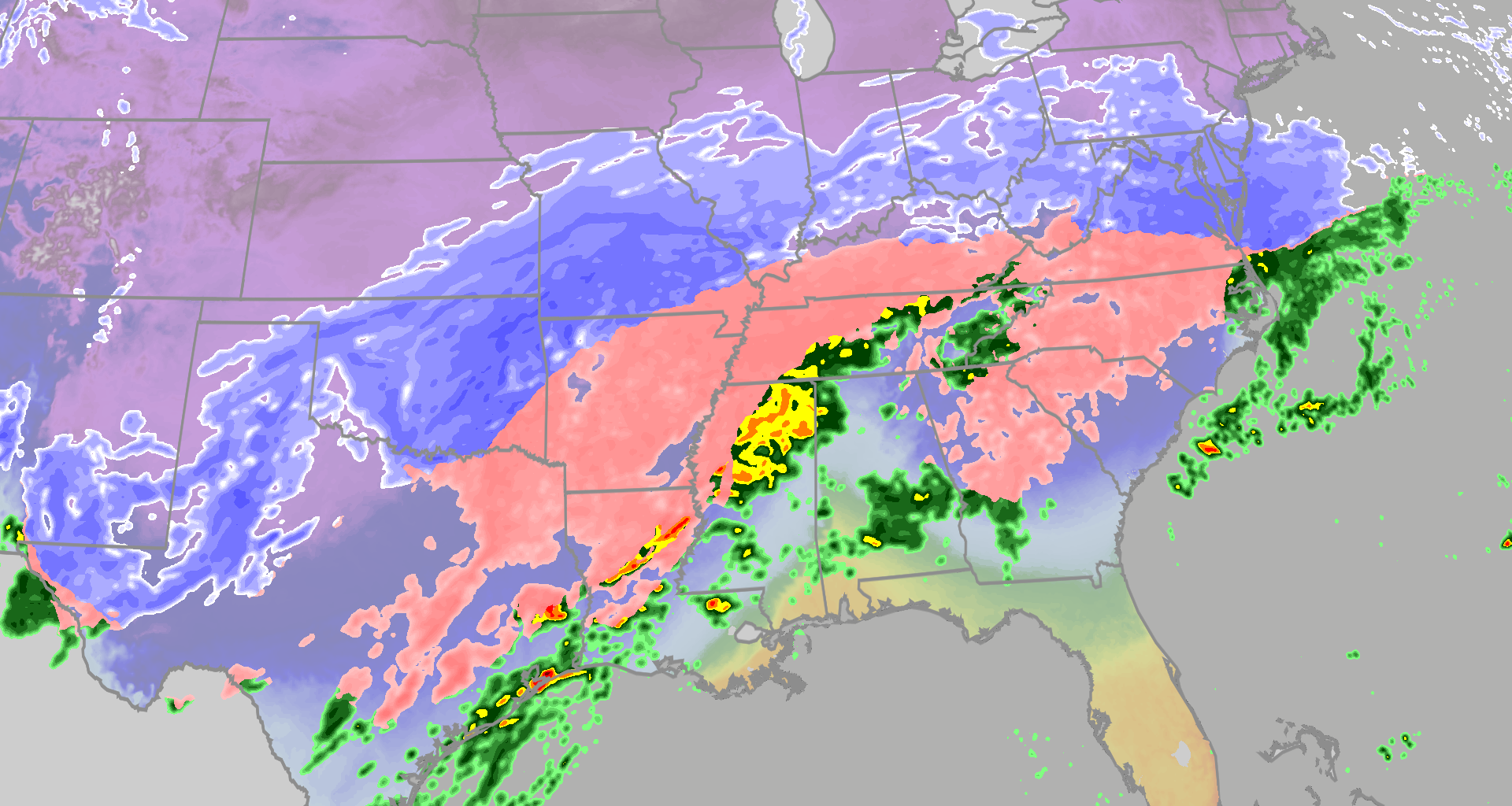
A large area of snow, sleet and freezing rain has spread across the Plains and South, and it will continue to intensify in the Tennessee and Ohio Valleys through the day.
Some reports of light snow are coming in as far east as the Appalachians of southern West Virginia and western Virginia, and some freezing rain and sleet has been reported as far east as northern Alabama, far northern Georgia and eastern Tennessee.
So far, up to 6 inches of snow has been reported in the Little Rock, Arkansas, metro area, as well as near Hays, Kansas. Four inches of snow was reported near Abilene, Texas. Some sleet, freezing rain and snow has also moved into the Dallas-Ft. Worth metro this morning.
 How Much Ice?
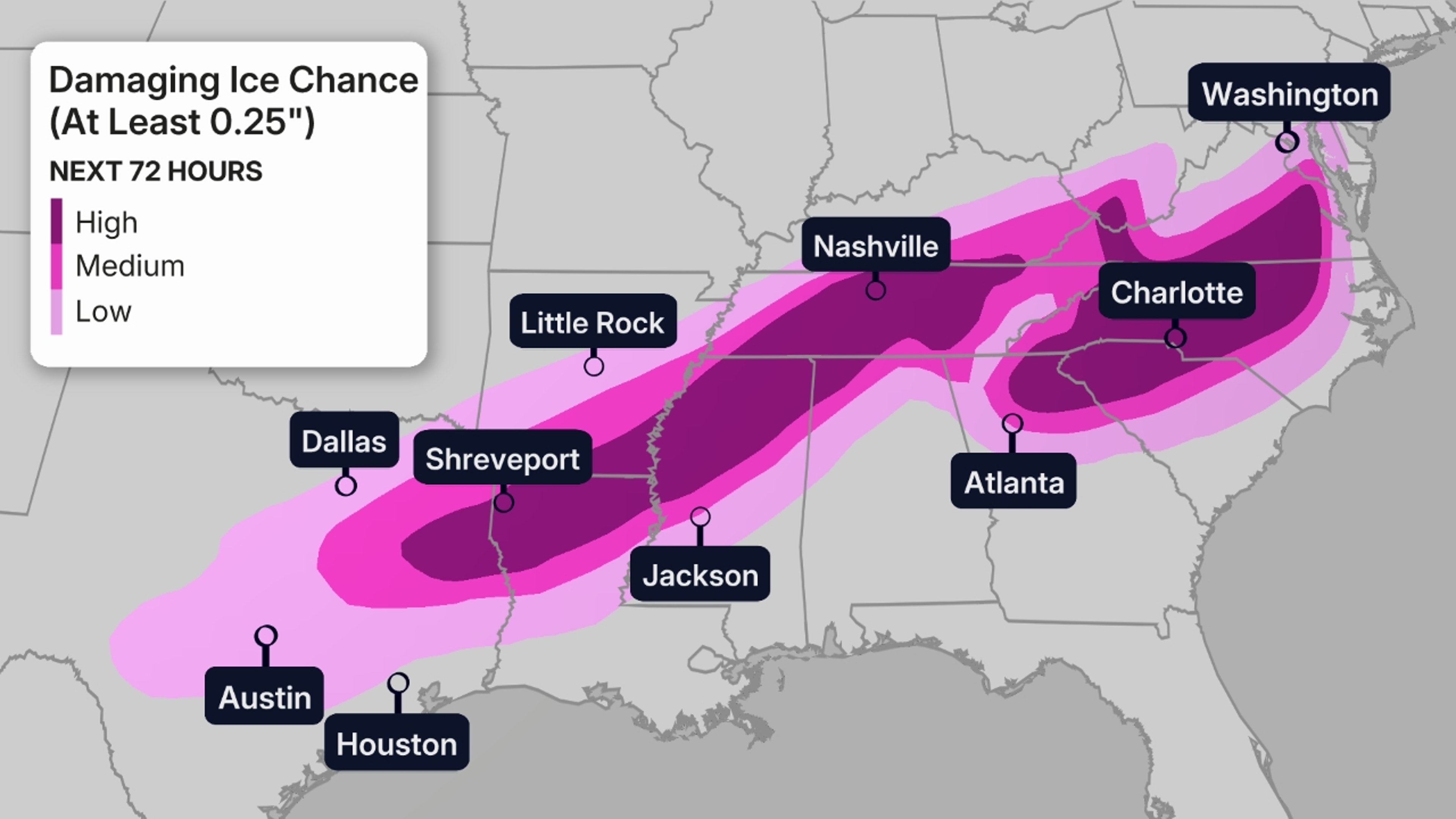
The map below shows the chance of at least one-quarter inch of ice accumulation during the storm, a threshold where tree damage and power outages ramp up quickly, in addition to making roads ice-covered and hazardous.
Areas in the darker purple contours may see even higher accumulations that could lead to extensive tree damage and numerous, widespread power outages. The highest threat of destructive ice covers parts of 12 states, from Texas to Virginia, including cities such as Shreveport, Nashville, parts of the Atlanta metro area, Greenville-Spartanburg, Charlotte, Raleigh-Durham and Richmond.
Winds during the storm could add even more stress to trees and power lines weighed down by ice, increasing the damaging potential of this ice storm.
If you’re in the areas contoured in the map below, you need to prepare for the potential of a power outage that could last as long as a few days, especially considering cold air will plunge into the region during and after the storm.
(MORE: Things To Know About Ice Storms | What Ice Accumulations Mean For Impacts)
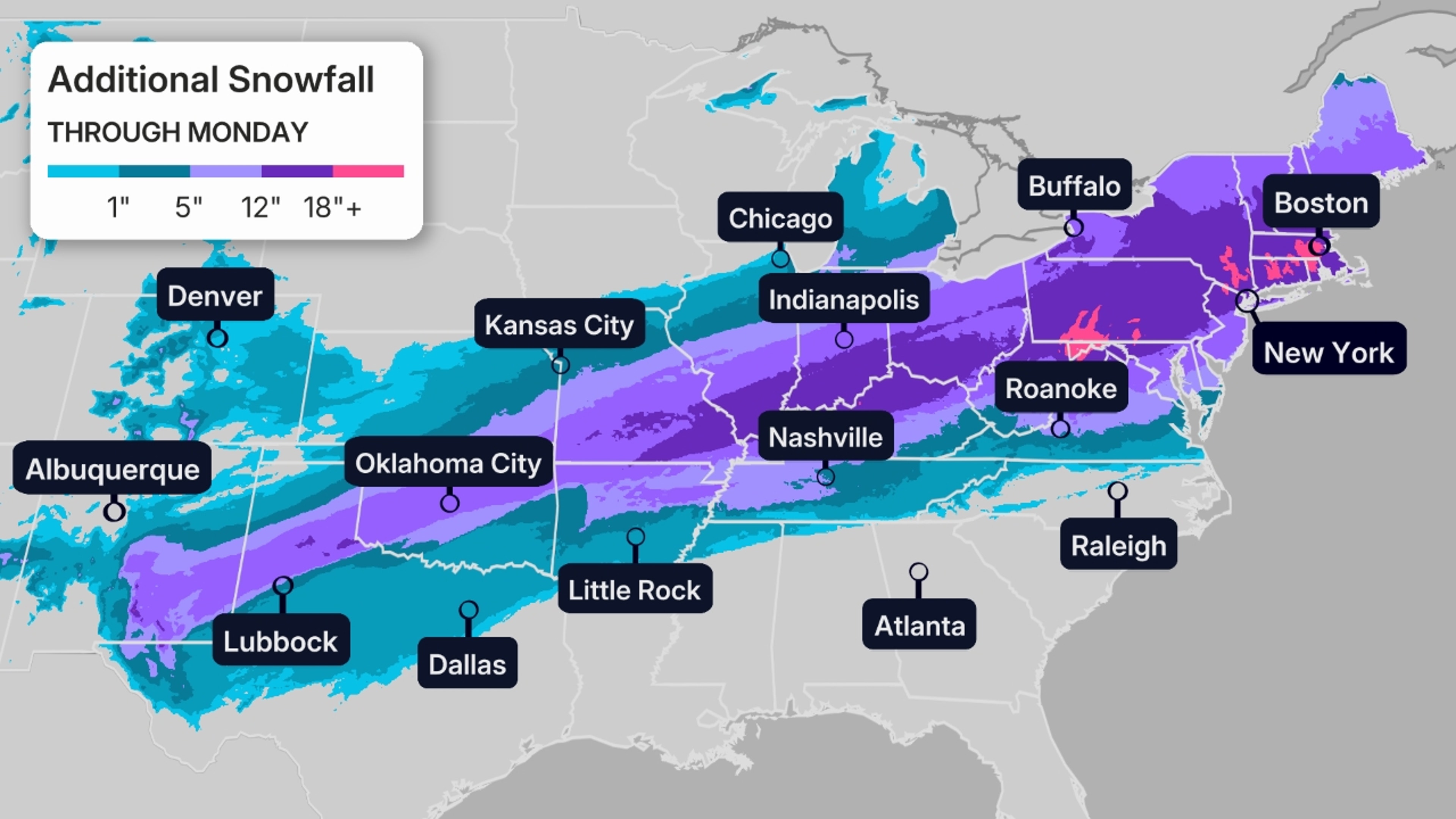
 How Much Snow?
A broad swath from the Texas Panhandle and Oklahoma to the Ohio Valley and Northeast will likely pick up at least 6 inches of snow through Monday. Many of these areas have a good chance of measuring a foot or more of snow, as shown by the darkest purple and pink contours in the map below.
This could lead to dangerous travel conditions in these areas, with some roads possibly becoming impassable by this weekend, especially in the southern portion of heaviest snow swath.
This is also likely to trigger significant flight delays and cancellations, especially Sunday into Monday at the major East Coast hubs.
If you have travel plans in these areas, we strongly urge you to either postpone or cancel them.
(MORE: Where Fern Could Be Historic)
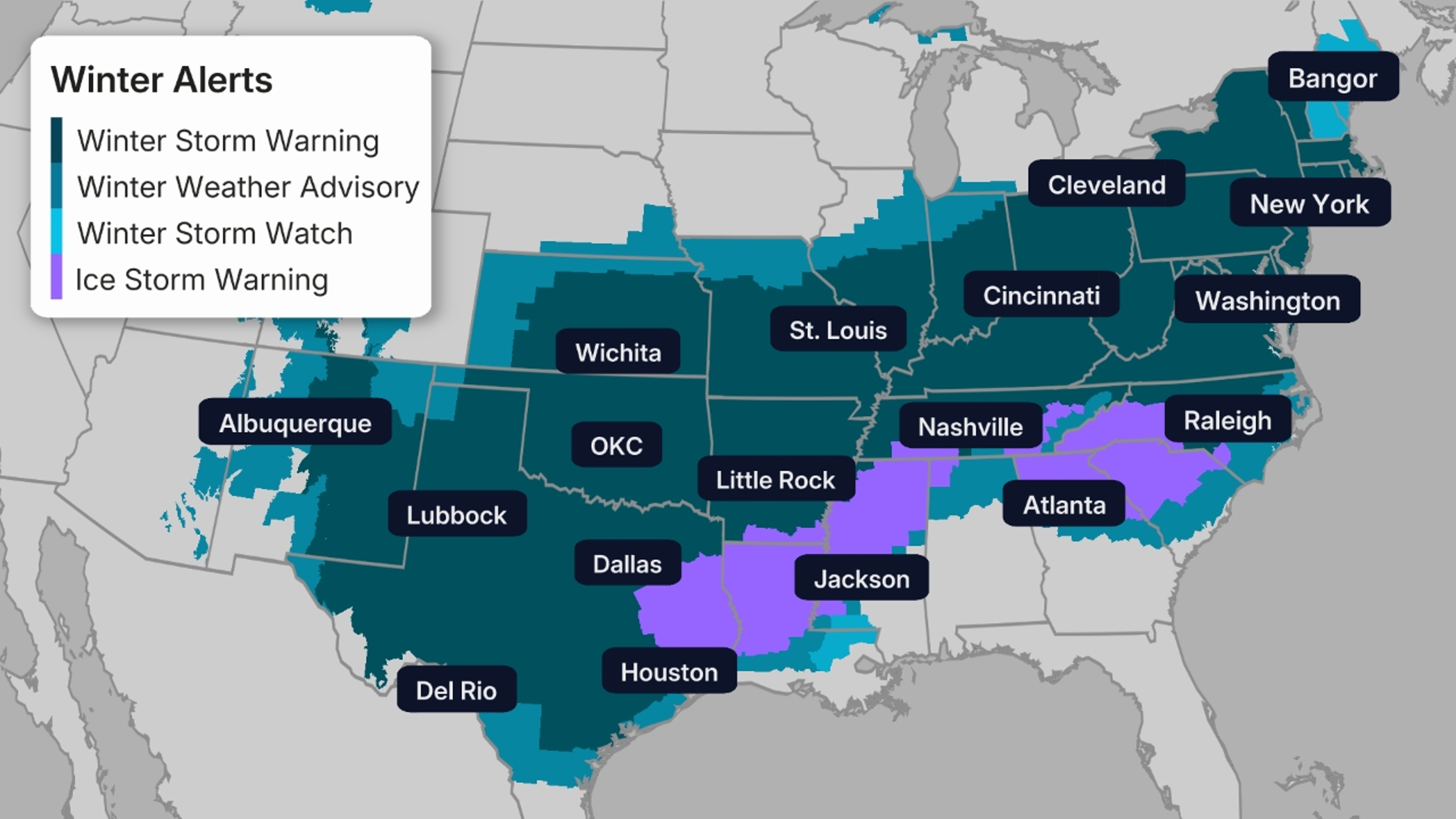
 Winter Storm Alerts
Winter storm alerts have been issued by the National Weather Service from the southern Rockies to the East Coast, covering dozens of major cities including Dallas, Houston, San Antonio, Nashville, Atlanta, Charlotte, Cincinnati, Pittsburgh, Washington, D.C., Philadelphia, New York City and Boston.
Impacts are expected to be most severe in areas where winter storm warnings and ice storm warnings will eventually be issued. Here’s what these warnings mean:
Winter storm warning: A high expectation of disruptive, significant snow, ice and/or sleet. Mixed precipitation is likely in a lot of places. Power outages are expected and travel could be impossible.
Ice storm warning: A high expectation that ice/freezing rain will be the main precipitation type and that it will be disruptive and damaging. Power outages are expected and travel will be impossible. Some of the most significant damage this weekend will come from these zones.
Pay attention to the timing of these alerts in The Weather Channel app.
(MORE: Winter Storm Fern Maps Tracker)
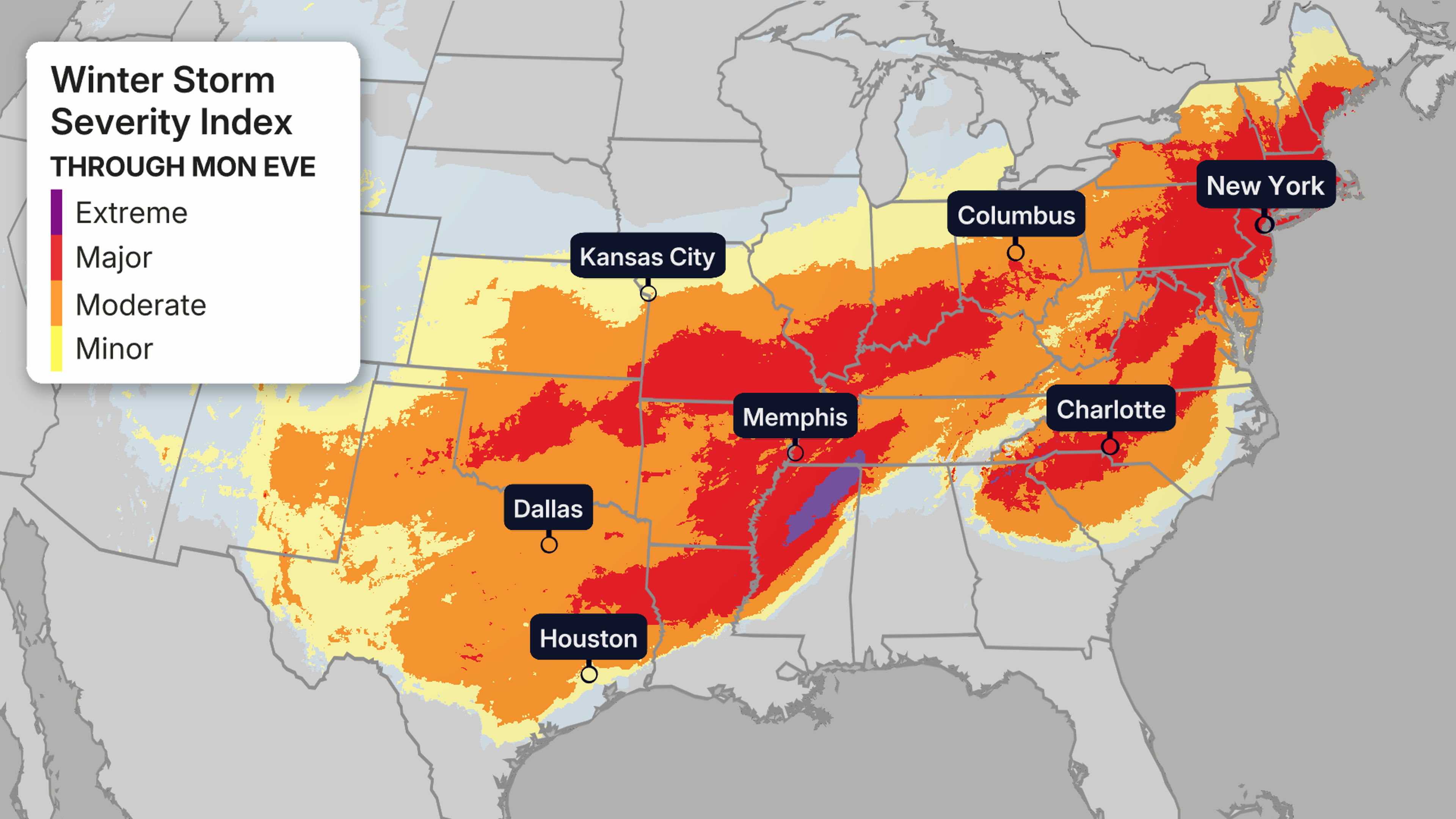
 How Bad Could It Get?
This index from the National Weather Service attempts to quantify the impacts from winter weather, taking into account factors such as snowfall, accumulated snow on rooftops, ice accumulation, the potential for a flash freeze, and blowing snow. Not all factors are in play in a given winter storm.
Descriptions of each level of severity can be found here.
 Timing And Cities Impacted
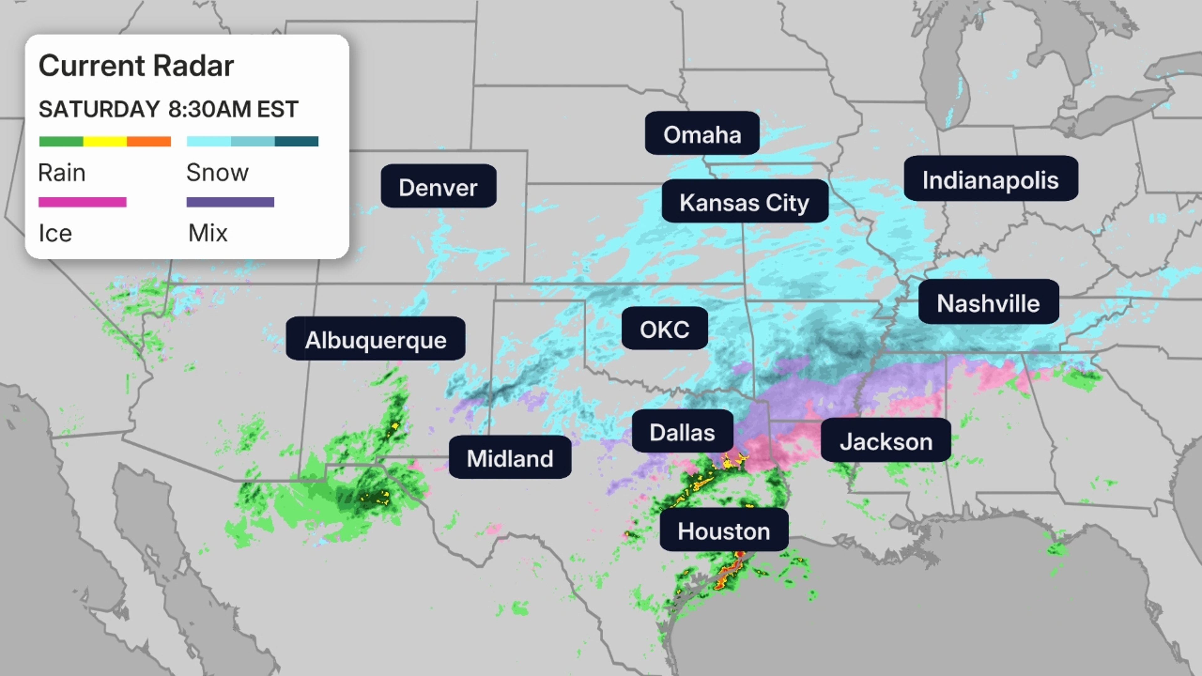
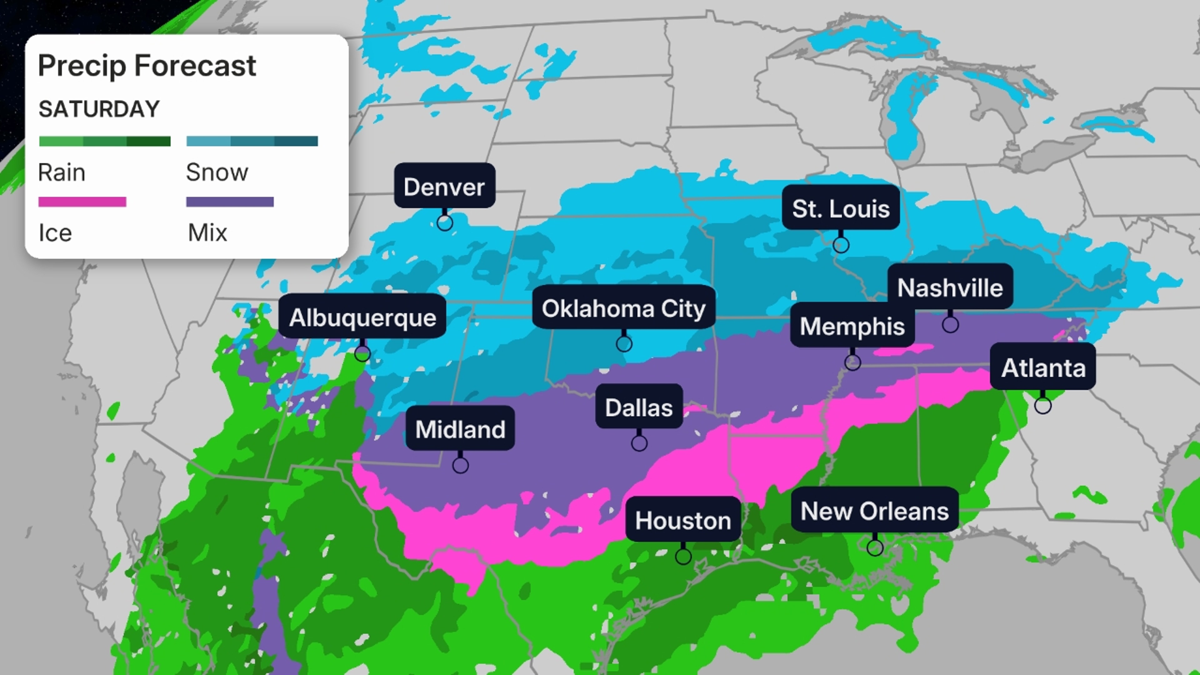
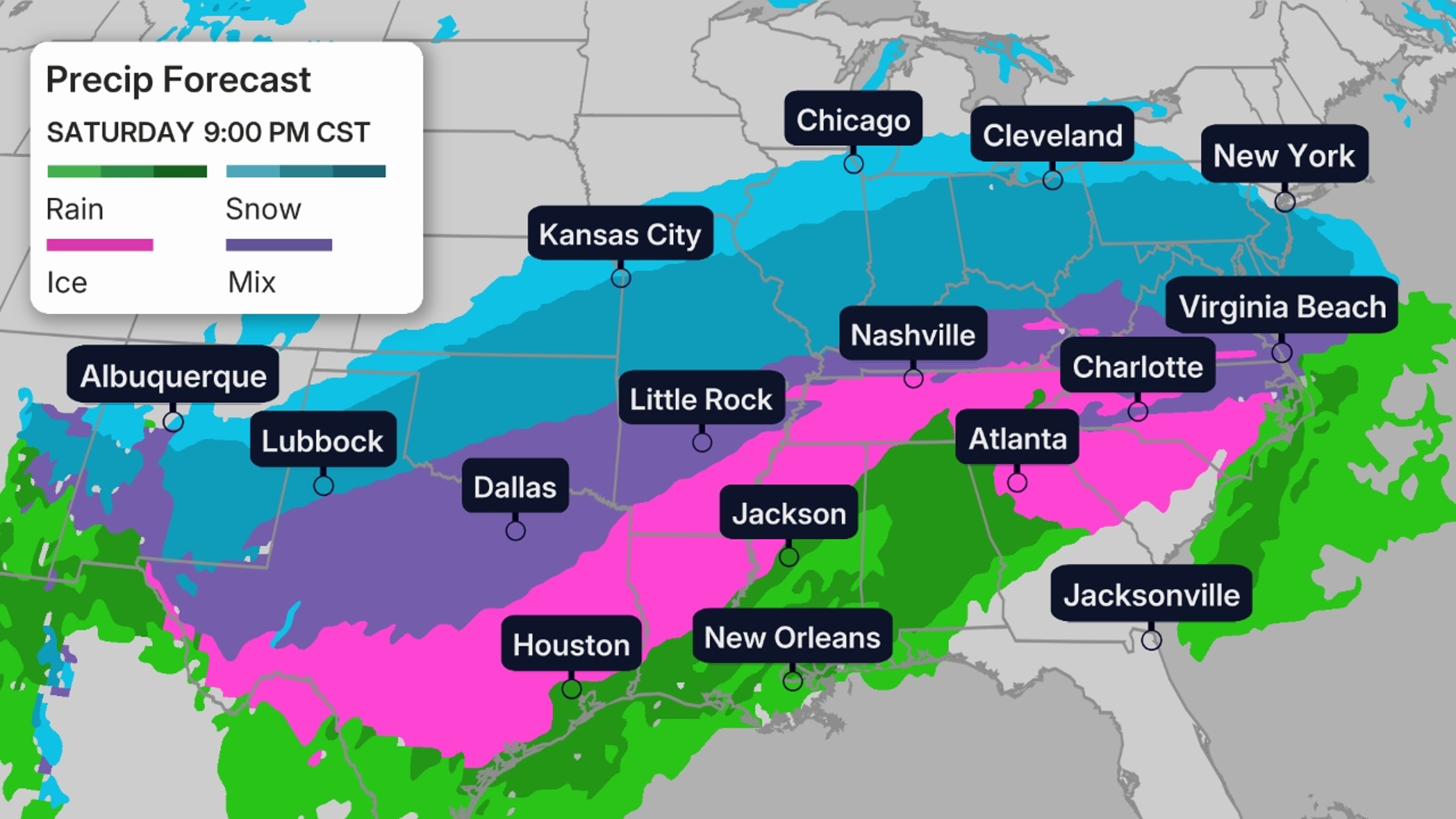
Saturday: Snow, sleet and ice will sink farther south in Texas, Louisiana, Mississippi, while it picks up in the mid-Mississippi and Ohio Valleys, Kentucky, Tennessee, northwest Alabama, West Virginia, Virginia, parts of the Carolinas and perhaps far northern Georgia.
Cities: Albuquerque, Lubbock, Oklahoma City, Dallas, Austin, Little Rock, Shreveport, Memphis, Nashville, Knoxville, Asheville, Roanoke, Kansas City, St. Louis, Louisville, Indianapolis, Cincinnati
Saturday night: This wintry mess of ice and sleet will sag even farther south toward parts of southeast Texas, southwestern Louisiana and Mississippi, while intensifying from southern Virginia to parts of the Carolinas and northeast Georgia. Snow will spread into the mid-Atlantic states and intensify while continuing farther west in the Ohio Valley, mid-Mississippi Valley, Ozarks and parts of Oklahoma, Texas and New Mexico. Some snow may fall as far north as parts of the southern Great Lakes.
Cities: Lubbock, Houston, San Antonio, Austin, Dallas, Oklahoma City, Little Rock, Shreveport, Jackson, Memphis, Nashville, Knoxville, Atlanta (especially northeast metro), Charlotte, Raleigh-Durham, Greenville-Spartanburg, Richmond, Washington, D.C., Baltimore, Pittsburgh, Philadelphia, Kansas City, St. Louis, Chicago, Indianapolis, Louisville, Cleveland, Cincinnati
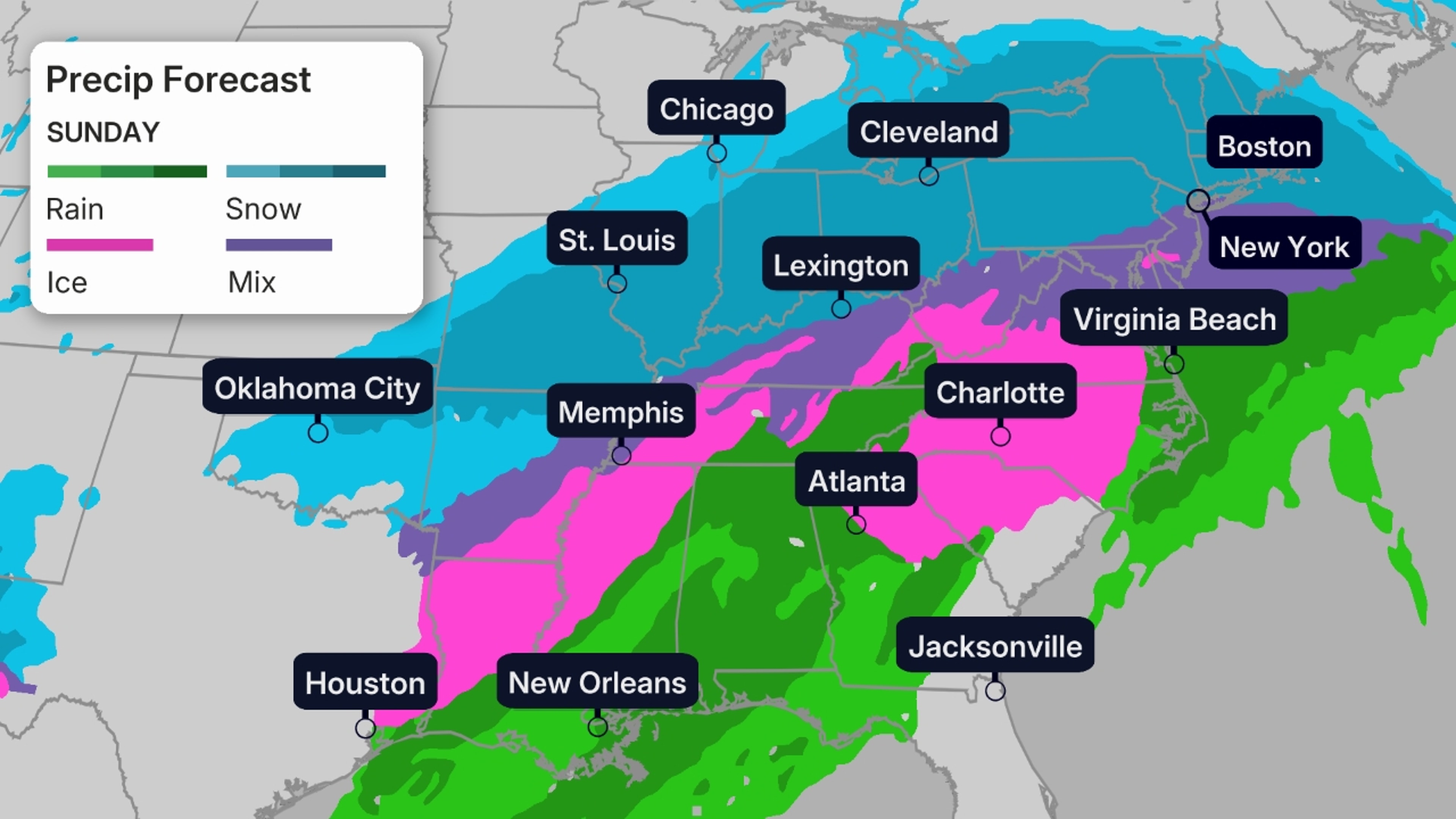
Sunday: Wintry precipitation will end in Texas, Oklahoma and most of the lower Mississippi Valley by midday, but will persist in the Great Lakes, Ohio Valley, piedmont of Virginia and the Carolinas and the Northeast. Heavy snow is likely in the Northeast and Ohio Valley. Rain and thunderstorms, some of which could be strong, will rumble across parts of the Deep South.
Cities: Houston, Oklahoma City, Little Rock, St. Louis, Chicago, Shreveport, Jackson, Memphis, Nashville, Indianapolis, Louisville, Cincinnati, Cleveland, Atlanta (especially northeast metro), Greenville-Spartanburg, Charlotte, Raleigh, Richmond, Washington, D.C., Baltimore, Pittsburgh, Philadelphia, New York City, Hartford, Boston
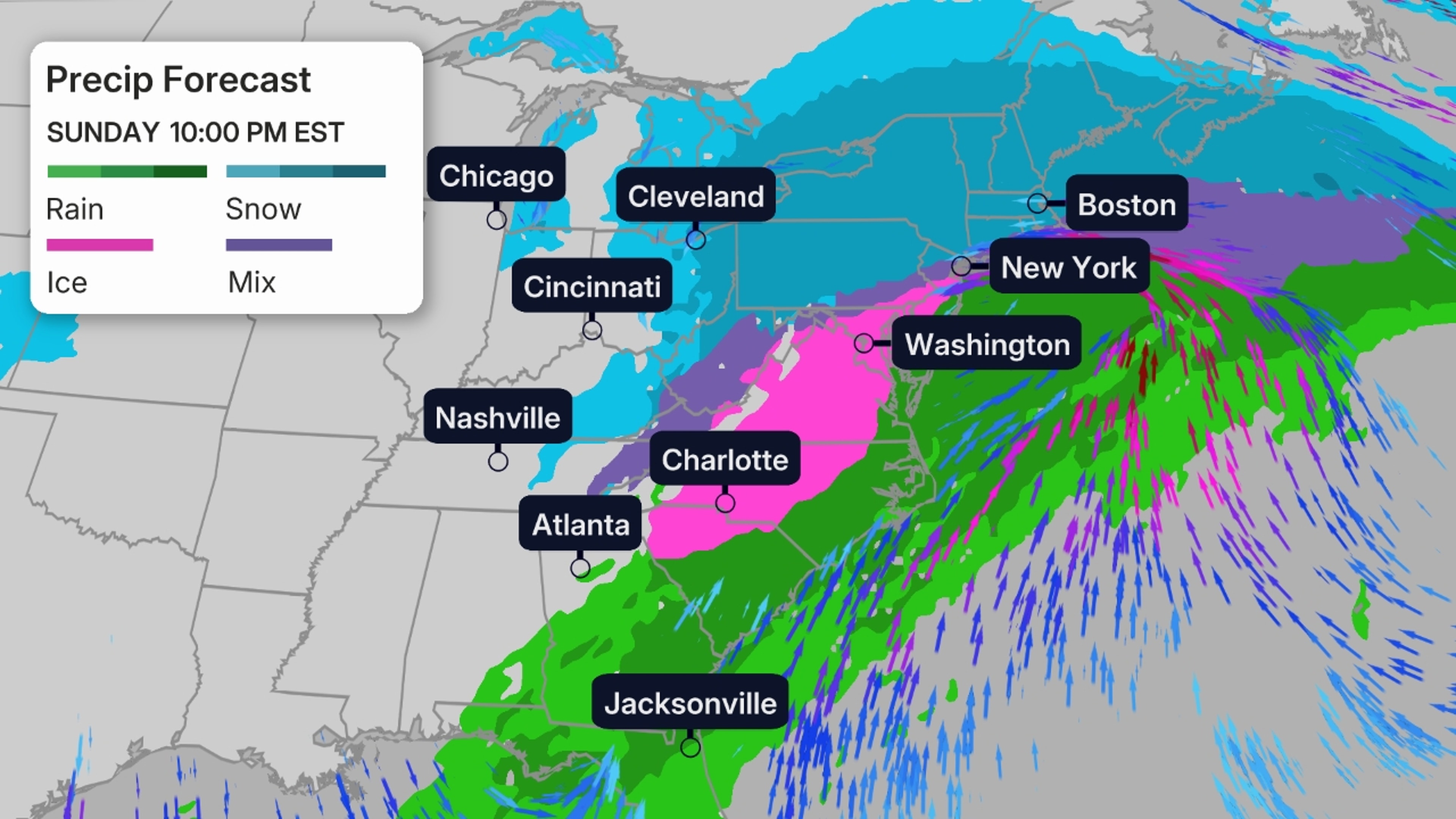
Sunday night and Monday: Snow will continue throughout much of the Northeast, but could mix with sleet, ice or change to rain near the coast from southern New England and Long Island to the Delmarva Peninsula as a nor’easter moves along the East Coast.
Snow may also linger in the Great Lakes, Ohio Valley and Appalachians. Areas of sleet and/or freezing rain may also linger in parts of Virginia and the Carolinas before either changing to rain or ending before sunrise Monday morning.
Some snow is expected to linger in parts of the Northeast, especially New England and upstate New York, on Monday, along with some gusty winds as the nor’easter gradually moves away.
Rain and thunderstorms may rumble across parts of the Southeast from the Florida Panhandle to parts of Georgia and the Carolinas.
Cities: Louisville, Cleveland, Greenville-Spartanburg, Charlotte, Raleigh-Durham, Richmond, Washington, D.C., Baltimore, Pittsburgh, Philadelphia, New York City, Hartford, Boston
 When Will It Thaw Out?
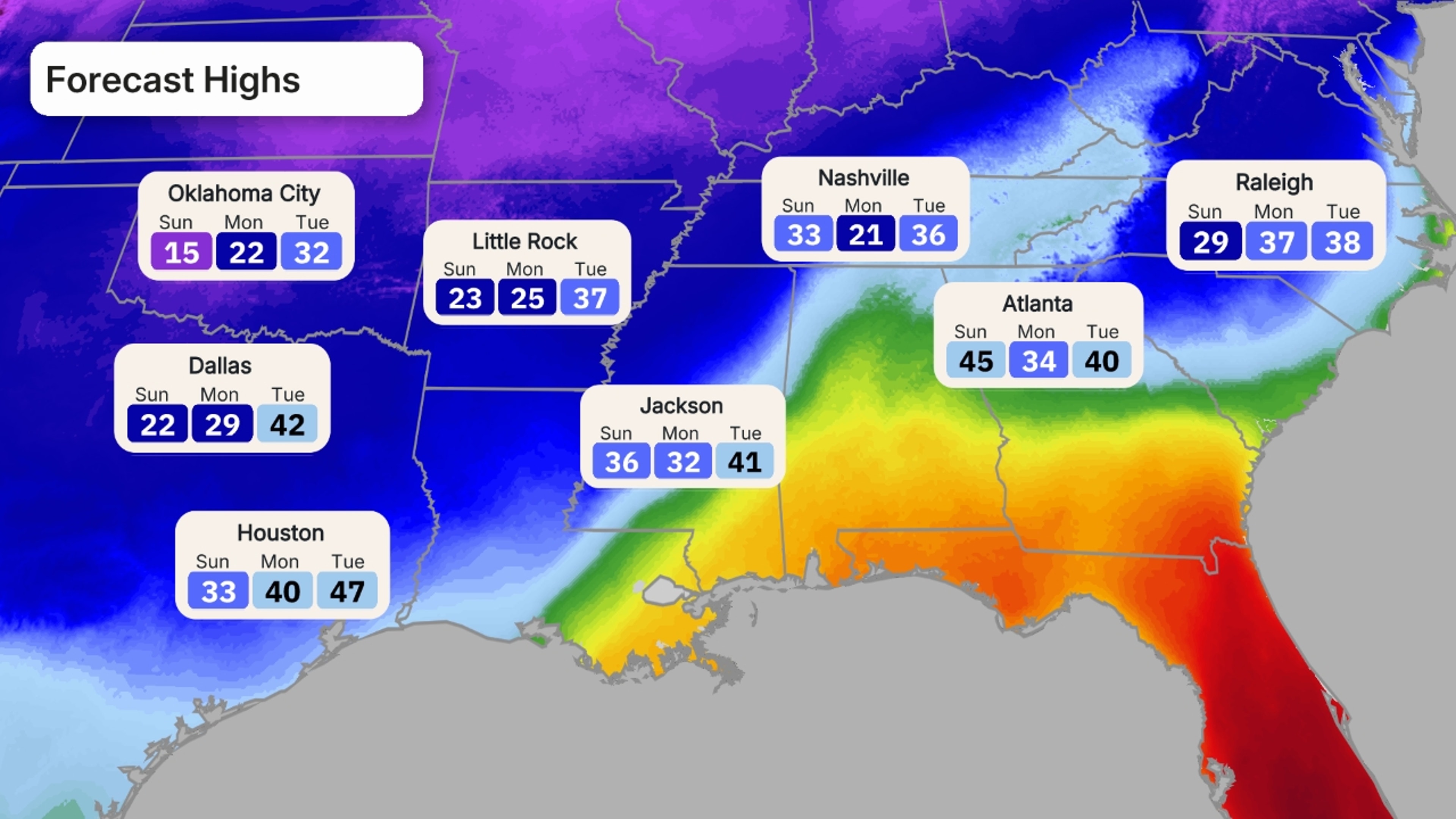
Compounding and prolonging the impacts from the storm is a strong push of cold arctic air that will threaten many daily cold records across parts of the South, Midwest and East.
Once the storm is over, daytime highs might not climb above freezing until Tuesday or Wednesday in areas covered with ice or snow in the South. And morning lows may plunge into the single digits, teens and 20s in these affected areas through Tuesday or Wednesday.
This could leave those without power shivering long after the storm. We have important tips on how to cope with a winter power outage here and here.
While increasing sunshine should help thaw some snow or ice during the day, plunging temperatures after sunset may lead to refreezing on roads and several days of slippery travel into early next week.