

Scientists have now shown they can track such uncontrolled re-entries not with telescopes or radar, but by listening to the thunderous sonic booms the debris produces. It’s a novel approach that offers a new way to monitor the unpredictable return of space junk, and it may arrive just in time.
As the number of satellites and discarded rocket stages in orbit continues to climb, so does the frequency of atmospheric re-entries. These events can be difficult to predict and even harder to track as they unfold, especially once spacecraft begin disintegrating and falling in unpredictable patterns.
The new method, developed by researchers Benjamin Fernando of Johns Hopkins University and Constantinos Charalambous of Imperial College London, relies on existing seismic networks to record the acoustic shockwaves produced by re-entering debris, offering a near-real-time view of the descent path, breakup process, and ground impact zone.
It’s a surprisingly effective system, and one that makes use of thousands of seismic stations already deployed across the planet. During the Shenzhou-15 event, for instance, 127 of these sensors in California and Nevada captured the passing shockwaves in detail.
Seismic Sensors Capture What Radars Miss
Traditional tools like radar and optical tracking often fail when it comes to fast-falling objects. According to Science, part of the problem lies in the physics of re-entry itself: as spacecraft plummet into the atmosphere, the air around them becomes ionized, forming a plasma sheath that disrupts radar signals. The result is a blackout zone where tracking becomes unreliable or even impossible.
Seismic data, on the other hand, remains unaffected. As explained by Fernando in an interview published by ZME Science, “We realised that the same can be done to track space debris after the Shenzhou-15 re-entry in California in April 2024.” Fernando had previously worked on detecting meteoroids using similar methods on Mars during NASA’s InSight mission.
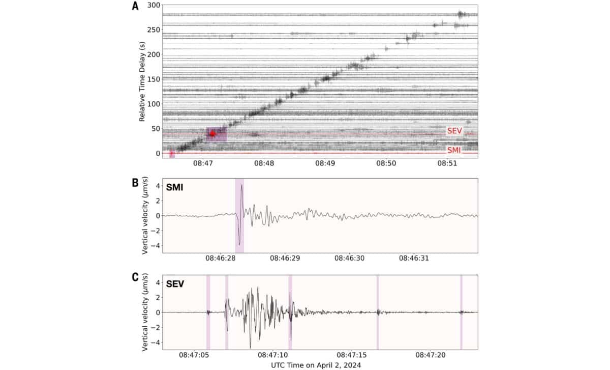 Seismic records from 124 stations show sonic boom signals during Shenzhou-15 reentry; distinct N wave at San Miguel (SMI) and complex, fragmented signals at Searles Valley (SEV). ©Science
During the April event, the Shenzhou-15 module (about 1.5 metric tons in mass) entered Earth’s atmosphere at speeds between Mach 25 and 30. As it raced over Santa Barbara and headed toward Las Vegas, the module produced a sequence of sonic booms. These shockwaves propagated downward and across the ground, where seismic stations picked them up. By studying the arrival times of these booms at various locations, the researchers were able to reconstruct the debris path with unexpected accuracy.
Their findings revealed that the real trajectory of the debris was roughly 8,600 kilometers away from the original U.S. Space Command prediction. That difference is far from trivial: it highlights the challenge of tracking re-entries using orbital projections alone, especially for objects that burn up over densely populated regions.
Disintegration Patterns and Radioactive Risk
The research also sheds light on how spacecraft fall apart during re-entry. According to Science, the team identified a clear fragmentation pattern in the seismic signals, what they describe as a “cascading failure.” This wasn’t a sudden explosion or slow melt; instead, the module broke apart in a rapid sequence of smaller events, with fragments shedding off at intervals of 0.15 to 0.35 seconds. Each separation produced its own acoustic signature.
A particularly telling piece of data came from the San Miguel Island station, where an abrupt N wave, caused by a sudden downward force from a shockwave, was recorded. This suggested that at least part of the module remained intact at high altitude before it began to disintegrate further down its path. According to the team’s findings, the descent angle was extremely shallow (just over one degree) and the breakup occurred in a compact zone approximately 16 kilometers long.
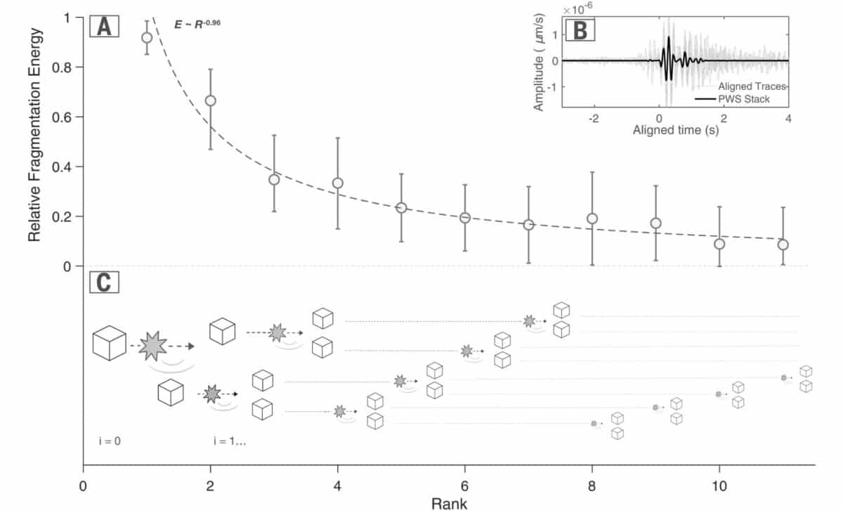 Fragmentation energy ranked by event: seismic data shows a scale-free cascade pattern with each breakup releasing less energy, consistent with a binomial fragmentation model. ©Science
This fragmentation detail has critical implications. Not all parts of a spacecraft are equal, some are designed to burn up, others are built to survive. And while most of what falls to Earth will incinerate in the upper atmosphere, not everything does. As Fernando explained in the Science report, “If you want to help, it matters whether you figure out where it has fallen quickly — in 100 seconds rather than 100 days, for example.”
In some cases, the materials involved can pose more than a structural threat. The 1996 Mars 96 mission, for instance, carried a radioactive power source that was never recovered after its failure. As Fernando noted, scientists later detected artificial plutonium in a Chilean glacier, suggesting the power source burst open during descent and scattered radioactive material across the region.
Toward Real-Time Debris Tracking
While the Shenzhou-15 study was conducted after the fact, the potential for real-time application is clear. The team believes that with further development, their seismic tracking approach could become nearly instantaneous. According to ZME Science, Fernando says that with the right data, “an automated algorithm could compute the trajectory in a few seconds.”
This would mark a significant improvement over current capabilities. Generating a trajectory using optical or radar data can take hours, if not days, and that’s assuming the object remains visible and unimpeded. The seismic method offers a parallel path that’s less affected by visibility or atmospheric interference.
The idea is not to replace other systems but to complement them, especially in areas where radar coverage is sparse. As Science reported, the researchers tested their methodology using seismic data from 124 stations in California and one in Nevada. Even stations far from the trajectory line captured acoustic signals, including weaker infrasound waves that persisted after the main sonic booms had stopped. These low-frequency sounds can travel long distances, extending the reach of the seismic network.