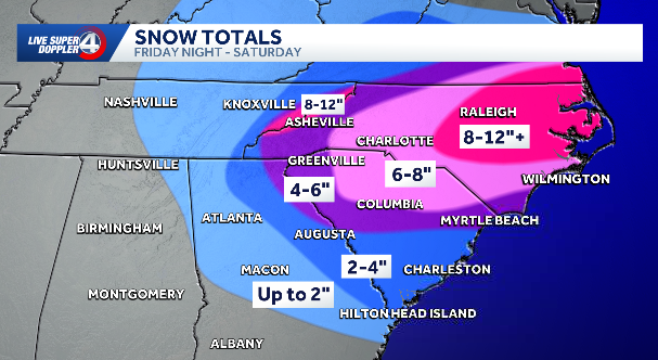
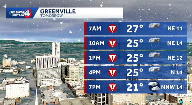
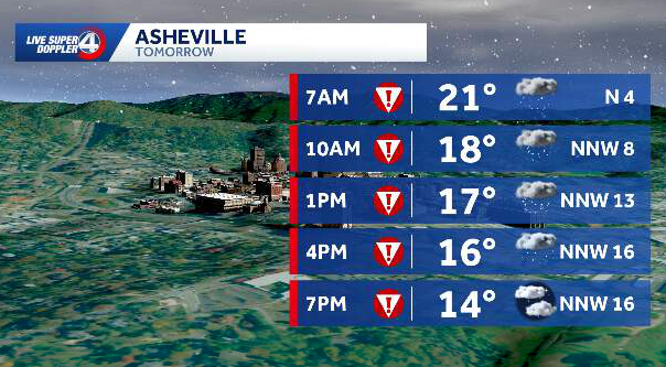
before 1am, then a chance of snow after 2am. Mostly cloudy, with a low around 22. Northeast wind 6 to 10 mph, with gusts as high as 20 mph. Chance of precipitation is 40%. Total nighttime snow accumulation of less than THIS IS A GOOD. 66. THIS IS A PRETTY GOOD BET. LAKE LURE GET CLOSER TO EIGHT INCHES. THE BIG DEAL IS GOING TO BE THE DANGEROUS TRAVEL. THE ROADS ARE GOING TO BECOME VERY TREACHEROUS FROM THE GET GO. THIS IS GOING TO TURN SLIP SLIPPERY FAST WITH THIS KIND OF SNOW ACCUMULATING TO THESE KIND OF LEVELS AND THE COLD, IT IS EQUALLY AS DANGEROUS. LOOK AT THIS SATURDAY WHEN YOU’RE OUT PLAYING, IT’S GOING TO FEEL LIKE THE TEENS GETTING INTO THE SINGLE DIGITS BY 430. KIDS NEED TO TAKE A BREAK, GO AND GET WARM. GO BACK OUT SIX DEGREES. THE FEELS LIKE TEMPERATURE AT 430 IN GREENVILLE AND IT DOESN’T STOP THERE. WE’RE UNDER AN EXTREME COLD WARNING. WE HAVEN’T BEEN THIS COLD IN A WHILE, FOLKS. -20 IN ASHEVILLE SUNDAY MORNING FOR A FEELS LIKE MINUS TWO IN SPARTANBURG. SO THE FOUR DAY PLUS LOOKS LIKE THIS. WE’VE GOT LOTS OF CHANGES COMING OUR WA
It’s the question most people are asking: When will the snow start in the Upstate area of South Carolina? Chief Meteorologist Chris Justus is offering this timeline: Friday: 5 p.m–8 p.m.: Mountain snow begins — 1–2″Saturday3 a.m.–6 a.m.: Upstate snow begins — 1″ — 24°8 a.m.: Snow spreads south — 24°11 a.m.: Heavy snow, peak of storm — 3″2 p.m.: Snow continues — 4–5″ — 23°4 p.m.: Snow showers — 5–6″ — 20°6 p.m.: Snow turns lighter — as much as 7″ — 19° (Wind chill: 8°)Sunday: Morning: 9° (Feels like: -3°)Afternoon.: Sunny 29°Monday:Morning.: Hard freeze — 11°Afternoon.: Some melting — 39°Tuesday: Morning: Refreeze — 16°Other weather resources: Alerts in your area | Closings | Radar | Maps showing temperature, winds speeds, etc. | Skycams | Live coverageAbout the WYFF News 4 weather team:The WYFF News 4 weather team has been independently certified for having the most accurate forecast in the Greenville-Spartanburg-Asheville-Anderson market for the second year in a row.“Our goal every day, in every forecast is accuracy,” said WYFF 4 President and General Manager Blake Bridges. “Our expert weather team is dedicated to giving viewers a forecast they can trust to be right. We are also the only station in the market with our own 24/7 live radar, Live Super Doppler 4. It’s clear that WYFF News 4 is the weather leader in this market.”The certification comes from WeatheRate, an independent research firm that tracks forecasts from every station in multiple markets across the country.“Everyone knows that forecasting the weather around here is difficult with the Upstate and mountains,” said WeatheRate President Bruce Fixman. “The station that gets the forecast right more than anyone else is Chief Meteorologist Chris Justus and the WYFF News 4 weather team.”Meet the Team: Chief Meteorologist Chris Justus Meteorologist Victoria Kokinos Meteorologist Bradford Ambrose Meteorologist Grace Lowe
GREENVILLE, S.C. —
It’s the question most people are asking: When will the snow start in the Upstate area of South Carolina?
Chief Meteorologist Chris Justus is offering this timeline:
Friday: 5 p.m–8 p.m.: Mountain snow begins — 1–2″Saturday
3 a.m.–6 a.m.: Upstate snow begins — 1″ — 24°8 a.m.: Snow spreads south — 24°11 a.m.: Heavy snow, peak of storm — 3″2 p.m.: Snow continues — 4–5″ — 23°4 p.m.: Snow showers — 5–6″ — 20°6 p.m.: Snow turns lighter — as much as 7″ — 19° (Wind chill: 8°)

Sunday: Morning: 9° (Feels like: -3°)Afternoon.: Sunny 29°Monday:Morning.: Hard freeze — 11°Afternoon.: Some melting — 39°Tuesday: Morning: Refreeze — 16°
Other weather resources: Alerts in your area | Closings | Radar | Maps showing temperature, winds speeds, etc. | Skycams | Live coverage


About the WYFF News 4 weather team:
The WYFF News 4 weather team has been independently certified for having the most accurate forecast in the Greenville-Spartanburg-Asheville-Anderson market for the second year in a row.
“Our goal every day, in every forecast is accuracy,” said WYFF 4 President and General Manager Blake Bridges. “Our expert weather team is dedicated to giving viewers a forecast they can trust to be right. We are also the only station in the market with our own 24/7 live radar, Live Super Doppler 4. It’s clear that WYFF News 4 is the weather leader in this market.”
The certification comes from WeatheRate, an independent research firm that tracks forecasts from every station in multiple markets across the country.
“Everyone knows that forecasting the weather around here is difficult with the Upstate and mountains,” said WeatheRate President Bruce Fixman. “The station that gets the forecast right more than anyone else is Chief Meteorologist Chris Justus and the WYFF News 4 weather team.”
Meet the Team:

