
Several inches of snow expected across much of South Carolina and North Carolina
ARRAIGNMENT HEARING TOMORROW. THE RADAR RETURNS WE’RE STARTING TO SHIFT INTO NOWCASTING HERE AS WE’RE LOOKING AT WHAT’S HAPPENING BACK TOWARD THE WEST. LOOK AT SOME D.O.T CAMERAS ACROSS THE I-40 CORRIDOR GETTING BACK INTO TENNESSEE. AND THE GROUND COVER THERE. AND THEY’RE STILL ABLE TO TRAVEL ON IT, BUT IT IS STARTING TO GET COVERED THERE. AS WE LOOK BACK THROUGH NORTH GEORGIA. SAME STORY. WE’VE GOT SOME GROUND TRUTH THERE AS WE’VE HAD SOME FLURRIES AND SOME SNOW SHOWERS STARTING TO FILL IN HERE ON SCHEDULE. WINTER STORM WARNING IN EFFECT FOR EVERYBODY IN THE CAROLINAS AND GEORGIA AS THIS WINTER STORM TAKES SHAPE AND SPREADS IN ACROSS THE AREA. EVERYTHING IS PRETTY WELL ON TRACK WITH THE TIMING, THE TOTALS, THE IMPACTS ALL LOCKED IN HERE AS THIS STORM IS TAKING SHAPE NOW, IT DOESN’T MEAN IT’S NOT GOING TO THROW US CURVEBALLS. WE’RE GOING TO STAY ON TOP OF IT USING OUR TOOLS, INCLUDING OUR SKYCAM ON OUR OWN. DOPPLER RADAR HELPS US PINPOINT WHERE THAT SNOW IS FALLING, EXACTLY WHERE IT’S FALLING. YET HERE’S THE SNOW SPREADING ACROSS THE DAY TOMORROW. JUST ABOUT EVERY SQUARE INCH OF THE CAROLINAS WILL BE COVERED IN SNOW BY THIS TIME TOMORROW, AND SOME OF US WILL BE QUITE A BIT OF SNOW. LET’S LOOK CLOSER AT THOSE TOTALS, BECAUSE THEY ARE HIGHER THAN WE HAVE BEEN. KIND OF STAYING ON TOP OF THE DATA. SO EACH DAY WE’VE KIND OF LOOKED AT THE NEW DATA AND SAID, ALL RIGHT, WE NEED TO GO UP A LITTLE BIT. AND HERE WE ARE SITTING AT 4 TO 6IN. AND I THINK THAT STILL SITS PRETTY GOOD FOR MOST OF US. BUT IF THERE’S GOING TO BE AN AREA THAT MAY GET A LITTLE BIT CLOSER TO THE HIGHER END, I THINK IT COULD BE GREENVILLE TRAVELERS REST GREER INTO FIVE FORKS BACK THROUGH SPARTANBURG. THOSE AREAS COULD BE SIX PLUS INCHES. AND BY PLUS I MEAN GETTING CLOSER TO 9 OR 10. WE’LL WATCH THAT CLOSELY. BACK THROUGH THE TENNESSEE STATE LINE WE’VE GOT 8 TO 12IN OF SNOW HAS ALREADY STARTED THERE. AS YOU LOOK AT OUR SKYCAM NETWORKS, I’M LOOKING AT THE CEILING TO WE’RE STILL GOOD AND DRY IN ANDERSON. SPARTANBURG DOESN’T MEAN THAT THE SNOW FLURRIES OR FLAKES CAN’T MAKE IT DOWN. IT’S JUST THAT CEILING IS STILL PRETTY HIGH. ASHEVILLE HAS LOWERED NEAR 30 DEGREES AND IT’S SNOWING THERE. SAME STORY AT HILTON GREENVILLE. NOTICING THAT LITTLE HAZE STARTING TO GET THE SKIES, THAT CEILING STARTS TO LOWER. IT IS CURRENTLY 34 DEGREES. PLENTY COLD ENOUGH FOR THAT NORTHEAST WIND. IT’S DRIVING IN AT 17MPH. THAT ARCTIC AIR IS HERE AND BOY, IT IS GOING TO BE ARCTIC. ARCTIC. LET ME SHOW YOU AS WE GO INTO TOMORROW MORNING, 19 IN ASHEVILLE, 25 WITH SNOW WIDESPREAD ACROSS THE AREA TOMORROW, IT IS A SNOW DAY. GOOD OLD-FASHIONED SNOW DAY. WE’RE JUST CONTINUES TO SNOW HOUR BY HOUR. THOSE TEMPERATURES GOING COLDER AS THE DAY GOES ON. AND WITH THAT WIND DRIVING IN, IT IS GOING TO BE BRUTAL. AS WE LOOK TOWARD ASHEVILLE AND HENDERSONVILLE, THOSE TEMPERATURES GETTING DOWN INTO THE LOW TEENS WITH SNOW DRIVING IN AS WE GO, HOUR BY HOUR AS WELL. 28 IN GREENVILLE, 29 IN ANDERSON AND 22 IN ASHEVILLE. LATEST COMPUTER MODEL SHOWS THAT HIGH RESOLUTION MODEL SHOWING THAT SNOW SPREADING IN ACROSS THE UPSTATE. IT IS JUST RIPPING AND ROARING BY 6:00 TO 8:00. NOW FOR THE SOUTHERN PART OF THE UPSTATE. IT MAY TAKE UNTIL CLOSER TO EIGHT, BUT IT’S COMING. EVERYBODY IS GOING TO GET IT TOMORROW AND IT WILL CONTINUE TO BE HEAVY THROUGH THE AFTERNOON HOURS. BY TWO 3:00, STARTING TO PUSH TOWARD THE SOUTH. AND WE STILL GOT SOME SNOW SHOWERS ACROSS THE AREA. BUT THE MAJORITY OF THE BULK OF THE STORM IS NOW PUSHING OFF TOWARD THE SOUTH AGAIN. SOME SNOW FLURRIES, SOME SNOWFLAKES PIVOTING AROUND RIGHT HERE, AND IT WILL STILL BE COMING DOWN IN SPARTANBURG, GAFFNEY AND GREENWOOD. SNOW TOTALS LOOK A LITTLE BIT CLOSER LIKE THIS. SIX INCHES IS A GOOD BET ACROSS GREENVILLE. FIVE IN ANDERSON. AGAIN, SOME OF THOSE AREAS TOWARD THE EAST HERE, MAYBE SOME SURPRISE NINE INCHES. BUT IT’S LIKE THE SUMMERTIME. YOU’LL GET SOME SCATTERED AMOUNTS THAT ARE A LITTLE BIT HIGHER. ASHEVILLE AND HENDERSONVILLE, SAME STORY. YOU GO TOWARD THE TENNESSEE STATE LINE, THOUGH. WE’RE TALKING ABOUT ALMOST A FOOT IN SOME LOCATIONS, DANGEROUS TRAVEL AND DANGEROUS TEMPERATURES. THOSE ARE OUR TWO MAIN CONCERNS. AND LIKE BRADFORD MENTIONED EARLIER IN THE BROADCAST, THAT WIND CHILL VALUE GETS LOWER AND LOWER AS WE GO INTO TOMORROW. IT WILL FEEL LIKE SIX BY 430 MINUS TWO IN ASHEVILLE, AND THAT COLD WEATHER KEEPS FUNNELING IN BY 7 A.M. ON SUNDAY, IT’S -20 IN ASHEVILLE. LET’S LOOK CLOSER AT THAT FORECAST, BECAUSE THERE ARE SOME LINGERING IMPACTS WITH THIS. I THINK THEY’RE GOING TO HAVE SOME PROBLEMS WITH THE ROADS AND SCHOOL CLOSINGS AND WHATNOT INTO NEXT WEEK BECAUSE OF THE THAW, THE REFREEZE. WE DON’T GET ABOVE FREEZING AGAIN UNTIL MONDAY, AND THAT’S ONLY 38 DEGREES, SO YOU’LL HAVE SOME MINIMAL MELTING. THEN WE FALL DOWN TO 20 BACK UP TO 45. THAT’S WHEN WE GET SOME MEANINGFUL MELTING. AND I THINK THERE MAY BE SOME PROBLEMS ON WEDNESDAY MORNING, BUT BY THEN WE’RE STARTING TO CLIMB OUT OF THAT. AND I SEE A 50 ON THE BOARD FOR THIS TIME NEXT WEEK. THAT WILL BE NICE. AFTER A BIG CHANGE, RIGHT? HEAVY SNOW IN THE MOUNTAINS DOWN TO THREE S
Several inches of snow expected across much of South Carolina and North Carolina

Updated: 11:30 PM EST Jan 30, 2026
We are expecting several inches of snow in parts of the Upstate areas of South Carolina, as well as parts of North Carolina. A Winter Storm Warning began Friday afternoon and runs through Sunday morning. TIMING: Snow began in the mountains late Friday evening.For the Upstate, snow begins around 3 a.m.Most snow expected to fall: Roughly 6 a.m. to 2 p.m. Saturday.Snow tapers off Saturday evening.EXPECTED TOTALS: Western Upstate, Western North Carolina: Generally 4–6 inches, with locally higher amountsEastern Upstate, east through Charlotte, the Triad, Triangle, and toward coastal NC: 6–8 inches or moreExpected Totals (Wide):Expected Totals (Local):High-Res Totals (Upstate):High-Res Totals (Western North Carolina):TEMPERATURES:Saturday highs look to stay in the teens in the mountains and low 20s in the Upstate, with single-digit temperatures possible Sunday morning. Wind chills as low as -25 in the mountains and -5 in the UpstateArctic air remains in place; we don’t get above freezing until Monday 1 p.m. Refreeze Tuesday a.m., and maybe even Wednesday.Extreme Cold Warnings:Extended forecast: Right now temperatures:Winter Alerts:Live radar: About the WYFF News 4 weather team:The WYFF News 4 weather team has been independently certified for having the most accurate forecast in the Greenville-Spartanburg-Asheville-Anderson market for the second year in a row.“Our goal every day, in every forecast is accuracy,” said WYFF 4 President and General Manager Blake Bridges. “Our expert weather team is dedicated to giving viewers a forecast they can trust to be right. We are also the only station in the market with our own 24/7 live radar, Live Super Doppler 4. It’s clear that WYFF News 4 is the weather leader in this market.”The certification comes from WeatheRate, an independent research firm that tracks forecasts from every station in multiple markets across the country.“Everyone knows that forecasting the weather around here is difficult with the Upstate and mountains,” said WeatheRate President Bruce Fixman. “The station that gets the forecast right more than anyone else is Chief Meteorologist Chris Justus and the WYFF News 4 weather team.”Meet the Team: Chief Meteorologist Chris Justus Meteorologist Victoria Kokinos Meteorologist Bradford Ambrose Meteorologist Grace Lowe
GREENVILLE, S.C. —
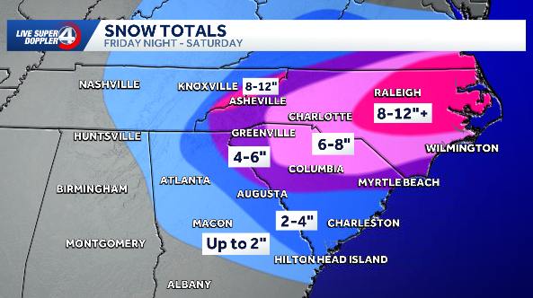
We are expecting several inches of snow in parts of the Upstate areas of South Carolina, as well as parts of North Carolina.
A Winter Storm Warning began Friday afternoon and runs through Sunday morning.
TIMING: Snow began in the mountains late Friday evening.For the Upstate, snow begins around 3 a.m.Most snow expected to fall: Roughly 6 a.m. to 2 p.m. Saturday.Snow tapers off Saturday evening.


EXPECTED TOTALS:
Western Upstate, Western North Carolina: Generally 4–6 inches, with locally higher amountsEastern Upstate, east through Charlotte, the Triad, Triangle, and toward coastal NC: 6–8 inches or more
Expected Totals (Wide):

Expected Totals (Local):

High-Res Totals (Upstate):

High-Res Totals (Western North Carolina):

TEMPERATURES:Saturday highs look to stay in the teens in the mountains and low 20s in the Upstate, with single-digit temperatures possible Sunday morning. Wind chills as low as -25 in the mountains and -5 in the UpstateArctic air remains in place; we don’t get above freezing until Monday 1 p.m. Refreeze Tuesday a.m., and maybe even Wednesday.
Extreme Cold Warnings:

Extended forecast:

Right now temperatures:

Winter Alerts:

Live radar:

About the WYFF News 4 weather team:
The WYFF News 4 weather team has been independently certified for having the most accurate forecast in the Greenville-Spartanburg-Asheville-Anderson market for the second year in a row.
“Our goal every day, in every forecast is accuracy,” said WYFF 4 President and General Manager Blake Bridges. “Our expert weather team is dedicated to giving viewers a forecast they can trust to be right. We are also the only station in the market with our own 24/7 live radar, Live Super Doppler 4. It’s clear that WYFF News 4 is the weather leader in this market.”
The certification comes from WeatheRate, an independent research firm that tracks forecasts from every station in multiple markets across the country.
“Everyone knows that forecasting the weather around here is difficult with the Upstate and mountains,” said WeatheRate President Bruce Fixman. “The station that gets the forecast right more than anyone else is Chief Meteorologist Chris Justus and the WYFF News 4 weather team.”
Meet the Team: