
Snow falls in South Carolina; several inches expected throughout the day

Updated: 4:59 AM EST Jan 31, 2026
Snow is falling across much of the Carolinas on Saturday morning with much more expected to fall throughout the day. We are also under a extreme cold warnings for dangerously low temperatures. Live updates | Live skycams | Extended forecast TIMING: Snow began in the mountains late Friday evening.For the Upstate, snow began moving in around 4 a.m. Most snow expected to fall: Roughly 6 a.m. to 2 p.m. Saturday.Snow tapers off Saturday evening.EXPECTED TOTALS: Western Upstate, Western North Carolina: Generally 4–6 inches, with locally higher amountsEastern Upstate, east through Charlotte, the Triad, Triangle, and toward coastal NC: 6–8 inches or moreExpected Totals (Wide):Expected Totals (Local):High-Res Totals (Upstate):High-Res Totals (Western North Carolina):TEMPERATURES:Saturday highs look to stay in the teens in the mountains and low 20s in the Upstate, with single-digit temperatures possible Sunday morning. Wind chills as low as -25 in the mountains and -5 in the UpstateArctic air remains in place; we don’t get above freezing until Monday 1 p.m. Refreeze Tuesday a.m., and maybe even Wednesday.Extreme Cold Warnings:Extended forecast: Right now temperatures:Winter Alerts:Live radar: About the WYFF News 4 weather team:The WYFF News 4 weather team has been independently certified for having the most accurate forecast in the Greenville-Spartanburg-Asheville-Anderson market for the second year in a row.“Our goal every day, in every forecast is accuracy,” said WYFF 4 President and General Manager Blake Bridges. “Our expert weather team is dedicated to giving viewers a forecast they can trust to be right. We are also the only station in the market with our own 24/7 live radar, Live Super Doppler 4. It’s clear that WYFF News 4 is the weather leader in this market.”The certification comes from WeatheRate, an independent research firm that tracks forecasts from every station in multiple markets across the country.“Everyone knows that forecasting the weather around here is difficult with the Upstate and mountains,” said WeatheRate President Bruce Fixman. “The station that gets the forecast right more than anyone else is Chief Meteorologist Chris Justus and the WYFF News 4 weather team.”Meet the Team: Chief Meteorologist Chris Justus Meteorologist Victoria Kokinos Meteorologist Bradford Ambrose Meteorologist Grace Lowe
GREENVILLE, S.C. —
Snow is falling across much of the Carolinas on Saturday morning with much more expected to fall throughout the day.
We are also under a extreme cold warnings for dangerously low temperatures.
Live updates | Live skycams | Extended forecast
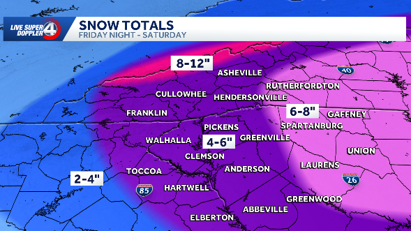
TIMING: Snow began in the mountains late Friday evening.For the Upstate, snow began moving in around 4 a.m. Most snow expected to fall: Roughly 6 a.m. to 2 p.m. Saturday.Snow tapers off Saturday evening.


EXPECTED TOTALS: Western Upstate, Western North Carolina: Generally 4–6 inches, with locally higher amountsEastern Upstate, east through Charlotte, the Triad, Triangle, and toward coastal NC: 6–8 inches or more
Expected Totals (Wide):

Expected Totals (Local):

High-Res Totals (Upstate):

High-Res Totals (Western North Carolina):

TEMPERATURES:Saturday highs look to stay in the teens in the mountains and low 20s in the Upstate, with single-digit temperatures possible Sunday morning. Wind chills as low as -25 in the mountains and -5 in the UpstateArctic air remains in place; we don’t get above freezing until Monday 1 p.m. Refreeze Tuesday a.m., and maybe even Wednesday.
Extreme Cold Warnings:

Extended forecast:

Right now temperatures:

Winter Alerts:

Live radar:

About the WYFF News 4 weather team:
The WYFF News 4 weather team has been independently certified for having the most accurate forecast in the Greenville-Spartanburg-Asheville-Anderson market for the second year in a row.
“Our goal every day, in every forecast is accuracy,” said WYFF 4 President and General Manager Blake Bridges. “Our expert weather team is dedicated to giving viewers a forecast they can trust to be right. We are also the only station in the market with our own 24/7 live radar, Live Super Doppler 4. It’s clear that WYFF News 4 is the weather leader in this market.”
The certification comes from WeatheRate, an independent research firm that tracks forecasts from every station in multiple markets across the country.
“Everyone knows that forecasting the weather around here is difficult with the Upstate and mountains,” said WeatheRate President Bruce Fixman. “The station that gets the forecast right more than anyone else is Chief Meteorologist Chris Justus and the WYFF News 4 weather team.”
Meet the Team: