
Watch live WBTV News and First Alert Weather coverage in the video player above.
CHARLOTTE, N.C. (WBTV) – Snow is actively falling across the Carolinas on Saturday, and snow totals were adding up early Saturday afternoon. This is a true snow day across the Carolinas!
We’re in the middle of a significant winter storm on Saturday, Jan. 31.
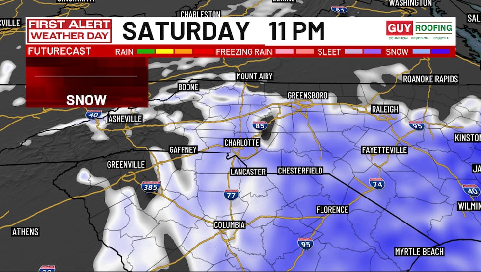
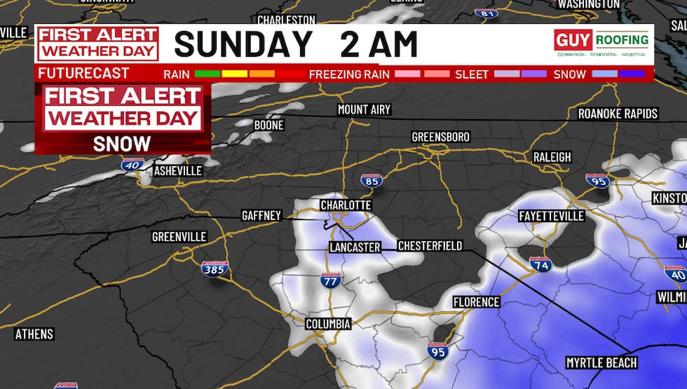
While the First Alert Weather team has made a few fine-tuned forecast updates based on radar and real-time observations, the overall forecast remains solid and unchanged: Snow totals are adding up, warnings remain in effect, and impacts will continue through Sunday morning.
Here’s a breakdown of the Carolina snowstorm forecast, as of early Saturday afternoon.
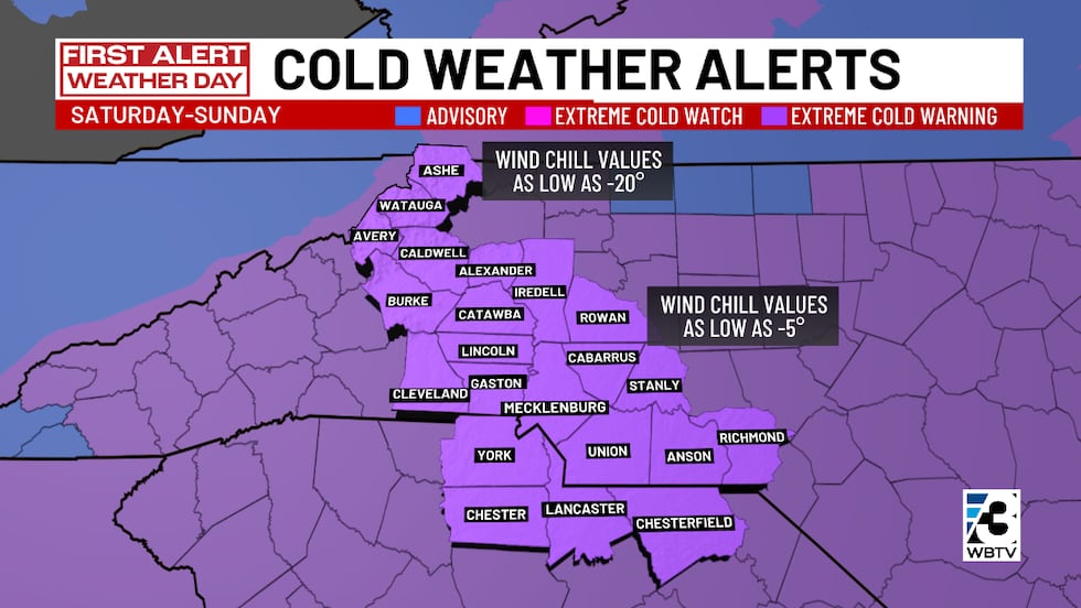
What’s changed (and what hasn’t)Snow is now well underway across the region.Snow totals have increased.Winter Storm Warning continues through 7 a.m. Sunday, Feb. 1.Extreme Cold Warning goes into effect Saturday night.Why this snow means business
This storm is being driven by an unusually strong upper-level system — one that’s much stronger than normal for this time of year.
That’s helping to create snow accumulation, even without extreme moisture in the air.
On top of that, the air is very cold, allowing snow to fall light and fluffy with high snow-to-liquid ratios.
Translation: It doesn’t take much moisture for snow to pile up quickly!
Snow totals for most areas across the Charlotte region have even been bumped up slightly as snow bands sharpen Saturday.
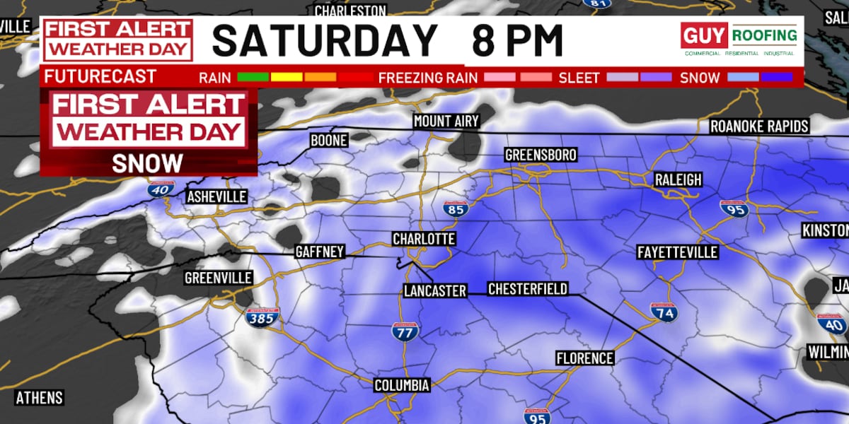
 WBTV First Alert Weather Team tracks weekend snowstorm on Jan. 31, 2026(WBTV)What to expect the rest of SaturdaySnow continues through the day with periods of heavier bursts.Snowfall rates could reach 1-inch per hour Saturday afternoon.Roads are snow-covered, even if totals vary from place to place.Gusty winds will cause blowing snow and reduced visibility.A few spots could briefly experience near-blizzard conditions.
Even locations that end up with slightly lower snow totals will still see major travel problems, because snow is sticking easily to roads and bridges.
Check out a video of this forecast below.
Snow is actively falling across the Carolinas on Saturday, and snow totals were adding up early Saturday afternoon. It’s a true snow day across the Carolinas!Cold temperatures to take over Saturday night
As the snow calms down later Saturday evening, the cold will crank up fast.
Wind chills will plunge Saturday night, and remain dangerous through Monday, Feb. 2.Frostbite can occur in a short amount of time (30 minutes).Pipes, pets, and people need protection.
This is why the extreme cold warning is in effect. It’s not just cold, it’s dangerously cold!
Click here to see active weather alerts and warnings for the region.
 WBTV First Alert Weather Team tracks weekend snowstorm on Jan. 31, 2026(WBTV)The bottom line
This is a high-impact snow event, and one many haven’t seen in over a decade. Snow is falling, totals are adding up, and travel will be difficult, if not impossible at times.
—> More: Traffic map: Tracking road conditions in Charlotte Metro amid snowstorm
If you don’t have to be on the roads, stay put and enjoy the snow. If you must travel, take it slow and be prepared.
We’ll have continuous WBTV team coverage all day and night on Saturday, tracking snow totals, road conditions, and the bitter cold.
I’ll keep walking you through what we’re seeing in real time, so keep checking back — and be sure send us your snow photos and videos! You can do that below.
 WBTV First Alert Weather Team tracks weekend snowstorm on Jan. 31, 2026(WBTV)Upload your weather pictures, videos
Share your photos or videos of the winter weather to the QCit album below, and we may feature them on TV or online. Be sure to note what city, town, or village the photo was taken in.
Download the free WBTV Weather app on your mobile device to receive weather alerts and to get the latest forecast on the go. You can also catch the latest forecast on WBTV’s streaming app — find it in the app store on your smart TV or streaming device.
Copyright 2026 WBTV. All rights reserved.