
As we enjoy the beautiful views of a winter wonderland across North Carolina, sunshine has returned, and the melting begins. Cold arctic air and gusty winds will keep the Piedmont in a deep freeze through early Monday, but afternoon highs will be above freezing.GROUNDHOG DAY Happy Groundhog Day!The weather, as we all know, is determined by a small groundhog in Pennsylvania (kidding). We’re watching Punxsutawney Phil this morning as he makes his famous prediction on whether winter sticks around for six more weeks or if an early spring is on the way.If Phil sees his shadow, tradition says we stay locked in a cold winter pattern. If he doesn’t, it means an early spring could be ahead. What did Phil see? SHADOWTRAVEL CONDITIONS Roads are continuing to gradually improve as NCDOT crews work around the clock to clear priority routes. Drivers should still use caution, especially during the morning hours, as melting snow can refreeze and create areas of black ice.Sidewalks and driveways may remain slick as well. Ice from last week’s storm is still present beneath lingering snow, though above-freezing temperatures this week should help improve conditions over time.WATCHING MIDWEEK RAINCold rain is expected across the Triad late Tuesday into Wednesday. While temperatures will stay too warm for additional snow, the rain could add stress to already strained infrastructure and create slick spots, particularly during the early morning commute. As this system makes its way through the Triad, the air temperature cools, which could cause intermittent flurries for some. SNOW TOTALSRecord-breaking snowfall fell during the winter storm on Saturday and Sunday. Check the highest snow totals below, or check the full list of snow totals here.PIEDMONTFOOTHILLSMOUNTAINSExtreme Cold AlertsCurrent temperatureCurrent wind chill temperatureWind chill temperatures may dip to near zero for several hours on Monday morning in the Piedmont Triad, Foothills and Mountains. Please be sure to cover all exposed skin to avoid frostbite and hypothermia if you must be outdoors during the extreme cold warning hour; wind chill values are forecast to drop as low as 25 degrees below zero in the Mountains and as low as five degrees below zero in the Foothills and Piedmont Triad.How wind chill brings the risk of frostbite and hypothermia Here’s an estimate of snowfall distribution from Saturday’s big snowstorm over the Carolinas Piedmont Triad forecast this weekFoothills forecast this weekMountains forecast this weekMore weather coverage: Weather Alerts | Closing and delays | Latest weather forecast | Post pictures to the uLocal North Carolina Facebook Group | Traffic information | Report closings and delays | SkyCams | Download the WXII12 News mobile app
WINSTON-SALEM, N.C. —
As we enjoy the beautiful views of a winter wonderland across North Carolina, sunshine has returned, and the melting begins. Cold arctic air and gusty winds will keep the Piedmont in a deep freeze through early Monday, but afternoon highs will be above freezing.
This content is imported from Twitter.
You may be able to find the same content in another format, or you may be able to find more information, at their web site.
GROUNDHOG DAY
Happy Groundhog Day!
The weather, as we all know, is determined by a small groundhog in Pennsylvania (kidding). We’re watching Punxsutawney Phil this morning as he makes his famous prediction on whether winter sticks around for six more weeks or if an early spring is on the way.
If Phil sees his shadow, tradition says we stay locked in a cold winter pattern. If he doesn’t, it means an early spring could be ahead.
What did Phil see? Stay tuned.
This content is imported from Twitter.
You may be able to find the same content in another format, or you may be able to find more information, at their web site.
TRAVEL CONDITIONS
Roads are continuing to gradually improve as NCDOT crews work around the clock to clear priority routes. Drivers should still use caution, especially during the morning hours, as melting snow can refreeze and create areas of black ice.
Sidewalks and driveways may remain slick as well. Ice from last week’s storm is still present beneath lingering snow, though above-freezing temperatures this week should help improve conditions over time.
This content is imported from Twitter.
You may be able to find the same content in another format, or you may be able to find more information, at their web site.
ROAD CONDITIONS:
Highways have been cleared pretty well, but two-lane/secondary roads are still snow-covered and icy.
Give yourself plenty of time and take it slow on your way back to work this morning.
If you can make it out of your neighborhood, you may be in good shape! pic.twitter.com/cxctIDhnC9
— Dylan Hudler (@DylanHudlerWXII) February 2, 2026
WATCHING MIDWEEK RAIN
SNOW TOTALS
Record-breaking snowfall fell during the winter storm on Saturday and Sunday. Check the highest snow totals below, or check the full list of snow totals here.
PIEDMONT


FOOTHILLS

MOUNTAINS

Extreme Cold Alerts

Current temperature

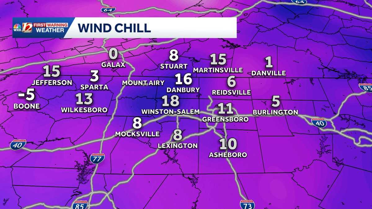
Current wind chill temperature

Wind chill temperatures may dip to near zero for several hours on Monday morning in the Piedmont Triad, Foothills and Mountains. Please be sure to cover all exposed skin to avoid frostbite and hypothermia if you must be outdoors during the extreme cold warning hour; wind chill values are forecast to drop as low as 25 degrees below zero in the Mountains and as low as five degrees below zero in the Foothills and Piedmont Triad.
How wind chill brings the risk of frostbite and hypothermia
This content is imported from Twitter.
You may be able to find the same content in another format, or you may be able to find more information, at their web site.
Here’s an estimate of snowfall distribution from Saturday’s big snowstorm over the Carolinas

This content is imported from Twitter.
You may be able to find the same content in another format, or you may be able to find more information, at their web site.
Piedmont Triad forecast this week

Foothills forecast this week

Mountains forecast this week

More weather coverage: Weather Alerts | Closing and delays | Latest weather forecast | Post pictures to the uLocal North Carolina Facebook Group | Traffic information | Report closings and delays | SkyCams | Download the WXII12 News mobile app