
The European Space Agency’s (ESA) newly launched Biomass satellite has delivered a groundbreaking false-color image of Earth’s biomass, providing a unique glimpse into the planet’s carbon stores. The satellite, designed to monitor forests, wetlands, and other carbon-rich ecosystems, has captured an astonishing image of the Beni River region in Bolivia. This detailed look at the Earth’s carbon stores offers new possibilities for tracking and understanding environmental changes, such as deforestation and climate change. As ESA embarks on this important mission, the first images are already raising expectations for the wealth of data yet to come.
The Biomass Satellite’s Groundbreaking First Images
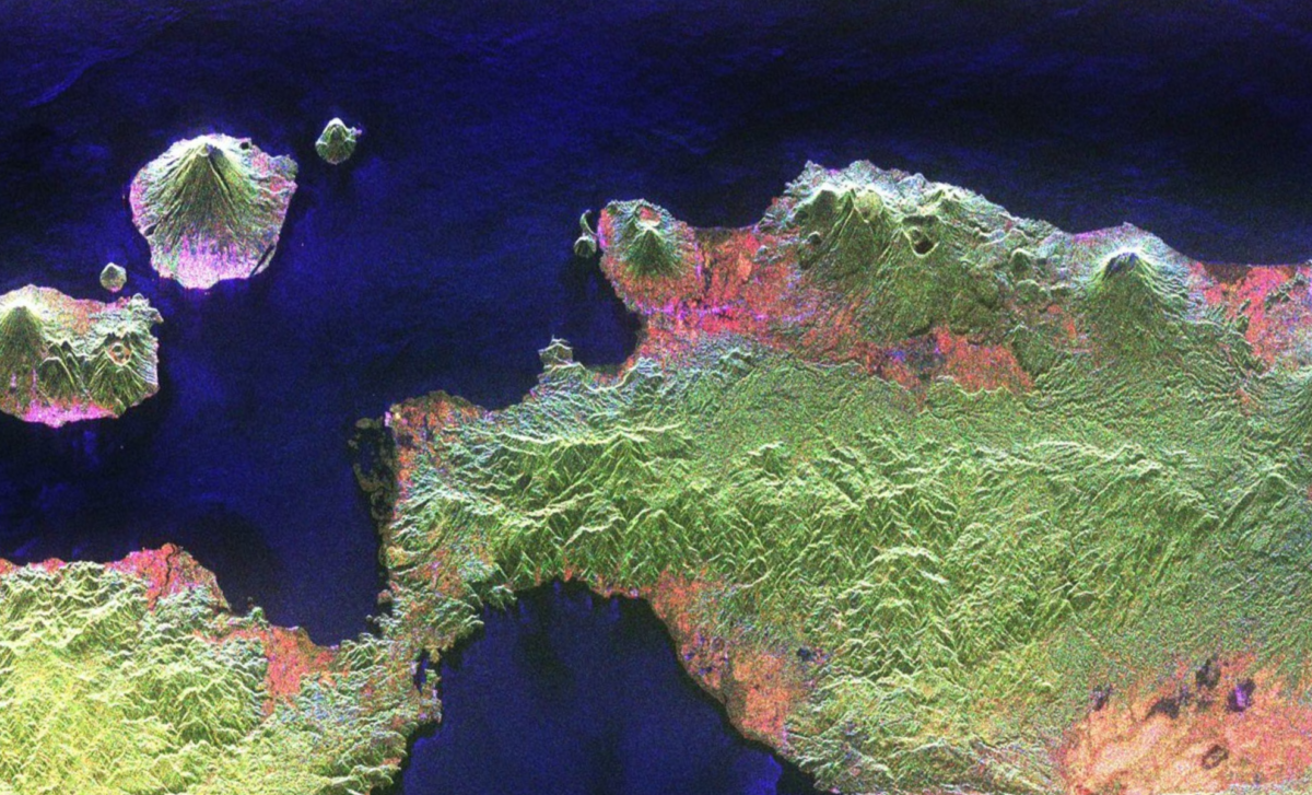
The European Space Agency’s Biomass satellite has made an impressive debut with its first images of Earth’s biomass, and the results are nothing short of spectacular. Using advanced radar technology, the satellite captures a unique, detailed view of the environment, particularly the varying levels of vegetation along the Beni River in Bolivia. The image, which uses false-color to distinguish between different types of land cover, shows rainforests in green, wetlands in red, grasslands in purple, and water in black. This new technology provides a more nuanced understanding of Earth’s carbon-rich ecosystems, which is crucial for tracking the planet’s environmental health.
Michael Fehringer, an ESA scientist and the Biomass project manager, highlighted the significance of the mission’s early results, stating,
“The mission’s first images are nothing short of spectacular — and they’re only a mere glimpse of what is still to come.”
The radar technology aboard the Biomass satellite allows for the detection of subtle differences in biomass that would otherwise go unnoticed in traditional satellite imagery. This capability is particularly important as the world faces unprecedented environmental challenges.
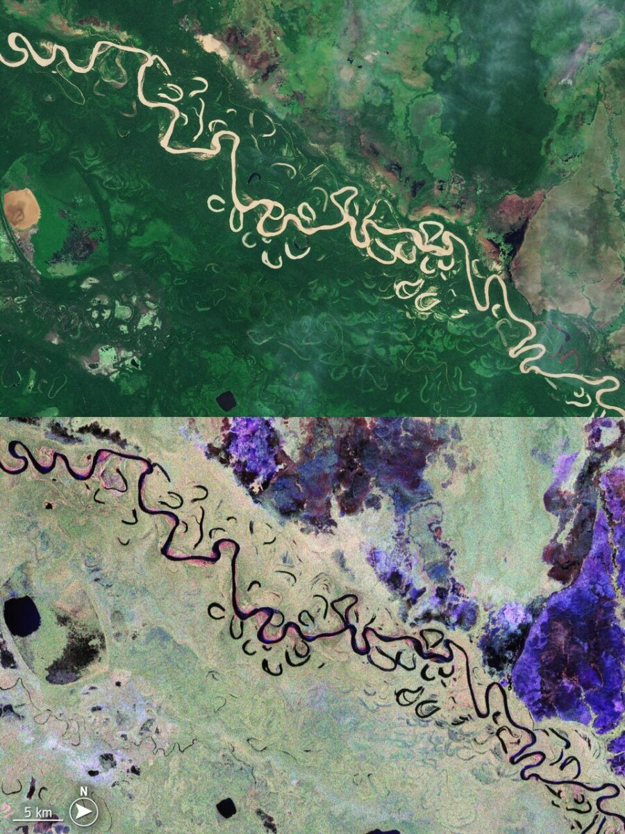 Bolivian forest: comparing Sentinel-2 and Biomass. Credit: ESA
Understanding Earth’s Carbon Storage with the Biomass Satellite
Carbon storage plays a critical role in regulating the Earth’s climate, as forests and wetlands absorb significant amounts of carbon dioxide from the atmosphere. By capturing the intricate details of these carbon-rich areas, the Biomass satellite provides invaluable insights into how human activities, such as deforestation and land-use changes, are affecting global carbon levels. As one of the most significant sources of carbon, understanding the health of forests and wetlands is essential for addressing climate change.
The Biomass satellite is equipped with radar technology that can penetrate the Earth’s surface, providing detailed data on vegetation density, forest structure, and changes over time. This ability to measure carbon storage is an important step in understanding how ecosystems are responding to climate change. “The first images are only a glimpse,” says Michael Fehringer, signaling that more in-depth data will follow as the satellite continues its mission.
The mission’s ability to track biomass across large and remote areas, such as the dense rainforests of the Amazon and the wetlands of the Beni River, is a major milestone in environmental monitoring. Through these high-resolution images, scientists can detect even subtle shifts in biomass that might otherwise go unnoticed by conventional satellites.
The Role of the Biomass Satellite in Climate Change Research
The Biomass satellite is not just a tool for monitoring Earth’s ecosystems; it is also a powerful instrument for understanding the impacts of climate change. As the world grapples with rising temperatures, changing weather patterns, and increasing deforestation, accurate data on carbon storage has never been more important. The satellite’s radar allows it to assess how different types of land cover—forests, grasslands, and wetlands—are being affected by environmental pressures.
For instance, Bolivia, one of the countries that the satellite will monitor, has seen significant deforestation in recent decades. Traditional satellite images often fail to provide the level of detail needed to quantify deforestation’s true extent, as different types of land cover often blend together. The Biomass satellite’s ability to distinguish between these types provides a more precise picture of how deforestation is altering the landscape. This is crucial for understanding the extent of human impact on carbon storage and the planet’s overall health.
ESA has made the decision to make the satellite’s data publicly available, which is expected to foster a collaborative approach to climate research. According to Simonetta Cheli, ESA’s Director of Earth Observation Programs, this open access to data will “unlock vital insights into carbon storage, climate change, and the health of our planet’s precious forest ecosystems.”
Why False-Color Satellite Images are a Game Changer for Scientists
One of the most striking features of the Biomass satellite’s imagery is its use of false-color to represent different types of land cover. This technique enhances the visibility of specific features that might be obscured in conventional satellite photos. In the image of the Beni River, for example, rainforests are shown in green, wetlands in red, and grasslands in purple. By using this method, scientists can gain a clearer understanding of how biomass is distributed across the landscape.
False-color imagery is particularly useful in areas where vegetation types are mixed or difficult to distinguish. In the past, traditional satellite photos often combined multiple types of land cover into a single, indistinguishable color. The new images from the Biomass satellite, however, enable scientists to analyze the complex relationships between different types of ecosystems. This level of detail is critical for monitoring changes in carbon storage, as different ecosystems play different roles in absorbing and releasing carbon.
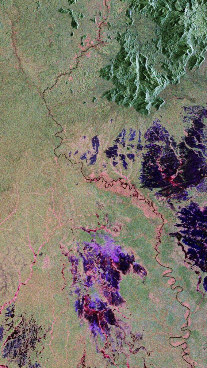 Biomass sees through rainforest. Credit: ESA
The Global Importance of Biomass Monitoring
The Biomass satellite’s mission extends far beyond the Beni River region. Over the coming years, the satellite will scan the entire planet’s forests every six months. This continuous monitoring is crucial for understanding how forests and wetlands are evolving in response to both natural and human-induced changes. By gathering long-term data, the mission will help scientists track trends in carbon storage, providing essential information for mitigating climate change.
In addition to its primary mission of monitoring biomass, the satellite will also study ice masses, offering insights into the role of frozen ecosystems in global carbon cycles. This secondary focus on ice caps and glaciers will be invaluable in assessing the impacts of melting ice on sea level rise and climate patterns. As the planet’s ice sheets continue to melt, understanding the interactions between ice and carbon will become increasingly important for predicting future climate shifts.