

Protecting the Canal neighborhood of San Rafael from the rising sea will come with significant tradeoffs and a massive price tag, according to a new report.
The sea-level rise feasibility study evaluates three adaptation strategies designed to protect the community of 12,000 for decades from being swallowed by the bay.
The options include constructing seawalls, installing flood gates or raising the land. Each presents benefits as well as drawbacks, not the least of which is the cost: $720 million to nearly $2 billion.
“We really don’t have a simple answer, or clear-cut, easy choice, otherwise it would have been done before,” Kate Hagemann, the city’s adaptation planner, said during a recent webinar. “We have some difficult considerations, and so we wanted to use this time, this study, to gather that information. It’s going to take many different types of actions over many years and by many different people.”
The Canal neighborhood, a predominantly Latino immigrant community constructed on landfill, is bound by highways on one side and bay on the other. The community has been identified as one of the more vulnerable in Marin to sea-level rise because sediment compaction is causing it to sink at an accelerated pace.
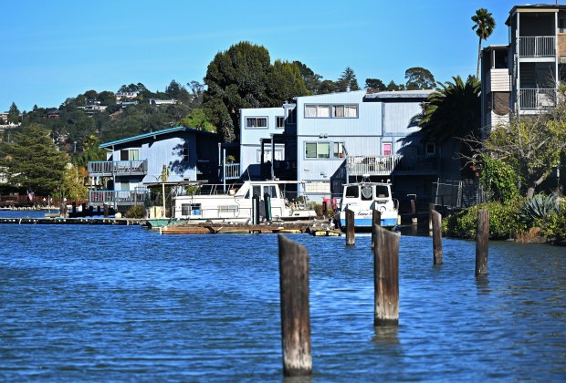 Homes sit along the water in the Canal neighborhood of San Rafael, Calif., on Wednesday, Nov. 6, 2024. (Sherry LaVars/Marin Independent Journal)
Andy Sternad, a member of a consulting firm that co-authored the report, presented an overview of alternatives.
Alternative one involves constructing seawalls along the edge of the Canal and raising the crest of bayfront levees to 14 feet. It would take about 10 to 30 years to construct and would cost about $720 million. The project would require the smallest footprint, but it will change the visual character of the waterfront and would constrain possibilities for future adaptation, Sternad said.
Alternative two would involve constructing a floodgate. The cost of the floodgate itself is estimated at about $580 million, but that does not account for the myriad bayfront adaptations needed to mitigate the environmental effects of the gate, Sternad said. This alternative is estimated to take 10 to 25 years to build.
Alternative three would involve incrementally elevating the land and redeveloping the first block of shoreline around the neighborhood. The project would cost nearly $2 billion and require property acquisition, demolition, more landfill and major redevelopment.
Alternatives one and two aim to cause the least disruption to homes and residents, maintaining the status quo, Sternad said. Alternative three would lead to displacement for some, affecting about 307 buildings.
“While Alternative 3 is the most expensive and potentially takes the most time to implement, it provides the greatest potential return on investment for long-term safety, quality of housing, habitat and waterfront access expansion, and real estate value to sustain the city’s tax base,” the report says.
Sternad said the time to act is now.
A mix of king tides and storm surges is already threatening the community with flooding. The highest tide in 2024 was 8.37 feet, and during the storms in early January, high tide was 8.7 feet in the area, Sternad said.
“These are tipping points,” Sternad said. “We’re already seeing these overtopping impacts, but they’re at the threshold of much larger impacts, overtopping, and potentially, compromising larger segments of shoreline.”
As part of the analysis, researchers examined what would happen if the city took no action and let nature take its course.
If tides reach 9 feet, there would be more overtopping water on Francisco Boulevard East and in areas on the southern side of the shoreline. If tides reach 10 feet, floodwaters will creep onto Highway 101. An 11-foot tide would spill throughout the area, with flooding lasting for days.
The report suggests some initial actions, including conducting a feasibility analysis and tidal flood response plan for the shoreline at or below the 8-foot tide threshold; implementing pilot habitat enhancement on private and public shoreline; and evaluating public acquisition of private shoreline.
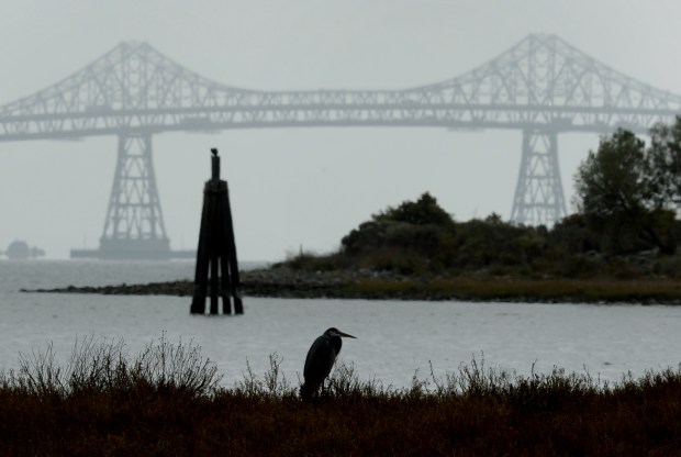 A bird on the shore of Tiscornia Marsh in San Rafael on Wednesday, Oct. 27, 2021. (Sherry LaVars/Marin Independent Journal)
Other actions include implementing the Tiscornia Marsh restoration project; maintaining and upgrading pump stations; proactively elevating critical infrastructure, such as Fire Station 54; and evaluating the feasibility of raising the road.
The study also lists environmental solutions that could be incorporated into any of the larger adaptation projects. Potential projects include reef restoration, eelgrass beds, coarse beaches, marshes and beach creation.
The study was supported by $762,000 from the State Coastal Conservancy and the Marin Community Foundation. The analysis involved hired technical consultants, community members and the nonprofit organizations Canal Alliance and the Multicultural Center of Marin.
“We’ve been working on this plan for the last two years, so huge gratitude to our staff, our partners and our community,” said Councilmember Maika Llorens Gulati, whose District 1 includes the Canal area. “This is an issue that we need everybody on board to solve.”
Cris Criollo, a climate specialist at the Multicultural Center of Marin, worked on the project. Criollo said the list of initial actions defined by the project is where planners need to start, and the community needs to be informed and engaged along the way.
“As the impacts of climate change are increasing in this area, the voices of the community are more important than ever,” Criollo said.
Omar Carrera, chief executive officer of Canal Alliance, said the $720 million to $2 billion cost reflects the scale of what is at stake, not just for one neighborhood or for San Rafael, but for the entire county.
Carrera said combining flood protection with the development of resilient workforce housing and small business spaces could unlock diverse funding sources while ensuring that the residents who are building the community are the ones who benefit from its transformation.
“We can’t afford to settle for a single-purpose seawall,” he said. “Instead, we must integrate gray engineering with green infrastructure, like new parks and restored wetlands, that protect the Highway 101 corridor and our regional economy. Crucially, this is an opportunity to do more than just defend existing assets; it is an opportunity to invest in people.”
More information is online at shorturl.at/tB6jz.