
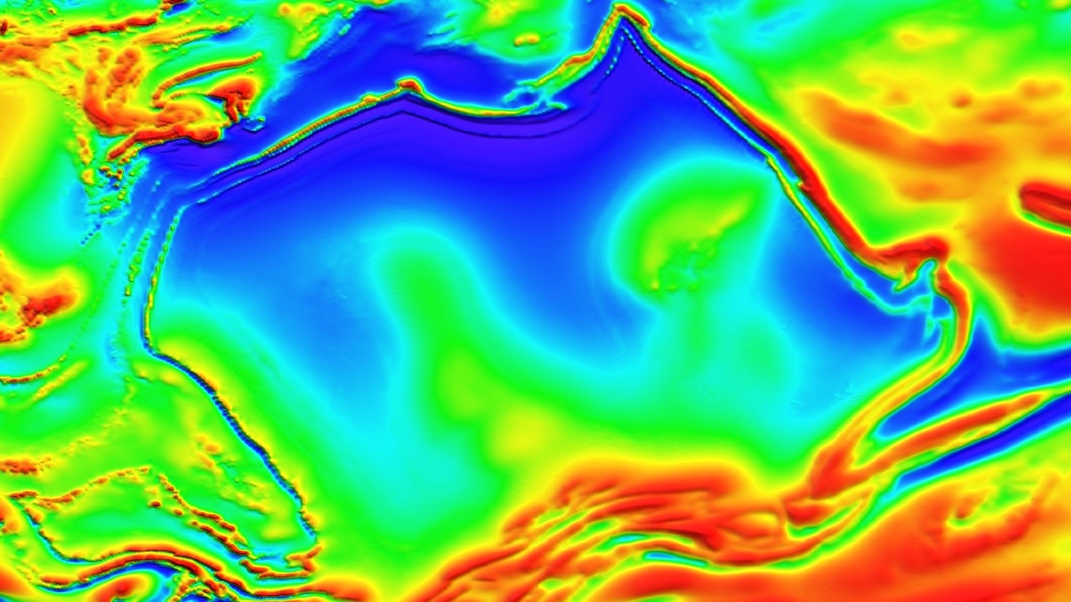
Geologists have mapped a strange magnetic anomaly in Australia – and in a stunning coincidence, it happens to look remarkably like the continent it lurks beneath.
The anomaly seems to feature its own version of Queensland’s point in the north, reaches its widest section in the middle, and has two points extending downwards on the east and west sides – all eerily reminiscent of Australia’s unique shape.
The anomaly itself is located within Australia’s Northern Territory and was imaged during an aeromagnetic survey conducted by the government. Small planes equipped with magnetometers swept back and forth over the land with a spacing of 400 meters (1,312 feet) between passes.
 An aircraft performing an aeromagnetic survey. The magnetometer is the red ball at the end of the tail. (GSSA)
This data reveals the magnetic memory, or remanent magnetization, of rocks below the surface. Essentially, when rocks form, magnetic minerals inside them become ‘locked’ in the direction that they’re currently pointing – aligned with Earth’s magnetic field.
Over millions and billions of years, the magnetic field naturally changes, as the poles drift and even completely flip. But the rocks keep a record of this history, and by measuring tiny variations in different places, geologists can see how both the magnetic field and the geology have changed over deep time.
“Magnetic data allows us to see through the ground and understand geological architecture that would otherwise remain completely hidden,” says Clive Foss, geoscientist at Australia’s government science agency, CSIRO.
“Australia’s shifting tectonic position, combined with periodic reversals of Earth’s magnetic field, means that remanent magnetization often points in unexpected directions, demanding expert interpretation.”

In this case, the so-called Australia Magnetic Anomaly springs from rocks that formed from volcanic eruptions more than 1.5 billion years ago. These layers are interspersed with sandstone from shallow seas and river deltas, and geological forces have since folded and mashed the whole structure into a shape that resembles its continental namesake.
Related: NASA Is Tracking a Vast Anomaly Growing in Earth’s Magnetic Field
The new map is the clearest yet, allowing geologists to see finer features of the underground magnetic landscape in sharper detail.
“My colleague, Dr Aaron Davis, created an innovative gridding algorithm which refined the dataset and produced cleaner, more consistent images,” says Foss.
“By improving how we process and model these datasets, we can extract more geological information than ever before.”
The data is available in an open-access database curated by Geoscience Australia, for scientists to study freely – and potentially, for valuable new mineral deposits to be identified.