
MAJOR SNOWSTORM: Hour-by-hour snow projections
AND THEN FURTHER TO THE EAST YOU CAN SEE BLIZZARD WARNINGS TOWARDS THE PHILADELPHIA METRO AREA. SO IT IS GOING TO BE A HIGH IMPACT STORM. WE’RE TALKING ABOUT THE SNOW AND THE RAIN CONTINUING AT LEAST EARLY AND THEN CHANGING OVER TO SNOW ENDING BY MONDAY. I WOULD SAY ABOUT NOONTIME IN OUR EASTERN COUNTIES AND EARLIER IN OUR WESTERN COUNTIES. SO SNOW INITIALLY WILL BE MIXING WITH SOME RAIN FOR MUCH OF THE DAY. AND THEN ONCE THE SUN SETS, THAT’S WHEN WE START TO SEE THAT MORE MODERATE AND HEAVY RAIN PICKING UP WITH ACCUMULATIONS OF 4 TO 8IN FOR MOST OF THE AREA, AND THEN 8 TO 12IN FURTHER TO THE EAST, WHICH I’LL SHOW YOU HERE IN JUST A MOMENT. ROADS WILL BE WET TO SLUSHY TODAY AND THEN THEY BECOME SNOW COVERED THIS EVENING AND OVERNIGHT. WINDS WILL ALSO BE A FACTOR AS THEY INCREASE TONIGHT AND ESPECIALLY TOMORROW. SO HERE’S A LOOK AT PREDICTOR. THIS IS AT 6:00 WHEN I REALLY EXPECT MAINLY SNOW I WOULD SAY LATE AFTERNOON. WE START TO SEE LESS MIXING MAINLY SNOW. SURFACE TEMPERATURES ARE FALLING. THAT LOW PRESSURE SYSTEM IS REALLY CRANKING OFF THE COAST. AND IT CONTINUES INTO THE EARLY MORNINGS MORNING HOURS TOMORROW. BUT NOTICE IT’S STARTING TO END IN OUR WESTERN COUNTIES. EIGHT 9:00. BUT CONTINUING IN OUR EASTERN COUNTIES. AND IT’S POSSIBLE CONTINUING UNTIL ABOUT THAT NOON HOUR. THEN SKIES WILL PARTIALLY CLEAR TOMORROW NIGHT. NOW, AS I MENTIONED, 4 TO 8IN FOR A BULK OF THE AREA. DON’T FOCUS ON THE EIGHT THOUGH. PLENTY AREAS WILL GET TO THAT FOUR INCH MARK AS WELL. 4 TO 5IN, BUT IN THAT RANGE AND THEN FURTHER TO THE EAST YOU CAN SEE HIGHER AMOUNTS WHICH WOULD CLIP PARTS OF LANCASTER C
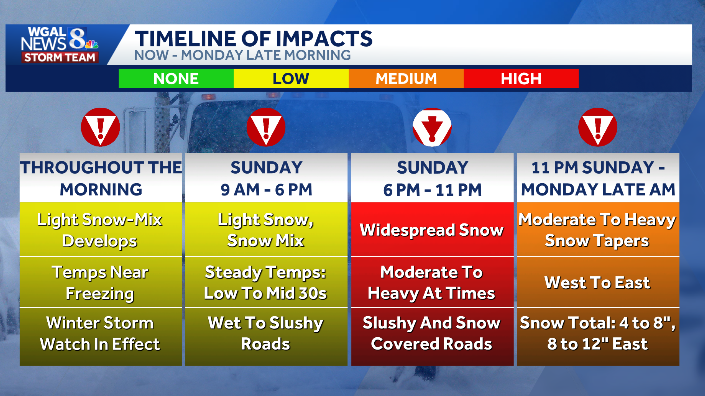
A major snowstorm is expected to hit South-Central Pennsylvania Sunday into Monday.The heaviest accumulations are expected after sunset on Sunday, with precipitation ending by Monday (noontime in eastern counties, earlier in western counties).Timing — key hoursSunday morning–late afternoon: Rain/snow mix for much of the region; mixing decreases late afternoon and evening (expecting mainly snow around 6 p.m.).Sunday night (after sunset): Moderate to heavy snow picks up with the largest accumulation window overnight into early Monday.Early Monday: Snow ending first in western counties (~8–9 a.m.) and tapering by about noon in eastern counties.Monday night: Partial clearing.Snow totals and whereMost of south‑central Pennsylvania: 4–8 inches.Lancaster, Lebanon and toward Philadelphia: Higher totals likely (8-12 inches). Many areas will be near the 4–5 inch range.ImpactsRoads will be wet to slushy on Sunday, becoming snow‑covered toward the evening and overnight.Winds increase Sunday night and especially Monday — expect blowing snow, reduced visibility and difficult travel.High‑impact storm: Plan on significant travel disruptions through Monday.What to do nowDelay nonessential travel tonight into Monday morning if possible.Allow extra time, charge devices, and secure outdoor items.
A major snowstorm is expected to hit South-Central Pennsylvania Sunday into Monday.
The heaviest accumulations are expected after sunset on Sunday, with precipitation ending by Monday (noontime in eastern counties, earlier in western counties).
Timing — key hours

Sunday morning–late afternoon: Rain/snow mix for much of the region; mixing decreases late afternoon and evening (expecting mainly snow around 6 p.m.).Sunday night (after sunset): Moderate to heavy snow picks up with the largest accumulation window overnight into early Monday.Early Monday: Snow ending first in western counties (~8–9 a.m.) and tapering by about noon in eastern counties.Monday night: Partial clearing.Snow totals and where

Most of south‑central Pennsylvania: 4–8 inches.Lancaster, Lebanon and toward Philadelphia: Higher totals likely (8-12 inches). Many areas will be near the 4–5 inch range.Impacts

Roads will be wet to slushy on Sunday, becoming snow‑covered toward the evening and overnight.Winds increase Sunday night and especially Monday — expect blowing snow, reduced visibility and difficult travel.High‑impact storm: Plan on significant travel disruptions through Monday.

What to do nowDelay nonessential travel tonight into Monday morning if possible.Allow extra time, charge devices, and secure outdoor items.