
AND THEY’RE HEADING INTO THE WEEKEND, BUT THERE WILL BE AT LEAST A FEW MORE TIMES OF WET WEATHER. NOT ONLY ARE WE SEEING SOME DRIZZLE FORMING AGAIN TONIGHT, EVEN LATER TOMORROW, A FEW MORE SHOWERS MAY DEVELOP, ESPECIALLY SATURDAY EVENING AND SATURDAY NIGHT WHERE THERE COULD BE SOME THUNDERSTORMS IN THAT. EVEN SUNDAY COULD HAVE A FEW MORE SHOWERS, BUT THE TEMPERATURES KEEP WARMING AND THEY WILL CLIMB EVEN HIGHER BY EARLY NEXT WEEK. WE WILL HAVE TO WATCH WITH ANY OF THE STORMS THAT FORM LATER SATURDAY. THEY COULD HAVE SOME DOWNPOURS, ALSO SOME LIGHTNING STRIKES, BUT ALSO A FEW MORE STRONGER WINDS. YOU CAN SEE THOSE GREEN SHADING HERE REPRESENTING WHERE ISOLATED, DAMAGING WINDS COULD FORM. NOTICE HOW IT’S MAINLY WEST OF THE BALTIMORE AREA AND THE SEVERE RISK WILL BE HIGHER THE FARTHER YOU GO TO THE WEST. RIGHT NOW WE’RE WATCHING AS SOME FOG AND DRIZZLE BREAKS OUT AGAIN. YOU CAN’T SEE IT SO MUCH IN THIS CAMERA, THOUGH YOU DO SEE A HAZE IN THE SKY HERE ON 83 NEAR YORK ROAD. AND WE’RE EXPECTING THAT FOG TO GET EVEN THICKER OVERNIGHT. BUILDING IN FROM THE WEST AND THE EAST AND KIND OF CONVERGING HERE ACROSS THE BALTIMORE AREA. SO YOU’RE GOING TO WAKE UP TO SOME DENSE FOG ON SATURDAY MORNING, AND IT COULD TAKE A WHILE FOR THAT TO SCOUR OUT MAYBE UNTIL NOON AND EVEN LATER ON THE EASTERN SHORE. AND THAT’S A BIG PART OF THE REASON WHY IT’S GOING TO STAY COOLER STILL ON SATURDAY. WE’RE STILL UNDER THAT INFLUENCE OF THAT COOL NORTHEAST WIND. SO TEMPERATURES ARE DROPPING THROUGH THE 40S OVERNIGHT TO THE UPPER 30S BY SATURDAY MORNING, WITH DENSE AREAS OF FOG AND SOME DRIZZLE INTO SATURDAY MORNING. AND THEN THE CLOUDS WILL LIFT A BIT AS WE GET INTO THE AFTERNOON. THERE MIGHT BE A BRIEF PEEK OF SUN BEFORE FEW SHOWERS ROLL IN LATE IN THE EVENING. THEY’RE STARTING OUT IN THE MOUNTAINS. A SMALL CHANCE THEY WOULD REACH HERE BEFORE THE SUN GOES DOWN. MORE LIKELY, MOST OF THEM ARE ARRIVING AFTER ABOUT 8 OR 9:00. WHEN THEY MOVE IN, THOUGH, THEY COULD STILL HAVE SOME LIGHTNING STRIKES WITH THEM AND A FEW GUSTY WINDS AND A FEW MORE OF THESE SHOWERS ARE GOING TO LAST INTO SUNDAY AS WELL. SO TONIGHT TEMPERATURES NEAR 40 DEGREES WITH AREAS OF FOG AND DRIZZLE. TOMORROW A COOLER DAY. AGAIN, NOT AS COOL AS IT WAS FRIDAY, BUT STILL COOLER THAN WHERE WE WILL BE NEXT WEEK. SO 50S AROUND BALTIMORE. BUT LOOK HOW THE WARM AIR IS ALREADY STARTING TO COME INTO WESTERN MARYLAND. A REALLY NICE DAY OUT TOWARDS OAKLAND BEFORE THOSE STORMS ARRIVE. SUNDAY WILL BE IN THE 60S, SO YOU CAN EVEN START TO SEE A WARMING TREND, THOUGH A FEW SHOWERS WILL STILL BREAK OUT ON SUNDAY, AND THERE MAY EVEN BE SOME THUNDERSTORMS SOUTH OF BALTIMORE. OUR SEVEN DAY FORECAST SO YOU HAVE TIME TO GET OUTDOORS THIS WEEKEND. IT’S CERTAINLY NOT A WASHOUT, AND EACH DAY THE TEMPERATURES KEEP CLIMBING. WE CAN REALLY LOOK FORWARD TO MONDAY WITH SUNSHINE HIGHS NEAR 70 AND WE’LL HAVE THAT LATER SUNSET BECAUSE OF THE TIME CHANGE. SO THE SUN WON’T EVEN BE GOING DOWN UNTIL ABOUT 7:00 STARTING SUNDAY EVENING. TUESDAY A WARMER DAY IN THE 70S WITH SUNSHINE STARTING WEDNESDAY. SOME MORE CLOUDS BUILD IN. THAT’S STILL A WARM DAY, BUT AT NIGHT, SHOWERS ARRIVE WITH THE NE
Showers and thunder possible later Saturday in Baltimore region
It’s not a washout this weekend, but there will be some times of rain and thunderstorms. The sunnier, warmer weather holds off a few more days.

Updated: 10:24 PM EST Mar 6, 2026
It’s not a washout this weekend, but there will be some times of rain and thunderstorms. The sunnier, warmer weather holds off a few more days.Saturday: Stay weather awareSaturday will start out gloomy with areas of fog, but there may be a few peeks of sun by the afternoon. Temperatures will warm slightly by the afternoon, into the 50s.Keep an umbrella with you for the evening, with showers possible. There’s even a slight chance for gusty thunderstorms Saturday night. Have a safety plan to get indoors if lightning approaches your area. A few of the storms could also produce strong winds. A few more showers are possible Sunday, but temperatures should still get a little milder, into the 60s.Next Week: Brief taste of summerThe warmest weather is set for next week, as the week starts with more sunshine and highs climb into the 70s. It will even start to feel a bit more humid — almost like a taste of summer.The warmer weather arrives just in time to enjoy more daylight in the evening, given the time change. Starting Sunday, the sun won’t set in Baltimore until after 7 p.m., instead of 6 p.m. That extra light in the evening will provide extra time to enjoy the warmest part of the day.Don’t worry, we’re not completely skipping seasons just yet. Temperatures are expected to drop again by the end of next week, as is typical this time of year.Stay InformedDownload the WBAL-TV 11 News app and turn on push alerts to be aware of changing weather and watch WBAL-TV 11 News for updates.Follow the WBAL-TV 11 Weather Team on X: @wbaltv11 | @TTasselWBAL | @AvaWBAL | @TonyPannWBAL | @DalenciaWBAL | @AlenaLeeWX|| Closings/Delays | Weather Advisories | Radar | Forecast | Email Alerts | Send us your pics ||WBAL-TV 11 Maryland Weather RadarApp users tap here for interactive radar.Share Your PhotosShare your weather photos and videos and we may show them on WBAL-TV 11 News or online!DIRECT UPLOAD: Use this form to upload photos and video.EMAIL: Email your photos and video to news@wbaltv.com.
BALTIMORE —
It’s not a washout this weekend, but there will be some times of rain and thunderstorms. The sunnier, warmer weather holds off a few more days.
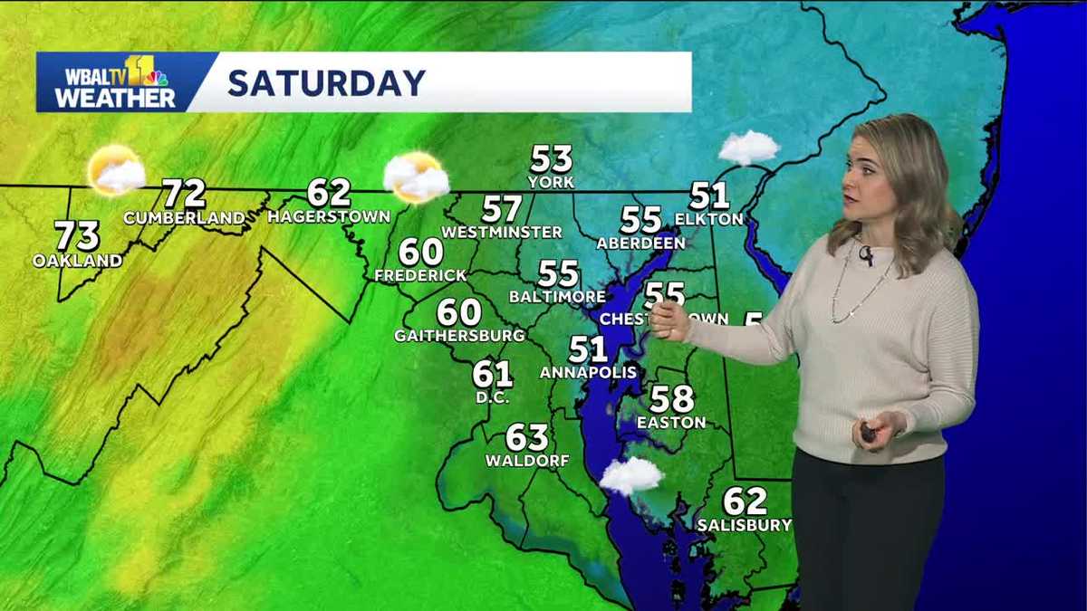
Saturday: Stay weather aware
Saturday will start out gloomy with areas of fog, but there may be a few peeks of sun by the afternoon. Temperatures will warm slightly by the afternoon, into the 50s.

Keep an umbrella with you for the evening, with showers possible. There’s even a slight chance for gusty thunderstorms Saturday night. Have a safety plan to get indoors if lightning approaches your area. A few of the storms could also produce strong winds.

A few more showers are possible Sunday, but temperatures should still get a little milder, into the 60s.
Next Week: Brief taste of summer
The warmest weather is set for next week, as the week starts with more sunshine and highs climb into the 70s. It will even start to feel a bit more humid — almost like a taste of summer.
The warmer weather arrives just in time to enjoy more daylight in the evening, given the time change. Starting Sunday, the sun won’t set in Baltimore until after 7 p.m., instead of 6 p.m. That extra light in the evening will provide extra time to enjoy the warmest part of the day.
Don’t worry, we’re not completely skipping seasons just yet. Temperatures are expected to drop again by the end of next week, as is typical this time of year.

Stay Informed
Download the WBAL-TV 11 News app and turn on push alerts to be aware of changing weather and watch WBAL-TV 11 News for updates.
Follow the WBAL-TV 11 Weather Team on X: @wbaltv11 | @TTasselWBAL | @AvaWBAL | @TonyPannWBAL | @DalenciaWBAL | @AlenaLeeWX
|| Closings/Delays | Weather Advisories | Radar | Forecast | Email Alerts | Send us your pics ||
WBAL-TV 11 Maryland Weather Radar
App users tap here for interactive radar.

Share Your Photos
Share your weather photos and videos and we may show them on WBAL-TV 11 News or online!