
There is a rare level four (out of five) severe weather risk for parts of Maryland on Monday.|| Closings/Delays | Weather Advisories | Radar | Forecast | Email Alerts | Send us your pics ||Latest radar image (*updates every 10 minutes)Severe weather\tornado riskMuch of Central Maryland will be one category short of the highest category for severe weather with a 10-15% chance of tornadoes developing.Nothing is “for sure,” but this is a fairly unusual set up for this part of the country. It is uncommon for Maryland to have a tornado risk greater than 5%.The 10% risk in Baltimore means there is a 10% chance that a tornado will occur within a 25-mile radius of any point in the affected area.TORNADO SURVIVAL: 5 things you need to do nowWhile damaging winds and tornadoes are possible for some areas in the Baltimore metro, it doesn’t mean everyone is going to see that kind of weather for sure — but it’s best to be prepared.Severe storm timeline in MarylandMeteorologist Tony Pann said the severe weather threat will be the highest in the afternoon and evening, but storms are possible from about 10 a.m. to 7 p.m. across the state.Make sure phone notifications in the WBAL-TV 11 News app for weather alerts are set to on. It will turn much colder overnight, with temperatures dropping into the 20s by Tuesday morning!Know your safe placeAs a reminder, during tornado warnings, go to a safe place in a middle, interior room of a sturdy building away from windows. The best place is in a basement, the lowest level of the building.Download the WBAL-TV app NOW and turn on push alerts to be aware of severe weather warnings, listen to NOAA Weather radio, and watch WBAL-TV 11 when impending severe weather develops.@wbaltv11 | @TTasselWBAL | @AvaWBAL | @TonyPannWBAL | @DalenciaWBAL | @AlenaLeeWXWBAL-TV 11 Maryland Weather RadarApp users tap here for interactive radar. Maryland’s 7-Day Weather ForecastAlert Days vs. Impact DaysYou may see the WBAL-TV 11 Weather Team highlight Alert Days or Impact Days in the forecasts. Here’s what that means:An Impact Day is when weather will likely disrupt your normal daily schedule or routine.An Alert Day is when there’s a threat of extreme, severe and possibly life-threatening weather. Share your weather photos and videosWhen and where safe, show us your weather photos and videos, we may show them on 11 News or online!DIRECT UPLOAD: Use this form to upload photos or video.EMAIL: Just email your photos and video to news@wbaltv.com.
BALTIMORE —
There is a rare level four (out of five) severe weather risk for parts of Maryland on Monday.
|| Closings/Delays | Weather Advisories | Radar | Forecast | Email Alerts | Send us your pics ||
Latest radar image (*updates every 10 minutes)

Severe weather\tornado risk
Much of Central Maryland will be one category short of the highest category for severe weather with a 10-15% chance of tornadoes developing.

Nothing is “for sure,” but this is a fairly unusual set up for this part of the country. It is uncommon for Maryland to have a tornado risk greater than 5%.
The 10% risk in Baltimore means there is a 10% chance that a tornado will occur within a 25-mile radius of any point in the affected area.
While damaging winds and tornadoes are possible for some areas in the Baltimore metro, it doesn’t mean everyone is going to see that kind of weather for sure — but it’s best to be prepared.

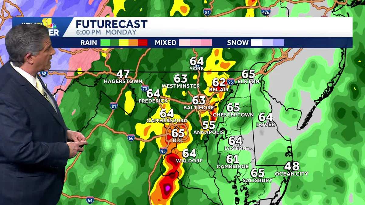
Severe storm timeline in Maryland
Meteorologist Tony Pann said the severe weather threat will be the highest in the afternoon and evening, but storms are possible from about 10 a.m. to 7 p.m. across the state.

Make sure phone notifications in the WBAL-TV 11 News app for weather alerts are set to on.
It will turn much colder overnight, with temperatures dropping into the 20s by Tuesday morning!
Know your safe place
As a reminder, during tornado warnings, go to a safe place in a middle, interior room of a sturdy building away from windows. The best place is in a basement, the lowest level of the building.
Download the WBAL-TV app NOW and turn on push alerts to be aware of severe weather warnings, listen to NOAA Weather radio, and watch WBAL-TV 11 when impending severe weather develops.
@wbaltv11 | @TTasselWBAL | @AvaWBAL | @TonyPannWBAL | @DalenciaWBAL | @AlenaLeeWX
WBAL-TV 11 Maryland Weather Radar
App users tap here for interactive radar.
Maryland’s 7-Day Weather Forecast

Alert Days vs. Impact Days
You may see the WBAL-TV 11 Weather Team highlight Alert Days or Impact Days in the forecasts. Here’s what that means:
An Impact Day is when weather will likely disrupt your normal daily schedule or routine.An Alert Day is when there’s a threat of extreme, severe and possibly life-threatening weather. Share your weather photos and videos
When and where safe, show us your weather photos and videos, we may show them on 11 News or online!