

COPYRIGHT 2026 BY CHANNEL 3000. ALL RIGHTS RESERVED. THIS MATERIAL MAY NOT BE PUBLISHED, BROADCAST, REWRITTEN OR REDISTRIBUTED.
Download the First Warn Weather app here
WHAT WE’RE TRACKING:
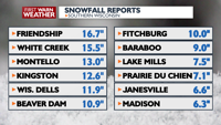
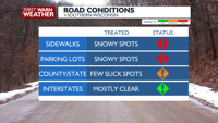
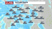
Slick travel in open/rural areas Tuesday morningAnother chance of snow Tuesday nightWarming up by the end of the week

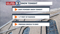
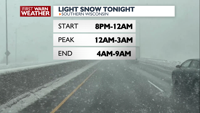
PLANNING THE NEXT 24 HOURS: Another chance for light snow returns Tuesday night but accumulations will be light, especially compared to what fell over the weekend. The snow Tuesday night wraps up early Wednesday.
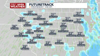
EXTENDED FORECAST: There is another chance of rain Wednedsay night into Thursday before we start to quiet down and warm up. We will be back to near 40 Wednesday, into the 50s Friday and even near 60 Saturday.

COPYRIGHT 2026 BY CHANNEL 3000. ALL RIGHTS RESERVED. THIS MATERIAL MAY NOT BE PUBLISHED, BROADCAST, REWRITTEN OR REDISTRIBUTED.
Humidity: 43%
Feels Like: 11°
Heat Index: 17°
Wind: 4 mph
Wind Chill: 11°
UV Index: 4 Moderate
Sunrise: 07:06:20 AM
Sunset: 07:06:53 PM
Dew Point: -1°
Visibility: 10 mi
Today
Partly sunny and cold. Morning wind chills near -10.
Wind: W 5-10 MPH
Tonight
Mostly cloudy and cold with scattered snow showers. Snow accumulations up to 1 inch possible.
Wind: S 8-15 MPH
Tomorrow
Variably cloudy and milder with a slight chance for snow showers early.
Wind: S 5-10 MPH
Tue
Tuesday
23°/18°
Considerable cloudiness. Highs in the mid 20s and lows in the upper teens.
Tuesday Night
Mostly cloudy and cold with scattered snow showers. Snow accumulations up to 1 inch possible.
Wind: S 8-15 MPH
Wed
Wednesday
40°/32°
Mostly cloudy. Highs in the low 40s and lows in the mid 30s.
Wednesday Night
Mostly cloudy and seasonable with scattered rain showers. Some areas may see some freezing rain or snow mix in with the rain.
Thu
Thursday
48°/33°
Mostly cloudy. Highs in the low 50s and lows in the low 30s.
Thursday Night
Mostly cloudy.
Fri
Friday
53°/36°
Mostly cloudy. Highs in the low 60s and lows in the low 40s.
Friday Night
Mostly cloudy.
Sat
Saturday
58°/36°
Times of sun and clouds. Highs in the upper 60s and lows in the low 40s.
Saturday Night
Partly cloudy with a slight chance of showers.
Sun
Sunday
47°/28°
Mix of sun and clouds. Highs in the mid 40s and lows in the low 20s.
Sunday Night
Partly cloudy and cool.
Mon
Monday
43°/28°
Mix of sun and clouds. Highs in the low 40s and lows in the upper 20s.
Monday Night
Partly cloudy and cool.
Tue
Tuesday
47°/35°
More clouds than sun. Highs in the low 50s and lows in the mid 30s.
Tuesday Night
Mostly cloudy with a chance of rain showers.
Wed
Wednesday
47°/33°
Partly cloudy. Highs in the upper 50s and lows in the upper 30s.
Wednesday Night
Mostly cloudy with a chance of rain and snow showers.
Thu
Thursday
45°/25°
Showers. Highs in the upper 40s and lows in the mid 20s.
Thursday Night
Partly cloudy skies. Low near 25F. Winds NW at 10 to 15 mph.