

COPYRIGHT 2026 BY CHANNEL 3000. ALL RIGHTS RESERVED. THIS MATERIAL MAY NOT BE PUBLISHED, BROADCAST, REWRITTEN OR REDISTRIBUTED.
Download the First Warn Weather app here
WHAT WE’RE TRACKING:
Cooler Monday, but sunny skiesMore cloud cover but warmer TuedayFew minimal shower chances this week

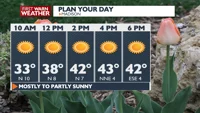
PLANNING THE NEXT 24 HOURS: Temperatures will climb back into the lower to mid 40s Monday afternoon with plenty of sunshine. Monday night clouds will increase with temperatures dropping into the lower 30s.
EXTENDED FORECAST: After an active week last week, this week does look to be relatively calmer; temperatures will climb into the 60s by Wednesday as our next system moves through the Midwest while bringing hit or miss rain showers. These rain showers will be on the lighter side. Once this system moves through, by next Friday, temperatures will cool back into the 40s for the following weekend.
COPYRIGHT 2026 BY CHANNEL 3000. ALL RIGHTS RESERVED. THIS MATERIAL MAY NOT BE PUBLISHED, BROADCAST, REWRITTEN OR REDISTRIBUTED.
Humidity: 23%
Feels Like: 40°
Heat Index: 43°
Wind: 4 mph
Wind Chill: 40°
UV Index: 4 Moderate
Sunrise: 06:55:55 AM
Sunset: 07:13:54 PM
Dew Point: 8°
Visibility: 10 mi
Today
Partly to mostly sunny and seasonable. Wind: N 5-10 MPH.
Tonight
Increasing clouds and seasonable.
Wind: S 5-10 MPH
Tomorrow
Variable cloudiness and warmer.
Wind: SW 6-12 MPH
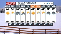
Mon
Monday
44°/31°
Sunshine. Highs in the mid 40s and lows in the low 30s.
Monday Night
Increasing clouds and seasonable.
Wind: S 5-10 MPH
Tue
Tuesday
53°/37°
Mostly cloudy. Highs in the low 50s and lows in the mid 30s.
Tuesday Night
Variable cloudiness and seasonably mild.
Wind: SW 5 MPH
Wed
Wednesday
64°/46°
Mostly cloudy. Highs in the upper 60s and lows in the upper 40s.
Wednesday Night
Mostly cloudy and mild.
Thu
Thursday
63°/28°
Mostly cloudy. Highs in the low 60s and lows in the mid 20s.
Thursday Night
Breezy with a slight chance of rain and snow showers at night, mainly early
Fri
Friday
44°/26°
Partly cloudy. Highs in the mid 40s and lows in the mid 20s.
Friday Night
Mostly clear and colder.
Sat
Saturday
49°/37°
Mostly sunny. Highs in the low 50s and lows in the mid 30s.
Saturday Night
Mostly cloudy with a chance for rain and snow showers.
Sun
Sunday
58°/42°
Partly cloudy. Highs in the upper 50s and lows in the upper 30s.
Sunday Night
Partly cloudy and seasonably mild.
Mon
Monday
61°/47°
Partly cloudy. Highs in the mid 60s and lows in the upper 40s.
Monday Night
Mostly cloudy with a chance of showers overnight.
Tue
Tuesday
67°/50°
Showers. Highs in the mid 60s and lows in the low 50s.
Tuesday Night
Mostly cloudy with scattered showers.
Wed
Wednesday
60°/52°
Chance of showers. Highs in the mid 60s and lows in the low 40s.
Wednesday Night
Mostly cloudy, breezy and mild, with scattered showers.