
BIRMINGHAM, Ala. (WBRC) – First Alert Weather Days have been declared for today and Monday for a flood threat across parts of Central Alabama. A Flood Watch is in effect through 7 p.m. CDT Monday evening. Slow-moving storms that develop over the Next 24 Hours or so could produce heavy downpours that could lead to flash flooding. Remember, if you encounter a flooded road: turn around, don’t drown!
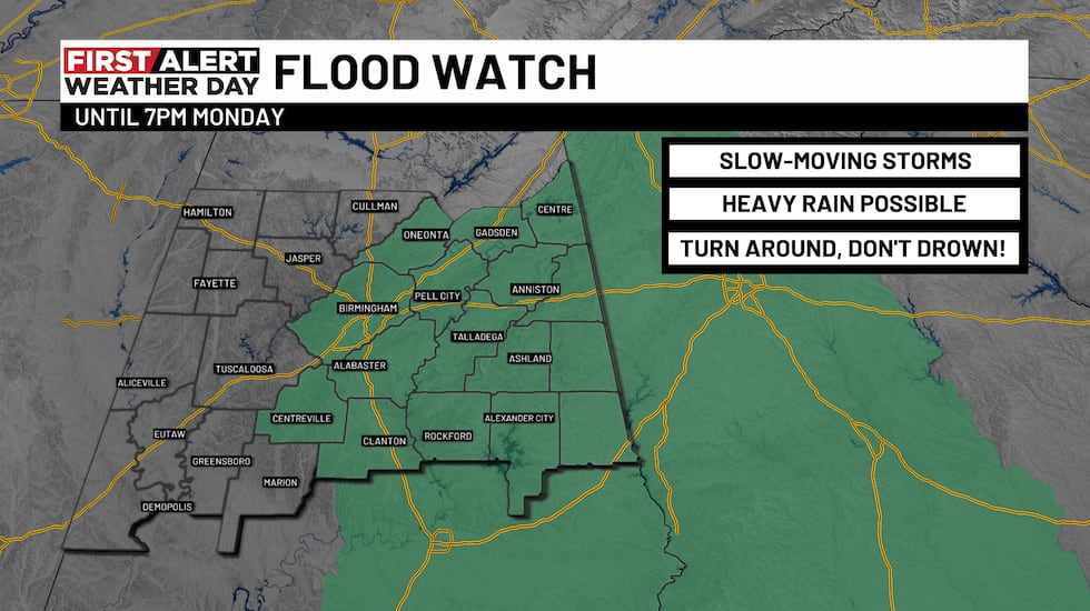 Flood Watch(WBRC)
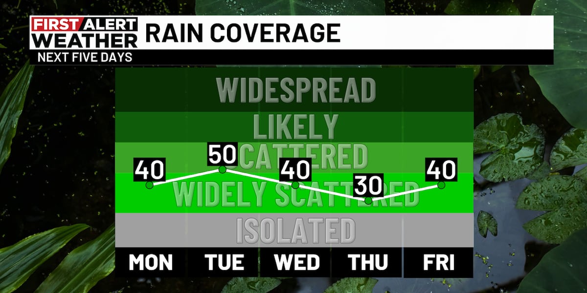
Next 24 Hours: Widely scattered thundershowers will be possible this evening, especially near the I-65 corridor, where a “backdoor” cold front has lined up. This boundary is the leading edge of the cool air wedge drifting westward across Georgia into Alabama. Temperatures only topped out in the 70s today in east Alabama but soared into the low 90s in west Alabama. More of us will reap the benefits of the wedge tomorrow as it moves farther westward. The wedge typically brings cloudy, damp, and cool conditions. Expect a mostly cloudy sky with highs in the mid to upper 70s for much of our area tomorrow. Counties closer to the Mississippi State Line will likely climb into the 80s with more breaks of sunshine and less influence from the wedge. Rain chances remain at 40% for tomorrow.
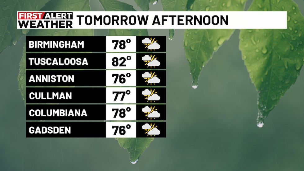 Tomorrow Afternoon(WBRC)
The Week Ahead: The wedge of cooler air will bring a nice cooldown across Central Alabama for the start of the week. High temperatures will top out in the upper 70s to low 80s again on Tuesday. Widely scattered showers and storms could develop again on Tuesday. Any heavy downpours could produce flash flooding. Rain chances likely will taper off to 30-40% for the rest of the week under a mix of sun and clouds. A good 1-2 inches of rain will be possible east of I-65 this week with lower totals to the north and west. The cool air wedge will eventually retreat, and temperatures will rebound into the mid to upper 80s later in the week. Still though, the weather pattern features below average temperatures over the next seven days. We’ll take it!
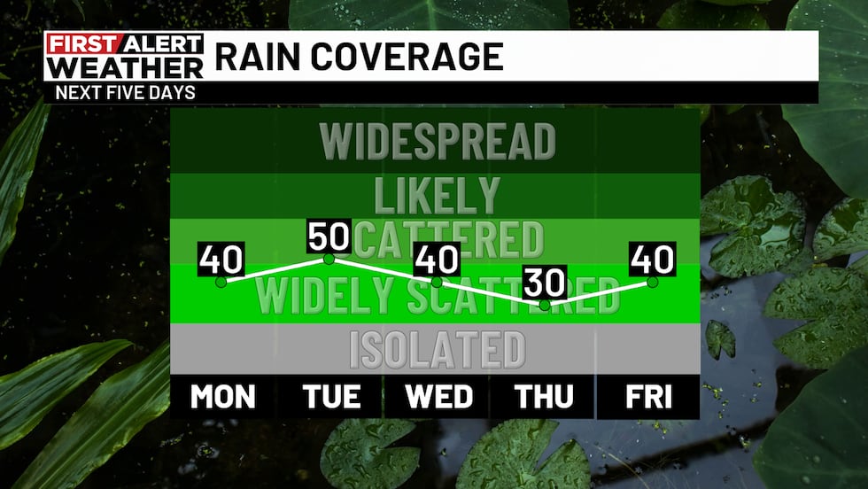 Rain Coverage(WBRC)
Tropical Update: The National Hurricane Center has outlined the potential for an area of low pressure to develop off the coast of the Carolinas soon. If a system were to develop, it would likely move out into the Atlantic, so we expect no local impacts here in Alabama; however, the disturbance could pose a rip current threat to the Eastern Seaboard. Another tropical wave could move off the west coast of Africa later this week and potentially develop on its trek across the Atlantic. We don’t see any imminent threats for the Gulf Coast with that disturbance either. An additional area of low pressure could develop off the Southeast Coast later this week, but uncertainty is high regarding future impacts and development. Nevertheless, we are moving toward the more active part of hurricane season, so we’ll keep a close eye on things in the weeks ahead.
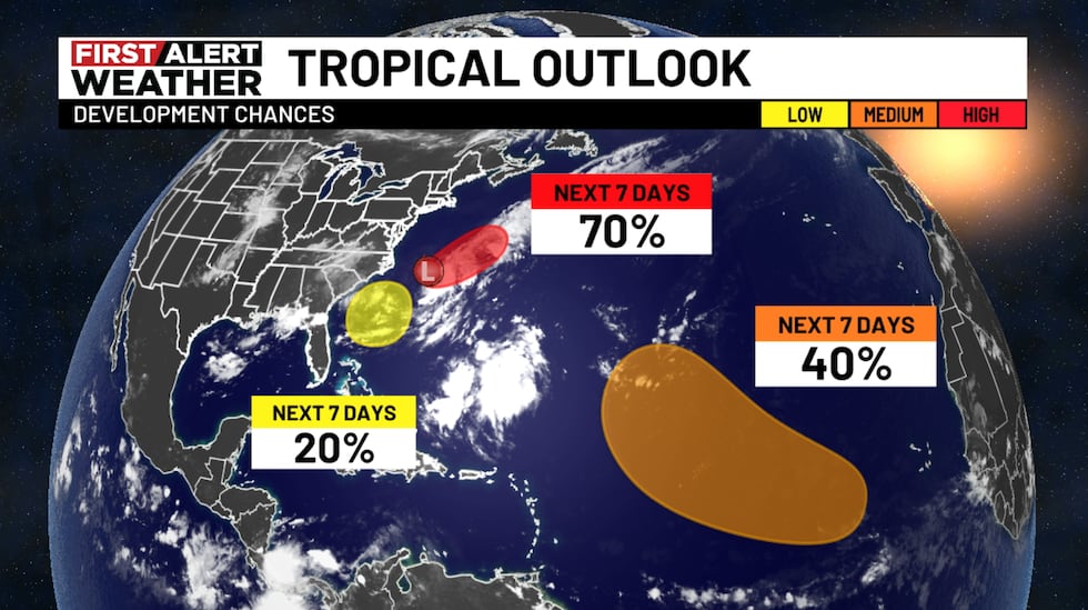 Tropical Outlook(WBRC)
Don’t forget to download the WBRC First Alert Weather app on Android and Apple devices for the latest information!
Get news alerts in the Apple App Store and Google Play Store or subscribe to our email newsletter here.
Copyright 2025 WBRC. All rights reserved.