
Area of low pressure forms off coast of southeastern United States
TRACKING THE TROPICS, RIGHT? THAT’S RIGHT. SO LET’S START OUT WITH THE TROPICS BECAUSE WE JUST GOT THE NEW ADVISORIES IN. AND I MEAN STILL WE HAVE TROPICAL STORM DEXTER. THIS IS NOT A FACTOR. AND IT WILL NOT BECOME ONE AS IT MOVES OUT CLOSER TO EUROPE THAN THE US. BUT INTERESTING TO NOTE, WE’RE STILL TRACKING THIS GLOB OF LOW PRESSURE IN THE DEVELOPMENT PROCESS. I MEAN, IT’S A HUGE EXPANSE HERE OF TROPICAL DOWNPOURS, AND IT HAS A BETTER CHANCE, A MEDIUM CHANCE OF 40% OF DEVELOPING OVER THE SEVEN DAY PERIOD. IT’S GOING TO KIND OF DRIFT A LITTLE WEST CLOSER TO THE WEEKEND. AND THEN OVER THE WEEKEND KIND OF MOVE NORTHEAST AWAY FROM US. BUT STILL IT WILL BE AN EXTRA FACTOR IN THE HEAVY RAINS THAT WE WILL LIKELY SEE SATURDAY AND SUNDAY AFTERNOONS. MEANWHILE, THE SYSTEM THAT HAS AN UP CHANCE OF DEVELOPMENT, PER THE 8 A.M. ADVISORY IS THIS AREA OF LOW PRESSURE THAT IS IN THE DEVELOPMENT PROCESS IN THE TROPICAL ATLANTIC A 60% CHANCE OR A HIGH CHANCE THAT IT ACTUALLY MATERIALIZES INTO AN ENTITY OR A NAMED STORM. AS WE HIT OVER THE NEXT SEVEN DAYS AND IT MOVES ACROSS THESE FAVORABLE CONDITIONS OVER THE OPEN ATLANTIC. RIGHT NOW, THE MODELS ARE KIND OF SPLIT ON WHERE IT GOES. WE’LL CONTINUE TO WATCH IT FOR YOU CAREFULLY. AND AS FAR AS US LOCALLY, IT IS ALL ABOUT THE HEAT HEAT ADVISORY AGAIN FOR THE FIFTH CONSECUTIVE STRAIGHT DAY FOR PALM BEACH COUNTY, 108 TO 112 IS WHAT IT WILL FEEL LIKE WITH THE HUMIDITY OUT THERE ALREADY ON OUR WAY. ACTUAL HIGHS 91 TO 96 DEGREES. YESTERDAY WE HIT 93. 96 IS T
Area of low pressure forms off coast of southeastern United States

Updated: 11:05 AM EDT Aug 6, 2025
WPBF 25 First Warning meteorologists are monitoring a weak area of low pressure that formed several hundred miles off the coast of the southeastern United States.According to the National Hurricane Center, it is currently producing limited shower and thunderstorm activity, and development is likely to be slow to occur during the next few days.There is a 10% chance of development over the next two days and a 40% chance of development over the next seven days.The WPBF 2025 Hurricane Season ForecastPreparing your emergency kit for hurricane seasonHurricane Preparedness Week: Understanding forecast information
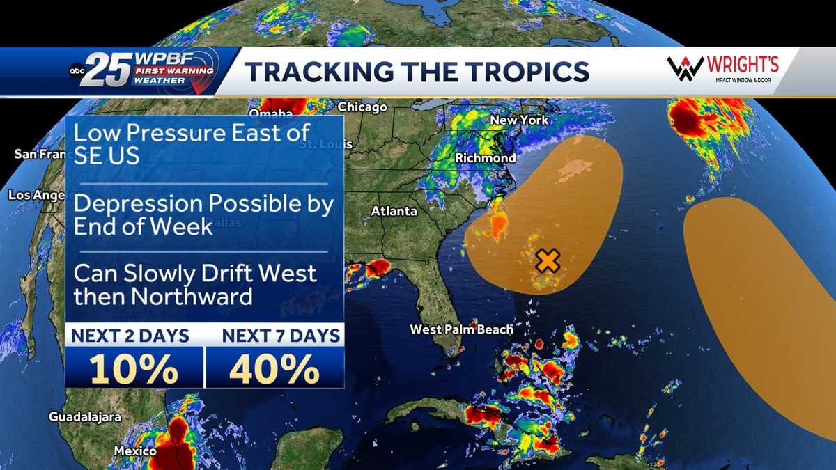
WPBF 25 First Warning meteorologists are monitoring a weak area of low pressure that formed several hundred miles off the coast of the southeastern United States.
According to the National Hurricane Center, it is currently producing limited shower and thunderstorm activity, and development is likely to be slow to occur during the next few days.
There is a 10% chance of development over the next two days and a 40% chance of development over the next seven days.
Preparing your emergency kit for hurricane season
Hurricane Preparedness Week: Understanding forecast information