
Rainy season pattern brings storms and sticky heat to Florida’s Gulf Coast
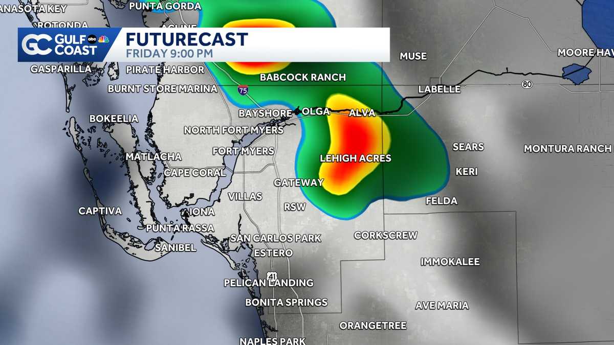
OTHER 2 WERE IN FORT MYERS. AND FOR A SECOND, I THOUGHT WE WOULD HAVE ANOTHER ONE TODAY. YEAH, WE HAD SOME FUNNEL CLOUDS AND IT REACHED THE GROUND. SO WE DID HAVE A PRETTY BIG ACTIVE STORM. IT WAS STRONG. >> IT DIDN’T REACH SEVERE LEVELS. BUT I ALWAYS SAY WHEN IT’S SUMMERTIME HERE WE HAVE THOSE THUNDERSTORMS AND MIGHT NOT TECHNICALLY REACH THE THRESHOLD THAT YOU HAVE TO CHECK OFF TO GET TO SEVERE. >> BUT IT SURE FEELS SEVERE WHEN YOU HAVE YOUR OWN LAWN ORNAMENTS OR WHATEVER KIND OF FLYING DOWN THE ROAD, IT CAN BE SEVERE FOR YOU. SO WE’RE GONNA HAVE MORE OF THAT. NOT ALWAYS THAT STRONG, BUT SOMETIMES THOSE STORMS GET FUNDED. JUST FIND THE PERFECT LITTLE POCKET OF INSTABILITY AND AND REALLY JUST KIND EXPLODED AND REALLY BECOME PRETTY POWERFUL. LET’S HOPE THAT’S NOT THE CASE OF THE WEEKEND. WE’RE STILL KIND OF SEARCHING FOR SOME RAIN. AND THERE’S SOME INDICATIONS THAT IN THE LONG RANGE FORECAST WE MIGHT HAVE SOME AMPLE RAIN HEADED OUR WAY. SO WHAT WE NEED TO KNOW AS WE HEAD THROUGH THE HOLIDAY WEEKEND IS GOING TO RAIN EVERY AFTERNOON. IT’S GOING TO AT YOUR HOUSE EVERY AFTERNOON. PROBABLY NOT. BUT THE CHANCES ARE GOING TO CLOSER TO DESOTO. CHARLOTTE LEE IN THE WESTERN PART OF COLLIER COUNTY INLAND SPOTS AND A CHANCE. BUT IT’S NOT GOING TO BE TIME. BEFORE WE GET TO YOUR HOLIDAY FORECAST. NEW TODAY, THE NATIONAL HURRICANE CENTER RELEASED THEIR FORECAST AND TAKE THIS, YOU KNOW, CAUTIOUSLY BECAUSE, YOU KNOW, THEY ARE EXPECTING A BELOW AVERAGE SEASON THAT DOESN’T REALLY TELL US MUCH. WHERE ARE THOSE STORMS GOING TO HIT? THAT’S WHAT REALLY MATTERS. SO THIS IS GOING TO BE KIND OF TALKING POINT OF USE THESE SEASONAL FORECAST, NOT AS A GUIDE OF HOW TO PREPARE BECAUSE MAYBE THERE WON’T BE AS MANY STORMS. NO, THAT’S NOT WHAT YOU WANT TO DO. USE IT AS A REMINDER TO PREPARE I SAID, HEY, HAVE 5 STORMS OF 30. IT DOESN’T MATTER WHERE THOSE STORMS GOING TO GO. SO THAT’S THE KEY HERE. LA NINA IS HOPEFULLY GOING PLAY A BIG ROLE IN THIS HURRICANE SEASON, BUT IT MIGHT NOT BE FULLY HERE UNTIL A LITTLE BIT LATER ON IN THE HURRICANE SEASON. TOMORROW MORNING, LOW TO MID 70’S. 93 BY THE AFTERNOON. IT’S A REPEAT OF TODAY HUMID CONDITIONS WILL KIND OF WALKING THROUGH THE FRONT FUTURE CAST IN JUST A MOMENT. I HAVE A BRIEF IDEA WHAT TO EXPECT HERE SATURDAY AND SUNDAY. IF YOU’RE OUT AND ABOUT 40% CHANCE OF A SHOWER. SO ENJOY YOUR WEEKEND. BUT KEEP IN MIND, YOU COULD USE OUR APP TO KIND OF DODGE THOSE SHOWERS AND STORMS. THEY’LL BE OUT THERE. SO YOU GOT TO STAY FLEXIBLE. 30% CHANCE ON MONDAY. IN THE LONG RANGE FORECAST. WE’RE NOT EXPECTING ANY TROPICAL DEVELOPMENT. WHAT WE COULD SEE IS A PLUME OF TROPICAL MOISTURE MAYBE HEAD OUR WAY THE FOLLOWING WEEKEND. THAT COULD REALLY HELP WITH SOME OUR DROUGHT SCENARIO. BUT IT’S WAY TOO EARLY TO COME DIVE INTO THOSE DETAILS. LET’S CONCENTRATE ON WHAT’S GOING TO HAPPEN OVER THE NEXT 48 HOURS FOR TOMORROW. THIS IS 4 O’CLOCK ISOLATED SHOWERS BEGIN TO DEVELOP. NOW, THIS LOOKS PRETTY ISOLATED, NOT AS ACTIVE AS IT WAS TODAY. OUR FUTURECAST, THIS WEEK’S BEEN KIND OF UNDER DOING IT A LITTLE BIT. SO KIND OF KEEP THAT IN MIND. 8 O’CLOCK TOMORROW IS STILL LOOKING AT SOME STORMS AND THEY GET ON THE STRONGER SIDE LATER. START AGAIN FOR TOMORROW. SO AROUND DINNER TIME AND JUST THEREAFTER, THEY WILL STILL BE KIND OF AT THEIR PEAK INTENSITY. ONCE WE HEAD INTO SATURDAY. SAME STORY NOW. IT’S SATURDAY. PEOPLE ARE OFF WORK AND JOIN THE MAYBE SOME A GRADUATION PARTIES TOO. WE WILL BE DODGING SOME STORMS. TIME HERE. 7, 30 AT NIGHT AND THEN KIND OF HANGING AROUND SINCE 10, 30. WE STILL HAVE RAIN ON TOP OF CAPE CORAL, FORT MYERS BEACH IN SANTA BOW. WHERE’S THE RAIN GOING TO BE TOMORROW? I MENTIONED MOST OF THE RAIN WILL BE CHARLOTTE, LEE AND WESTERN PART OF COLLIER COUNTY LABELLE. YOU COULD GET A LITTLE A COUPLE PASSING SHOWERS TO ITS NOT RULING OUT RAIN. HERE IS JUST GOING TO BE A LITTLE BIT HIGHER ALONG THE WESTERN PART OF OUR REGION. 40 1% CHANCE OF RAIN RIGHT THROUGH SUNDAY AND THEN INTO EARLY NEXT WEEK. WE BACK OFF A LITTLE BIT, BUT KEEP YOUR EYES ON. MAYBE A PLUME OF TROPICAL MOISTURE THAT CAN REALLY HELP OUR DROUGHT
Rainy season pattern brings storms and sticky heat to Florida’s Gulf Coast

Updated: 11:30 PM EDT May 21, 2026
The sea breeze will be the main weather driver along the Gulf Coast on Friday, as a scattering of downpours and thunderstorms are expected in the afternoon and evening hours. Otherwise, conditions on Friday look warm but seasonable with afternoon highs in the low 90s. This weekend, the weather looks typical for our part of the world late in the month of May. Hot and sunny weather is expected in the morning hours with scattered storms along the sea breeze boundary in the afternoon and evening. However you watch or scroll, we’re committed to delivering your Gulf Coast Weather Most Accurate Forecast, one you can rely on every day, wherever you are.Live Interactive Radar: Track conditions in real time with the Gulf Coast Live Radar.Watch Gulf Coast Weather: Find the latest weather forecast videos, streaming live or on demand, on TV and online.Stream on the Go: Download the free Gulf Coast News app to watch on your phone or tablet.Your Gulf Coast Weather TeamChief Meteorologist Allyson RaeMeteorologist Caroline CastoraMeteorologist Jim DickeyMeteorologist Lauren HopeMeteorologist Raphael TavernierMeteorologist Rob DunsMeteorologist Sara BlueFollow on Social: Follow, like, and subscribe to Gulf Coast News on social media to share your tips and be part of the conversation with Southwest Florida’s most experienced, trusted weather team: Facebook | Instagram | YouTube | TikTok | Threads | Bluesky | Nextdoor | XDOWNLOAD the free Gulf Coast News app for your latest breaking news and weather alerts. And check out the Very Local Gulf Coast app to stream news, entertainment, and original programming on your TV.
FORT MYERS, Fla. —
The sea breeze will be the main weather driver along the Gulf Coast on Friday, as a scattering of downpours and thunderstorms are expected in the afternoon and evening hours.
Otherwise, conditions on Friday look warm but seasonable with afternoon highs in the low 90s.
This weekend, the weather looks typical for our part of the world late in the month of May. Hot and sunny weather is expected in the morning hours with scattered storms along the sea breeze boundary in the afternoon and evening.
However you watch or scroll, we’re committed to delivering your Gulf Coast Weather Most Accurate Forecast, one you can rely on every day, wherever you are.
Live Interactive Radar: Track conditions in real time with the Gulf Coast Live Radar.
Watch Gulf Coast Weather: Find the latest weather forecast videos, streaming live or on demand, on TV and online.
Stream on the Go: Download the free Gulf Coast News app to watch on your phone or tablet.
Your Gulf Coast Weather Team
Follow on Social: Follow, like, and subscribe to Gulf Coast News on social media to share your tips and be part of the conversation with Southwest Florida’s most experienced, trusted weather team: Facebook | Instagram | YouTube | TikTok | Threads | Bluesky | Nextdoor | X
DOWNLOAD the free Gulf Coast News app for your latest breaking news and weather alerts. And check out the Very Local Gulf Coast app to stream news, entertainment, and original programming on your TV.