
Scattered showers and storms for Memorial Day Weekend
THAT’S MAY 29TH AT 9 O’CLOCK ON GULF COAST. NBC. >> AND CAROLINE, THANKS TO YOU IN OR 2 WITH METEOROLOGIST THAT WE CAN PLAN AND PREPARE AS WELL AHEAD OF HURRICANE SEASON. I LOOK FORWARD TO IT. YEAH. WE’VE BEEN WORKING A BUNCH OF DIFFERENT STORIES. I DON’T EVEN KNOW IF WE CAN FIT THEM ALL IN THE HOURS SPECIAL. I KNOW WE HAVE OTHER STUFF COMING UP THIS SUMMER. YOU HEARD THEM SAY THE FORECAST OR OUT CALLING FOR A BELOW AVERAGE SEASON, BUT WE’RE STILL HELPING YOU PREPARE BECAUSE YOU’RE SUPPOSED TO PREPARE FOR HURRICANE SEASON THE SAME WAY EVERY YEAR. NO MATTER WHAT THE FORECAST IS CALLING FOR. REMEMBER, IT ONLY TAKES ONE STORM. WE COULD EVEN SEE LANDFALL ON THE BELOW AVERAGE SEASON. AND THAT’S WHY WE HAVE THAT SPECIAL TO HELP GET YOU READY. BUT THE 2026 HURRICANE SEASON NEXT WEEK DAILY RAIN CHANCES ARE IN THE FORECAST. THAT IS ON OUR RADAR. IT’S BEEN ON OUR RADAR FOR A FEW DAYS. THEY’RE NOT GOING ANYWHERE ANYTIME. SOON AFTERNOON, SHOWERS AND THUNDERSTORMS ARE EXPECTED ACROSS THE GULF COAST EVEN AGAIN TODAY. COVERAGE PEAKS AT ABOUT 40% SATURDAY AFTERNOON. SOMETHING ELSE WE’VE BEEN TRACKING TOASTY TEMPERATURES. THEY’RE NOT GOING ANYWHERE ANYTIME SOON, EITHER. ABOVE AVERAGE TEMPERATURES IN NEAR RECORD HIGHS ARE EVEN POSSIBLE TOMORROW. FORECAST HIGH FOR TODAY IS ABOUT 93 TOMORROW. IT’S 94, WHICH IS ONE DEGREE SHY OF THE RECORD HERE IN FORT MYERS. SOMETHING ELSE THAT WE’RE WATCHING OUT FOR A SURGE OF TROPICAL MOISTURE MID TO LATE NEXT WEEK. THAT COULD BRING MORE WIDESPREAD RAIN. CHANCES ARE JUST HEAVIER RAIN TO PARTS OF THE GULF COAST EARLIER ON IN THE DAY AT TIMES, WE’RE GOING TO REALLY WATCH THIS BECAUSE THAT COULD BRING THE BENEFICIAL RAIN THAT WE NEED AND HELP CLEAR THAT ROUTE OUT ACROSS THE GULF COAST ALSO COULD BRING FLOODING CONCERNS, SOMETHING THAT WE’RE GOING TO BE TRACKING IN JUST A DAY OR SO. NEXT 12 HOURS LOOK LIKE THIS STARTING THINGS OFF. COLE, MUGGY, THOUGH, OUT THERE ACROSS THE GULF COAST, RAIN CHANCES BUILD IN ABOUT 1 2 O’CLOCK STARTING SMALL, 10% COVERAGE. AND THEN BY 4 O’CLOCK, WE PICK IT UP TO 30%. BEST CHANCE TO SEE RAIN ONCE AGAIN WOULD BE LATER ON IN THE AFTERNOON INTO THE EARLY EVENING HOURS. 5, 6, EVEN 7 O’CLOCK COVERAGE WILL BE SCATTERED TODAY. A LOT OF YOU MISSED OUT ON THE RAIN UNLESS YOU LIVE DOWN TOWARDS COLLIER COUNTY OR IF YOU’RE DRIVING ACROSS ALLIGATOR ALLEY YESTERDAY WHERE MULTIPLE INCHES OF RAIN FELL TODAY, WE’RE GOING TO SEE A SIMILAR SETUP WHERE THE RAIN WILL START DOWN TOWARDS COLLIER COUNTY AND THEN WE COULD SEE OTHER DEVELOPMENT ACROSS NORTHERN PARTS OF THE GULF COAST LATER ON IN THE EVENING. THIS IS WHAT THAT LOOKS LIKE. SO THIS BY ABOUT 12 O’CLOCK. SO STARTING SMALL STARTING EARLY SHORT DOWN TOWARDS COLLIER AND THEN WE GET TO ONE 30 LOOK, NOT A LOT OF RAIN IS EXPECTED WITH. THIS IS TRYING TO SHOW YOU. IT’S NOT GOING TO BE A WASHOUT TODAY. SO IF YOU HAVE ANY PLANS, WE HAD SOMETHING GOING ON. IF IT’S ANYWHERE FROM DOING SOME HOUSEWORK, DOING SOME YARD WORK TO GOING TO THE BEACH, TAKING YOUR BOAT OUT, JUST KNOW THAT WE COULD SEE A LITTLE BIT OF RAIN DEPENDING ON WHERE YOU LIVE. I THINK THE LATER WE GO, THE MORE LIKELY IT IS THAT RAIN SHIFTS OFF TO THE NORTH AT 07:30PM, TONIGHT AND THEN 10 O’CLOCK. AND THEN IT SHOULD CLEAR OUT OF HERE AS WE HEAD TOWARDS MIDNIGHT. SO THOSE RAIN CHANCES, LIKE I SAID, THEY’RE NOT GOING ANYWHERE ANYTIME SOON. LOOK AT YOUR SEVEN-DAY FORECAST. DAILY RAIN CHANCES. BUT I WILL SAY AS WE HEAD TOWARDS MIDDLE AND THE END OF NEXT WEEK, WE GOT TO WATCH OUT FOR WEDNESDAY. THURSDAY I WENT AHEAD. I BUMPED WEDNESDAY’S RAIN. CHANCE UP. I THINK THERE WAS ENOUGH DATA TO PROVE THAT A 60% CHANCE OF RAIN WAS WARRANTED BOTH WEDNESDAY AND THURSDAY. AND THAT WILL MAKE THINGS TREND A LITTLE BIT COOLER, RELATIVELY, OF COURSE. AND THEN ALSO INCREASE OUR CLOUD COVER, BRINGING BENEFICIAL RAIN CHANCES. I MEAN, LOOK AT REALLY BUMPS UP MID-WEEK BECAUSE OF THAT TROPICAL MOISTURE SURGE. EXACTLY WHERE IT GOES IS STILL ON THE FENCE FOR WHAT WE’RE EXPECTING. BUT IF IT SHIFTS IN ANY WAY THAT COULD INCREASE RD AND DECREASE OUR RAINFALL TOTALS AND CHANCES MID TO LATE WEEK, SOMETHING TO FOCUS ON, ESPECIALLY IF YOU HAVE ANY BIG PLANS HEADING TOWARDS NEXT WEEKEND AS WELL. HERE’S JUST A LOOK AT WHAT THE RAIN COULD LOOK LIKE OVER THE NEXT WEEK. SO WE SEE THOSE TOTALS JUST GRADUALLY INCREASE EACH AND EVERY DAY. BUT THE FACT THAT WE’RE SEEING WIDESPREAD SWATH OF OVER AN INCH OF RAIN ALMOST EVERYWHERE THAT’S ENCOURAGING TO SEE CONSIDERING THE DROUGHT CONDITIONS THAT ARE ONGOING. I’LL TAL
Memorial Day Weekend is here and it looks to be hot and humid with daily rain chances in the afternoon and evening hours. Your Gulf Coast Weather Most Accurate Forecast calls for high temperatures to reach the low 90s, and on Sunday we will be one degree shy of tying a record high temperature in Fort Myers. This afternoon, showers and thunderstorms will develop first down towards Collier County before development shifts northward as we move into the evening hours. Coverage peaks at 40% today.Sunday and Monday trend slightly drier, with rain chances at 30% for those days. It’ll still be hot, though, with highs in the 90s before a pattern shift midweek.A surge in tropical moisture late next week is on our radar, and it is something we will continue to monitor in the coming days.However you watch or scroll, we’re committed to delivering your Gulf Coast Weather Most Accurate Forecast, one you can rely on every day, wherever you are.Live Interactive Radar: Track conditions in real time with the Gulf Coast Live Radar.Watch Gulf Coast Weather: Find the latest weather forecast videos, streaming live or on demand, on TV and online.Stream on the Go: Download the free Gulf Coast News app to watch on your phone or tablet.Your Gulf Coast Weather TeamChief Meteorologist Allyson RaeMeteorologist Caroline CastoraMeteorologist Jim DickeyMeteorologist Lauren HopeMeteorologist Raphael TavernierMeteorologist Rob DunsMeteorologist Sara BlueFollow on Social: Follow, like, and subscribe to Gulf Coast News on social media to share your tips and be part of the conversation with Southwest Florida’s most experienced, trusted weather team: Facebook | Instagram | YouTube | TikTok | Threads | Bluesky | Nextdoor | XDOWNLOAD the free Gulf Coast News app for your latest breaking news and weather alerts. And check out the Very Local Gulf Coast app to stream news, entertainment, and original programming on your TV.
FORT MYERS, Fla. —
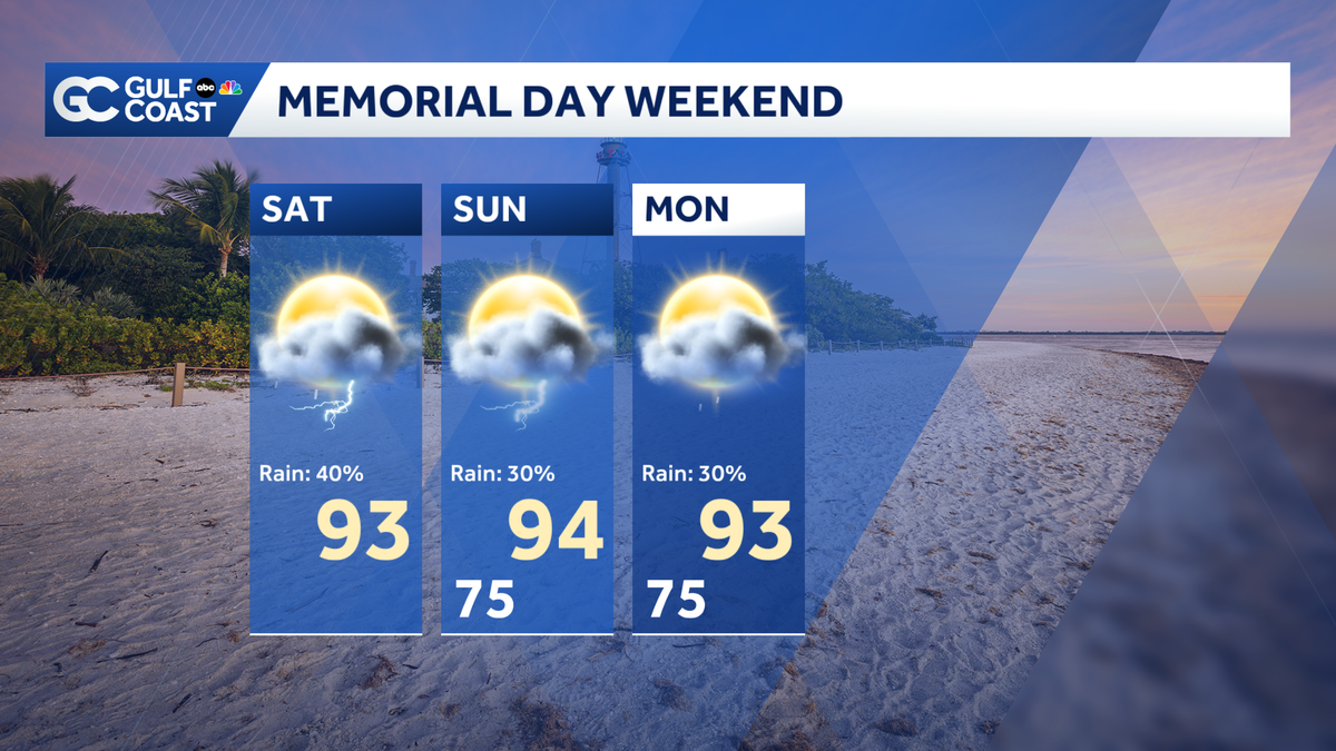
Memorial Day Weekend is here and it looks to be hot and humid with daily rain chances in the afternoon and evening hours. Your Gulf Coast Weather Most Accurate Forecast calls for high temperatures to reach the low 90s, and on Sunday we will be one degree shy of tying a record high temperature in Fort Myers.
This afternoon, showers and thunderstorms will develop first down towards Collier County before development shifts northward as we move into the evening hours. Coverage peaks at 40% today.
Sunday and Monday trend slightly drier, with rain chances at 30% for those days. It’ll still be hot, though, with highs in the 90s before a pattern shift midweek.
A surge in tropical moisture late next week is on our radar, and it is something we will continue to monitor in the coming days.
However you watch or scroll, we’re committed to delivering your Gulf Coast Weather Most Accurate Forecast, one you can rely on every day, wherever you are.
Live Interactive Radar: Track conditions in real time with the Gulf Coast Live Radar.
Watch Gulf Coast Weather: Find the latest weather forecast videos, streaming live or on demand, on TV and online.
Stream on the Go: Download the free Gulf Coast News app to watch on your phone or tablet.
Your Gulf Coast Weather Team
Follow on Social: Follow, like, and subscribe to Gulf Coast News on social media to share your tips and be part of the conversation with Southwest Florida’s most experienced, trusted weather team: Facebook | Instagram | YouTube | TikTok | Threads | Bluesky | Nextdoor | X
DOWNLOAD the free Gulf Coast News app for your latest breaking news and weather alerts. And check out the Very Local Gulf Coast app to stream news, entertainment, and original programming on your TV.