
>> FREE ADMISSION STARTED YESTERDAY AND IT RUNS THROUGH MONDAY. WELL, BUY YOU, SIR. I WOULD NOT WANT TO GO TO THE PARKS WITH ALL THE STORMS HAPPENING RIGHT THE WAIT UNTIL TOMORROW MORNING. WE HAVE A CHANCE TO DRY OUT. STILL SOME SHOWERS AND SOME RUMBLES OF THUNDER THAT ARE MAKING THEIR WAY ACROSS THE GULF COAST RIGHT NOW. >> THE GOOD NEWS IS THAT BEAST RAIN IS STARTING TO SHIFT AWAY FROM THE LAND AND INTO THE GULF. RIGHT NOW. THERE ONE LINGERING THUNDERSTORM THAT’S NEAR BOKEELIA. THIS IS MAKING ITS WAY OFF TO THE WEST. STILL A COUPLE OF HEAVY POCKETS OF RAIN NEAR THE BARRIER ISLANDS. BUT THE WORST OF IT NOW MOVING OFF TO THE WEST. WE DO HAVE A FLOOD ADVISORY THAT’S STILL ACTIVE IN LEE COUNTY. THAT’S GOING TO LINGER ALL THE WAY THROUGH 7.15, TODAY FOR THE AREAS HIGHLIGHTED IN GREEN. THE HEAVIEST RAINFALL HAS MOVED OFF, BUT WE’VE ALREADY SEEN ABOUT 3 INCHES OF RAIN FALL IN THIS AREA. SO IT DOESN’T TAKE MUCH FOR STANDING WATER TO FORM. REMEMBER, TO NEVER DRIVE INTO FLOODED ROADWAYS RIGHT NOW. JUST A BIT OF LIGHT RAIN AND SOUTH EASTERN LEE COUNTY. THAT’S NEAR SAN CARLOS PARK STRETCHING BACK OFF TO THE COUNTY LINE. THIS IS ALL FORMING DUE TO THE SEABREEZE. IT’S STARTING TO SHIFT BACK UP TO THE GULF. SO WE’LL LIKELY SEE THE HEAVIEST RAIN CONTINUE TO IMPACT OUR COASTAL COMMUNITIES AND OFF INTO THE GULF OVER THE NEXT SEVERAL HOURS. THAT’S AS THE SEABREEZE RETREATS OFF TO THE WEST. WE WALK YOU THROUGH FUTURECAST ON AND OFF. SHOWERS ARE STILL POSSIBLE. THAT’S GOING TO BE UNTIL AROUND 7, MAYBE 08:00PM. TONIGHT WE BEGIN TO LOSE STEAM AFTER THE SUN SETS. IT’S MOSTLY DRY THROUGH THE OVERNIGHT HOURS BUT DON’T PUT HER UMBRELLA AWAY JUST YET BECAUSE WE HAVE ANOTHER ROUND OF RAIN ON THE WAY TOMORROW. WE BROKE THIS EARLIER AT OUR 6 O’CLOCK NEWSCAST. THERE ARE 3 FIRES THAT WE’VE BEEN REPORTED IN CHARLOTTE COUNTY. WE STILL ARE TRACKING THAT FIRE RISK TODAY. A LOT OF THAT JUST DUE TO THE LINGERING RISK OF THUNDERSTORMS. WANT TO TAKE YOU OUT TO THE CELL THAT LIKELY CAUSED THESE BRUSH FIRES. WE WERE SAYING AROUND 250 LIGHTNING STRIKES AROUND THE TIME THAT THESE WERE REPORTED, LOT OF THOSE WERE NEGATIVE STRIKES. BUT WE DID SEE A COUPLE OF POSITIVE LIGHTNING STRIKES. THOSE ONES ARE STRONGER AND HOTTER THAT REALLY HELPS TO ELEVATE THAT RISK OF BRUSH FIRES. THAT STORM NOW HAS DIED DOWN AND MOVED OFF TO THE WEST. ANOTHER ROUND OF STORMS ON THE WAY FOR YOUR MEMORIAL DAY. THAT’S COMING IN IN THE AFTERNOON. SO IF YOU’RE PLANNING TO GET OUTDOORS TO HONOR MEMORIAL DAY, GO BEFORE LUNCH. AS WE GET INTO THE AFTERNOON, WE’LL START TO THE SEE THE SHOWERS AND THUNDERSTORMS FORM AGAIN. A LOT OF THIS GOING TO IMPACT I-75 CORRIDOR. I THINK THAT WILL WAIT UNTIL AFTER LUNCH TO SEE THAT A FEW ISOLATED DOWNPOURS, NOT AS MUCH IN COLLIER COUNTY, BUT A BETTER CHANCE LEE CHARLOTTE AND DESOTO COUNTIES TOMORROW AFTERNOON, WE DRY OUT AFTER SUNSET. NOT EVERYONE IS GOING TO SEE RAIN TOMORROW NOT EVERYONE SAW RAIN THIS AFTERNOON TAKING A LIVE OUTSIDE AT THE AT US AND BROUGHT A BRIDGE. YOU CAN SEE JUST SOME PASSING CLOUDS OUT THERE. TEMPERATURES CURRENTLY SITTING IN THE UPPER 70’S WILL BE A VERY, VERY SLOW COOLDOWN OVERNIGHT. WELL, ONLY MAKE IT TO THE LOW TO MID 70’S BY EARLY TOMORROW MORNING. 75 WAKING UP TOMORROW. BUT THE HEAT IS BACK ON FOR MEMORIAL DAY UP TO 93 IN FORT MYERS. AND 94, IF YOU’RE IN CAPE CORAL, RAIN, CHANCES STILL LINGER IN THE AFTERNOON WILL BE A RINSE AND REPEAT OF THAT TUESDAY, TEMPERATURES STILL HOVERING IN THE LOW TO MID 90’S. WE’LL START TO SEE A SURGE OF HUMIDITY, A SURGE OF TROPICAL MOISTURE AT THE END OF OUR 7 DAY FORECAST. THAT’S WHEN WE HAVE ALL OF GLOOMY WEATHER STANDING BETWEEN US AND SATURDAY AND SUNDAY ABOUT A 60% CHANCE OF RAIN WEDNESDAY, ALL THE WAY THROUGH FRIDAY FRIDAY. THEY PREPARED FOR THOSE WIDESPREAD SHOWERS AND THUNDERSTORMS? I THINK BIGGEST TAKEAWAY OVER THE NEXT 7 DAYS IS THAT THERE WILL BE AFTERNOON SHOWERS AND THUNDERSTORMS EVERY DAY THIS WEEK, SOME AREAS COULD GET SOME HEAVY DOWNPOURS ON THE ORDER OF MULTIPLE INCHES. SO
Minor flood risk Sunday evening; Rain chances spike later this week
Afternoon showers will pop up every day out of the next seven.

Updated: 6:54 PM EDT May 24, 2026
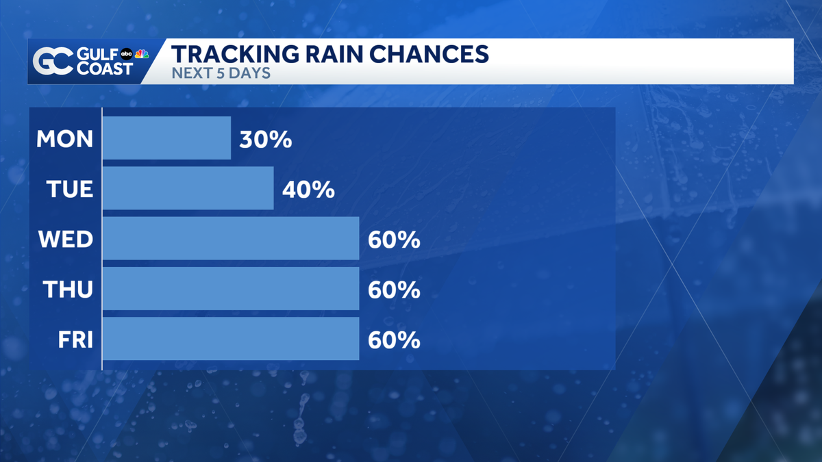
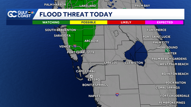
Soggy weather is here to stay on the Gulf Coast. Your Gulf Coast Weather Most Accurate Forecast calls for scattered showers and thunderstorms Sunday evening. Most of the rain will target the Interstate 75 corridor. Buckets of rain will fall on some communities, but not everyone will see rain. There is a minor flood risk Sunday evening for parts of Charlotte and DeSoto counties. More afternoon showers and thunderstorms are possible again on Memorial Day, but our rain chances will peak at only 30%. Monday will be one of the drier days of the week. Big changes are on the way midweek as rain chances spike. Wednesday through Friday will feature plenty of storms, as rain chances peak at 60%. The humidity and the clouds will ease some of the warmth. Expect highs in the upper 80s late this week. However you watch or scroll, we’re committed to delivering your Gulf Coast Weather Most Accurate Forecast, one you can rely on every day, wherever you are.Live Interactive Radar: Track conditions in real time with the Gulf Coast Live Radar.Watch Gulf Coast Weather: Find the latest weather forecast videos, streaming live or on demand, on TV and online.Stream on the Go: Download the free Gulf Coast News app to watch on your phone or tablet.Your Gulf Coast Weather TeamChief Meteorologist Allyson RaeMeteorologist Caroline CastoraMeteorologist Jim DickeyMeteorologist Lauren HopeMeteorologist Raphael TavernierMeteorologist Rob DunsMeteorologist Sara BlueFollow on Social: Follow, like, and subscribe to Gulf Coast News on social media to share your tips and be part of the conversation with Southwest Florida’s most experienced, trusted weather team: Facebook | Instagram | YouTube | TikTok | Threads | Bluesky | Nextdoor | XDOWNLOAD the free Gulf Coast News app for your latest breaking news and weather alerts. And check out the Very Local Gulf Coast app to stream news, entertainment, and original programming on your TV.
Soggy weather is here to stay on the Gulf Coast.
Your Gulf Coast Weather Most Accurate Forecast calls for scattered showers and thunderstorms Sunday evening. Most of the rain will target the Interstate 75 corridor. Buckets of rain will fall on some communities, but not everyone will see rain. There is a minor flood risk Sunday evening for parts of Charlotte and DeSoto counties.
More afternoon showers and thunderstorms are possible again on Memorial Day, but our rain chances will peak at only 30%. Monday will be one of the drier days of the week.
Big changes are on the way midweek as rain chances spike. Wednesday through Friday will feature plenty of storms, as rain chances peak at 60%. The humidity and the clouds will ease some of the warmth. Expect highs in the upper 80s late this week.
However you watch or scroll, we’re committed to delivering your Gulf Coast Weather Most Accurate Forecast, one you can rely on every day, wherever you are.
Live Interactive Radar: Track conditions in real time with the Gulf Coast Live Radar.
Watch Gulf Coast Weather: Find the latest weather forecast videos, streaming live or on demand, on TV and online.
Stream on the Go: Download the free Gulf Coast News app to watch on your phone or tablet.
Your Gulf Coast Weather Team
Follow on Social: Follow, like, and subscribe to Gulf Coast News on social media to share your tips and be part of the conversation with Southwest Florida’s most experienced, trusted weather team: Facebook | Instagram | YouTube | TikTok | Threads | Bluesky | Nextdoor | X
DOWNLOAD the free Gulf Coast News app for your latest breaking news and weather alerts. And check out the Very Local Gulf Coast app to stream news, entertainment, and original programming on your TV.