
ROAD. WRITTEN FOR LOT OF CARS. ALL RIGHT. AND WE HAVE A LOT OF RAIN FOR TOMORROW. A LOT OF IT IS GOING TO BE MAINLY INLAND. BUT OUR COASTAL SPOTS COULD SEE THAT RAIN PUSHED THROUGH LITTLE BIT EARLIER IN THE DAY. SO HERE’S THE JUST WE’RE GOING TO SEE RAIN ALMOST EACH AFTERNOON. BUT TOMORROW, MAYBE EARLY AFTERNOON OR EVEN LATE MORNING FOR THE COASTAL SPONSOR. MUCH OF THE RAIN TOMORROW WILL BE INLAND. WE’LL SHOW YOU IN JUST A MOMENT. OUR BEST RAIN CHANCES ARE GOING TO BE TOMORROW AND THEN THE KIND OF TAPER BACK OFF. WHEN WE LOOK AT GULF COAST LIVE RADAR, WE CAN SEE ALL OF THESE STORMS PUSHING AWAY FROM OUR COASTLINES OFF TO THE NORTH AND WEST. HOWEVER, TOMORROW WINDS WILL TURN PUSH ALL THOSE SHOWERS INLAND AND ON SHORE BRIEFLY FOR COASTAL SPOTS BEFORE HEADING ON INLAND. SO LITTLE BIT OF A DIFFERENT PATTERN FOR TOMORROW, BUT THE RESULT ENDS UP BEING THE SAME. WE GET AFTERNOON RAIN. WE DO HAVE ABOUT ONE TO 2 INCHES OF RAIN POSSIBLE FOR SOME LUCKY FOLKS WILL HAVE THAT MAINLY ALONG AND EAST OF 75 NOTICE. YOU LOOK CLOSER TO THE COASTLINES, CAPE CORAL, BONITA AND NAPLES. IT SHOWING 0. I WANT TO BE SO FAR TO SAY WE’RE NOT GONNA GET ANY RAIN SPECIFICALLY AROUND PLACES LIKE CAPE CORAL, FORT MYERS. BUT THE CHANCES ARE GOING TO BE A LITTLE BIT HIGHER FOR THOSE AREAS INLAND SHOW THAT ON YOUR FUTURE CAST IN JUST A MOMENT TO OUR MORNING, IT’S MILD INTO THE 70’S, BUT BECAUSE WE’LL HAVE EXTRA CLOUD COVER AND RAIN A LITTLE BIT EARLIER THAN WHAT WE TYPICALLY SEE. TEMPERATURES ARE GOING TO HARD TIME GETTING TO THE 90’S. RAIN COULD START AS EARLY AS LUNCHTIME. SO WE DON’T HAVE THAT 12 TO 3 WINDOW TO SEE A LOT OF SUNSHINE AND GET THOSE STORMS GOING AND GET INTO THE 90’S. SO BY THE AFTERNOON ON FRIDAY, WE’LL KIND OF WAIT TO THAT MORE 3, 4 O’CLOCK TIME FRAME HAVE A CHANCE TO GET INTO THE 90’S SATURDAY AND SUNDAY, SAME DEAL AND THEN INTO NEXT WEEK BUT COULD RUN WITH THOSE ONSHORE WINDS HAVE UPPER 80’S RETURN TO THE FORECAST. LET ME WALK YOU THROUGH WHAT TO EXPECT TOMORROW. AGAIN, A LOT OF THOSE SHOWERS ARE GOING TO STAY OFFSHORE UNTIL ABOUT MID TO LATE MORNING. HOWEVER, BE ADVISED THAT ONSHORE WINDS CAN EASILY PRODUCE COASTAL SHOWERS MUCH EARLIER THAN A LOT OF THE MODELS HAVE A GOOD JOB HANDLING. SO BETWEEN SUMMARIZE AND REALLY ANY TIME MID MORNING, THERE COULD BE SOME COASTAL SHOWERS. FUTURECAST IS GOING TO HARD TIME DETERMINING THAT WITH THE CURRENT SETUP. SO KEEP THAT IN MIND. HOWEVER, THE MAIN TREND FOR TOMORROW WILL BE AFTER THAT 12 O’CLOCK TIME FRAME. THAT’S GOING TO BE THE CHANCE THAT AREAS CLOSER TO THE COASTLINE HAVE A BETTER CHANCE OF DOWNPOURS. SO THIS IS JUST AFTER 1 O’CLOCK. WE HAVE DOWNPOURS PUSHING THROUGH GATEWAY IN LEHIGH, NORTH FORT MYERS, AND THEN THE BULK OF THE HEAVIER RAIN STARTS TO DEVELOP INLAND BY 3 O’CLOCK. THEN WE GET A LITTLE BIT OF A BREAK IN THE ACTION. NOTICE THE OTHER SIDE OF THE STATE. THAT’S WHERE WE COULD SEE EXCESSIVE RAIN AND SOME STRONGER STORMS. NOT SO MUCH FOR US. HOWEVER, ONCE WE HEAD INTO DINNER TIME WE GET A RESURGENCE OF SOME MORE STORMS AROUND THE REGION. AND THIS IS WHERE WE COULD PICK UP AN INCH AN INCH AND A HALF OF RAIN FOR INLAND SPOTS. HENRY COUNTY INLAND COLLIER, EVEN EASTERN LEE AND EASTERN CHARLOTTE COUNTY. THIS WILL STICK AROUND TO ABOUT 9 OR 10 O’CLOCK. WE ARE NOT EXPECTING SEVERE WEATHER ON THIS SIDE OF THE STATE. WE ARE EXPECTING SOME RAIN AND GUSTY WINDS ASSOCIATED WITH IT BY THE TIME THE NEXT COUPLE OF DAYS ARE DONE BECAUSE MOST OF THE MOST AMOUNT OF RAIN AND THEN JUST KIND OF AVERAGE RAIN FOR THE NEXT UP FRIDAY, SATURDAY, SUNDAY, RAINFALL TOTALS ANYWHERE FROM ONE TO 2 INCHES OF RAIN. 70% CHANCE OF RAIN FOR TOMORROW
Scattered storms Thursday
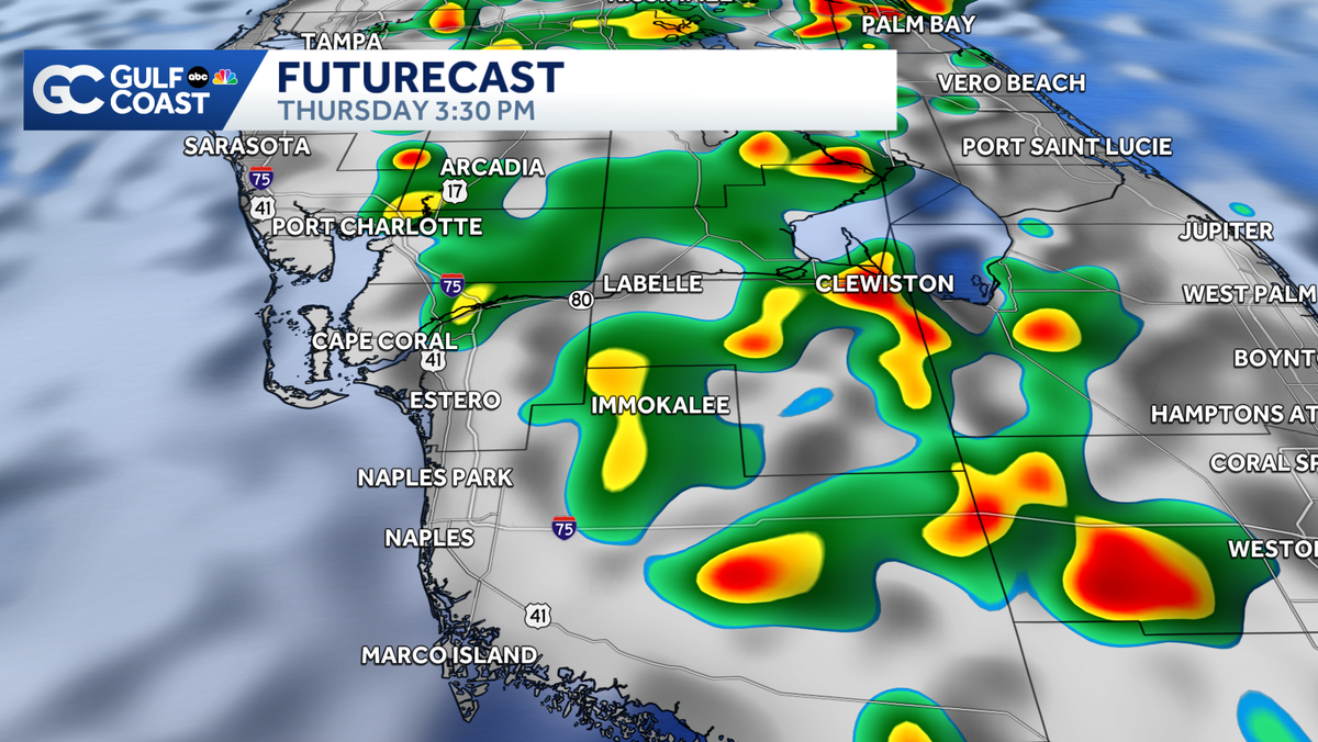
Rain chances increase through the end of the work week as more moisture works into Southwest Florida.

Updated: 11:30 PM EDT May 27, 2026
Your Gulf Coast Weather Most Accurate Forecast says a plume of tropical moisture will ooze into the region on Thursday, prompting elevated rain chances. A shift to an onshore wind can bring rain earlier in the day along the coast before most of the rain pushes inland to Hendry and Glades counties. The main threats will be heavy rain, lightning and minor flooding. Looking ahead to the weekend, expect hot conditions in the low 90s with scattered afternoon storms. No one day will be a washout over the next week, but many neighborhoods will come away with multiple inches of rain. Hurricane season returns June 1, though the tropics remain quiet with no development expected over the next seven days. However you watch or scroll, we’re committed to delivering your Gulf Coast Weather Most Accurate Forecast, one you can rely on every day, wherever you are.Live Interactive Radar: Track conditions in real time with the Gulf Coast Live Radar.Watch Gulf Coast Weather: Find the latest weather forecast videos, streaming live or on demand, on TV and online.Stream on the Go: Download the free Gulf Coast News app to watch on your phone or tablet.Your Gulf Coast Weather TeamChief Meteorologist Allyson RaeMeteorologist Caroline CastoraMeteorologist Jim DickeyMeteorologist Lauren HopeMeteorologist Raphael TavernierMeteorologist Rob DunsMeteorologist Sara BlueFollow on Social: Follow, like and subscribe to Gulf Coast News on social media to share your tips and be part of the conversation with Southwest Florida’s most experienced, trusted weather team: Facebook | Instagram | YouTube | TikTok | Threads | Bluesky | Nextdoor | XDOWNLOAD the free Gulf Coast News app for your latest breaking news and weather alerts. And check out the Very Local Gulf Coast app to stream news, entertainment, and original programming on your TV.
FORT MYERS, Fla. —
Your Gulf Coast Weather Most Accurate Forecast says a plume of tropical moisture will ooze into the region on Thursday, prompting elevated rain chances.
A shift to an onshore wind can bring rain earlier in the day along the coast before most of the rain pushes inland to Hendry and Glades counties. The main threats will be heavy rain, lightning and minor flooding.
Looking ahead to the weekend, expect hot conditions in the low 90s with scattered afternoon storms. No one day will be a washout over the next week, but many neighborhoods will come away with multiple inches of rain.

Hurricane season returns June 1, though the tropics remain quiet with no development expected over the next seven days.
However you watch or scroll, we’re committed to delivering your Gulf Coast Weather Most Accurate Forecast, one you can rely on every day, wherever you are.
Live Interactive Radar: Track conditions in real time with the Gulf Coast Live Radar.
Watch Gulf Coast Weather: Find the latest weather forecast videos, streaming live or on demand, on TV and online.
Stream on the Go: Download the free Gulf Coast News app to watch on your phone or tablet.
Your Gulf Coast Weather Team
Follow on Social: Follow, like and subscribe to Gulf Coast News on social media to share your tips and be part of the conversation with Southwest Florida’s most experienced, trusted weather team: Facebook | Instagram | YouTube | TikTok | Threads | Bluesky | Nextdoor | X
DOWNLOAD the free Gulf Coast News app for your latest breaking news and weather alerts. And check out the Very Local Gulf Coast app to stream news, entertainment, and original programming on your TV.