
Inland rain possible Sunday afternoon
SAID NO ROCKET DEBRIS HERE IN THE GULF. THAT’S ALWAYS A PLUS FOR US. AND I HONESTLY THINK TODAY WOULD BE ANOTHER GREAT BEACH DAY FOR US. THE REASON THE PLACEMENT OF THE RAIN CHANCES THAT WE HAVE ACROSS THE GULF COAST, THIS SUNDAY ONSHORE WINDS. IT’S SOMETHING WE’VE BEEN TALKING ABOUT LATELY. IT’S WHAT CAUSED THE RAIN THAT WE SAW ON SATURDAY MORNING. >> WE KEEP THAT IN PLACE AS THEY MOVE INTO THIS NEXT WEEK. THAT MEANS WE COULD SEE SOME SPRINKLES EARLIER ON IN THE DAY MONDAY AND TUESDAY COMPARED TO WHAT WE’RE USED TO. BUT BY THE AFTERNOON, THOSE STORMS THAT DO DEVELOP, THEY MOVE INLAND. AND SO THAT’LL BE THE NEXT THING THAT WILL BE TRACKING. IT WAS SOGGY YESTERDAY AT TIMES, ESPECIALLY EARLIER ON. IT WAS ALSO VERY, VERY MUGGY BECAUSE THE MOISTURE CONTENT WE HAVE IN THE YEAR THE PAST. 24 HOURS, ALMOST EVERYBODY SAW SOME SORT OF RAIN WEATHER IF IT WAS JUST TRACE OR EVEN MORE, ESPECIALLY FOR INLAND LOCATIONS. THE RADAR LOOKS EMPTY THIS SUNDAY MORNING. NOT REALLY EXPECTING RAIN TO DEVELOP UNTIL WE HAD INTO THE LATER AFTERNOON HOURS AND WILL BE THAT SETUP WHERE WE SEE THE STORMS FORM GENERALLY EAST OF THE I-75 CORRIDOR AND THEN MAKE THEIR WAY TO THE OTHER SIDE OF THE STATE. HERE’S WHAT THAT LOOKS LIKE BY 1 O’CLOCK. LOOK, LITTLE CELL POSSIBLY DEVELOPING DOWN TOWARDS COLLIER COUNTY AND THEN IT FAVORS OUR INLAND COUNTIES LIKE HENDRY AND GLADES. THAT’S WHAT IT LOOKS LIKE BY ABOUT 2.30 AND THEN LOOK OUT TOWARDS CLEWISTON KIND OF IN THE HOT SPOT FOR RAIN LATELY. JUST GIVEN THE PATTERN THAT WE’RE IN 4 O’CLOCK THIS AFTERNOON, WE STILL HAVE THAT RAIN FAVORING THE EASTERN FRENCH IS THE GULF COAST AND HONESTLY THE OTHER SIDE OF THE STATE AS WELL. THEY COULD SEE MORE COVERAGE AS YOU HEAD TOWARDS THE FORT LAUDERDALE, MIAMI AREA AND EVEN UP TOWARDS WEST PALM TO THEY COULD SEE BETTER RAIN CHANCES. NOT NECESSARILY FOR US HERE. I MEAN, LOOK, THE COAST DAYS, MOSTLY IF NOT COMPLETELY DRY FOR YOUR SUNDAY. THAT’S WHY THE A GOOD BEACH DAY RIGHT? AND TRY AND CLEAR THAT RAIN OUT OF HERE. LOOK OVER THE GULF, THOUGH. THIS IS MIDNIGHT. YOU START TO SEE SOME OF THAT ON SHORE FLOW, MEANING WE COULD SEE SOME OF THAT RAIN A LITTLE BIT EARLIER ON THE TALK ABOUT THAT MORE COMING UP HERE. JUST SECOND. THEY DO IS SHOW YOUR 7 DAY JUST SO YOU CAN GET READY FOR THE WORK WEEK AS WELL. TODAY’S THE LAST DAY OF MAY, WHICH MEANS METEOROLOGICAL SUMMER STARTS OFF TOMORROW. ALSO MEANS HURRICANE SEASON STARTS OFF TOMORROW ON JUNE. 1ST. NOW THAT REALLY WON’T MAKE AN IMPACT ON OUR FORECAST. THERE’S NOTHING THAT WE’RE TRACKING TROPICAL OUT THERE CURRENTLY, BUT WE ARE KEEPING AN EYE ON A HIGHER RAIN CHANCE BY THE MIDDLE PART OF THE WORKWEEK. I BUMPED BACK COVERAGE UP TO 60% FOR WEDNESDAY. IT WILL DROP OUR TEMPERATURE DOWN JUST A COUPLE OF DEGREES. 42 DRY OUT AT THE END OF THE FORECAST PERIOD. LOOK AT FRIDAY AND SATURDAY, SOME OF THE DRIEST DAYS WE’VE SEEN LATELY HERE ACROSS THE GULF COAST, THOSE RAIN CHANCES, LIKE I SAID, PEAK DURING AFTERNOON HOURS ON WEDNESDAY. BUT BECAUSE THAT ONSHORE FLOW, WE COULD SEE SOME OF THAT RAIN EARLIER ON AS WE MOVE INTO YOUR MONDAY MORNING. AND THIS IS WHAT IT COULD LOOK LIKE. SO WATCH. THIS IS BY 10 O’CLOCK THAT SLIGHT LIKE GREEN THAT WOULD CORRELATE TO SOME SPRINKLE SIMILAR TO WHAT WE SAW YESTERDAY WAS KIND OF JUST SPINNING OUTSIDE FOR A COUPLE OF HOURS. IT WILL ALSO BE MUGGY, TOO, THAT MORNING RAIN COULD CONTRIBUTE SLOW, POTENTIALLY THE LESS COVERAGE IN THE AFTERNOON. THIS IS MONDAY AT 6 O’CLOCK. IT DOESN’T REALLY SHOW MUCH RAIN ACROSS THE GULF COAST. I DO THINK, THOUGH, HAVE A LITTLE BIT MORE THAN WHAT THIS MODEL SHOWING JUST FOR US TO DO IT ALL OVER AGAIN ON TUESDAY MORNING. YOU SEE SOME OF THAT ON SHORE FLOW, BRINGING SOME SPRINKLES TO THE GULF COAST AS WE HEAD THROUGH THE EARLIER HOURS FOR THE FIRST 2 DAYS OF THIS WEEK, AMOUNTING TO NOT A LOT OF RAINFALL. THIS ISN’T A SETUP THAT’S REALLY GOING TO SATURATE THINGS ACROSS THE GULF COAST, BUT IT’S GOING BRING SOME DAILY RAIN CHANCES TO THE AREA, BUT JUST SOMETHING THAT WE STILL NEED AS WE CHIP AWAY AT T
The last day of meteorological spring is going to end in an average way across the Gulf Coast with a high temperature in the upper 80s or low 90s and a small rain chance. Your Gulf Coast Weather Most Accurate Forecast has inland rain this afternoon, favoring Collier, Hendry, and Glades counties. Coverage peaks at only 30%.Some spots on Monday and Tuesday morning could see some sprinkles thanks to onshore flow, but the majority of the rain will hold off until the afternoon hours.This month was a hot one, and for Fort Myers it was the second hottest May on record with an average temperature of 82.2. In Naples, this May was the wettest on record, where 6.95″ of rainfall was observed at the airport. For comparison, on average, Naples usually observes 2.26″ of rain during the month of May.The 2026 hurricane season begins tomorrow, and no tropical activity is expected over the next seven days.Live Interactive Radar: Track conditions in real time with the Gulf Coast Live Radar.Watch Gulf Coast Weather: Find the latest weather forecast videos, streaming live or on demand, on TV and online.Stream on the Go: Download the free Gulf Coast News app to watch on your phone or tablet.Your Gulf Coast Weather TeamChief Meteorologist Allyson RaeMeteorologist Caroline CastoraMeteorologist Jim DickeyMeteorologist Lauren HopeMeteorologist Raphael TavernierMeteorologist Rob DunsMeteorologist Sara BlueFollow on Social: Follow, like, and subscribe to Gulf Coast News on social media to share your tips and be part of the conversation with Southwest Florida’s most experienced, trusted weather team: Facebook | Instagram | YouTube | TikTok | Threads | Bluesky | Nextdoor | XDOWNLOAD the free Gulf Coast News app for your latest breaking news and weather alerts. And check out the Very Local Gulf Coast app to stream news, entertainment and original programming on your TV.
FORT MYERS, Fla. —
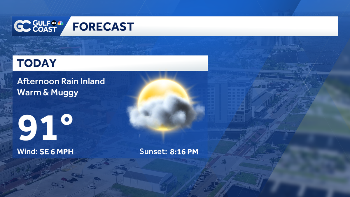
The last day of meteorological spring is going to end in an average way across the Gulf Coast with a high temperature in the upper 80s or low 90s and a small rain chance.
Your Gulf Coast Weather Most Accurate Forecast has inland rain this afternoon, favoring Collier, Hendry, and Glades counties. Coverage peaks at only 30%.
Some spots on Monday and Tuesday morning could see some sprinkles thanks to onshore flow, but the majority of the rain will hold off until the afternoon hours.
This month was a hot one, and for Fort Myers it was the second hottest May on record with an average temperature of 82.2.
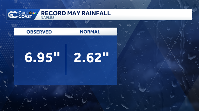
In Naples, this May was the wettest on record, where 6.95″ of rainfall was observed at the airport. For comparison, on average, Naples usually observes 2.26″ of rain during the month of May.
The 2026 hurricane season begins tomorrow, and no tropical activity is expected over the next seven days.
Live Interactive Radar: Track conditions in real time with the Gulf Coast Live Radar.
Watch Gulf Coast Weather: Find the latest weather forecast videos, streaming live or on demand, on TV and online.
Stream on the Go: Download the free Gulf Coast News app to watch on your phone or tablet.
Your Gulf Coast Weather Team
Follow on Social: Follow, like, and subscribe to Gulf Coast News on social media to share your tips and be part of the conversation with Southwest Florida’s most experienced, trusted weather team: Facebook | Instagram | YouTube | TikTok | Threads | Bluesky | Nextdoor | X
DOWNLOAD the free Gulf Coast News app for your latest breaking news and weather alerts. And check out the Very Local Gulf Coast app to stream news, entertainment and original programming on your TV.