
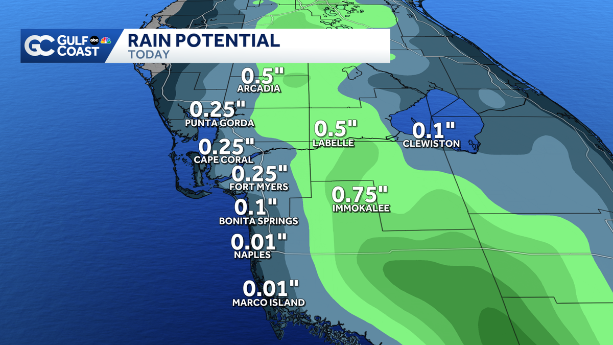
ANOTHER CHAMPIONSHIP. NEXT GAME IS TONIGHT AT 7 AT HERTZ ARENA. >> GULF COAST WEATHER CERTIFIED MOST ACCURATE. AND I KNOW WE’RE EXPECTING THAT RAIN LATER THIS AFTERNOON. THINK BY THE TIME THESE GAMES HAPPENED, WE’LL SEE THOSE DOWNPOURS. IT DEPENDS ON WHERE BECAUSE YESTERDAY WE HAD THOSE RAIN START EARLY IN THE AFTERNOON FOR SOME PEOPLE. BUT THAT ALSO LINGERED SO I DO WANT TO START WITH TALKING ABOUT RAINFALL TOTALS FROM YESTERDAY, JUST SO I CAN SHOW, YOU KNOW, WHO SAW THE WHO DIDN’T LOOK AT THE MAP. IT LIT UP. WE HAD HIGH RAIN CHANCES YESTERDAY. THEY VERIFY IT. I’D SAY SO. IF WE ZOOM INTO LEE COUNTY SPECIFICALLY, I WANT TO SHOW YOU A FEW OF THE HOT SPOTS DOWN THERE, ESPECIALLY IN THE SOUTHEASTERN CORNER OF THE COUNTY. LOOK AT THESE NUMBERS JUST SOUTH OF LEHIGH ACRES. 3.2 INCHES OF RADAR ESTIMATED RAINFALL JUST UNDER 2 INCHES OF RAIN ESTIMATED BEAR NEAR JETBLUE PARK, QUARTER OF AN INCH FIRST ARROW. SO A LOT LESS AND THEN HEAD OUT TO SANIBEL CAPTIVA. WE REALLY DON’T SEE A LOT OF RAIN OVER IN THE BARRIER ISLANDS ALSO MENTIONED THE SOUTHERN PART OF THE CAPE REALLY DIDN’T SEE MUCH. BUT THE NORTH EASTERN CORNER OF CAPE CORAL, THESE ARE JUST OVER AN INCH AND A HALF OF RAINFALL. AND SO I WILL MENTION THE COASTAL SIDE OF LAKE COUNTY. THEY HAVEN’T REALLY SEEN MUCH DROUGHT IMPROVEMENT OVER THE LAST COUPLE OF WEEKS VERSUS OTHER PARTS OF THE GULF COAST. SO WE NEED MORE RAIN THERE. WE COULD SEE THAT THERE THIS SATURDAY AFTERNOON. IF YOU LOOK AT THE NEXT COUPLE OF HOURS, OUR RAIN CHANCE THEY DO BUILDING UNTIL NOON AND THEN EVEN 1 O’CLOCK WE START TO BUMP THEM UP HIGHER AND HIGHER BY 3 O’CLOCK. WE PICK THAT RAIN CHANCE UP TO ABOUT 40% 60% BY 5 O’CLOCK. HOLD ON TO THAT. AS WE HEAD TOWARD SUNSET. SO WHAT DOES THAT MEAN FOR YOUR SATURDAY PLANS, WHETHER IT’S GOING OUT TO DOWNTOWN FORT MYERS PRIDE EVENT, OR IF YOU HAVE JUST DINNER RESERVATIONS ACROSS THE GULF COAST, THERE IS A CHANCE FOR RAIN. SO BE AWARE OF THAT POSSIBILITY. IT’S A GOOD IDEA TO KEEP THAT UMBRELLA RAINCOAT HANDY THIS AFTERNOON. SO WATCH. WE COULD SEE THAT RAIN FORM ALONG THE COAST EARLIER IN THE AFTERNOON. THIS BY ABOUT 1 O’CLOCK. THAT’S NOT HIGH COVERAGE TO JUST BE A STRAY CELL OR 2. BUT THEN LOOK, THE LATER WE GO INTO THE AFTERNOON HOURS. THIS IS 2.30 WE START TO SEE THAT RAIN DEVELOP A LITTLE BIT MORE INLAND AND THEN WE’LL CONTINUE TO SEE THAT COVERAGE BEEF UP. THIS IS BY 3.30, LOOK AT BY 4 O’CLOCK COULD SEE A STRONG CELL DOWN TOWARDS COLLIER COUNTY. SIMILAR TO WHAT WE HAD YESTERDAY PRODUCING GUSTY WINDS AND A WHOLE LOT OF LIGHTNING THERE TO HEAVY RAINFALL AS WELL. BUT THEN WHATEVER FORMS AS WE HEAD TOWARDS NIGHTFALL, THIS IS 5 O’CLOCK. THAT RAIN WILL START TO MEANDER ITS WAY BACK TOWARDS THE COASTLINE, 6 O’CLOCK. AND THEN WE GET TO 7 O’CLOCK. I MEAN, RIGHT ALONG THE I-75 CORRIDOR HERE, WHICH AGAIN COULD IMPACT YOUR SATURDAY NIGHT. DINNER PLANS, ESPECIALLY GOT A PATIO SPOT. SO KEEP THAT IN MIND BY 08:30PM, TONIGHT WILL STILL HAVE SOME RAIN ON THE RADAR, BUT IT DOES LIGHTEN UP. THE LATER WE GO INTO THE EVENING HOURS AND THEN IT SHOULD CLEAR ON OUT OF HERE WE HEAD INTO YOUR SUNDAY MORNING STARTING OFF DRY ONCE AGAIN. THAT’S ACTUALLY THE START OF US DRYING OUT ACROSS THE GULF COAST. AT LEAST A LITTLE BIT WILL NOT COMPLETELY GET RID OF THE RAIN CHANCES. WE WILL REALLY DO THAT FOR A WHILE ON THE GULF COAST. BUT 30 PER CENT COVERAGE BY MONDAY TUESDAY. WEDNESDAY WILL START TO PICK UP TOWARDS THE END OF THE WORKWEEK AND SOMETHING ELSE THAT WILL PICK UP OUR TEMPERATURE TREND. 95 DEGREES BY THURSDAY AND FRIDAY OF THIS NEXT WEEK. TODAY, OUR HIGH TEMPERATURES WILL BE CLOSER TO AVERAGE. THE AVERAGE AS HIGH AS 91. THAT’S WHAT I HAVE FOR US HERE IN FORT MYERS, UPPER 80’S ELSEWHERE. WE’RE STILL YET ANOTHER HOT DAY BEFORE WE WAIT FOR THOSE RAIN CHANCES DROP AND WE WAIT TO WARM UP ALONG THE GULF COAST. THEY COINCIDE WITH EACH OTHER. WHEN THOSE RAIN CHANCES DROP OUR TEMPERATURES START TO PICK UP BY THE MIDDLE PART OF THE WORKWEEK. AS FOR YOUR RAIN POTENTIAL SINCE WE DROP THOSE RAIN CHANCES, WE’RE EXPECTING LO
Saturday afternoon showers and storms bring more rain to the Gulf Coast

Updated: 7:27 AM EDT Jun 13, 2026
More rain is in the forecast to start your weekend off. Showers and thunderstorms are expected to develop across the Gulf Coast as temperatures climb Saturday afternoon.Your Gulf Coast Weather Most Accurate Forecast has a 60% chance of rain, and the highest rainfall totals will favor our inland locations east of I-75.Saturday has the highest rain chance for the next several days, as coverage starts to drop heading into next week. Besides the rain, temperatures stay close to average for the weekend as highs reach the upper 80s and lower 90s. By midweek, expect highs to reach the mid-90s as we turn up the heat even more.In the tropics, there is one area outlined by the National Hurricane Center in the southwestern Gulf with a low chance of development. An area of low pressure is forecast to move onshore, bringing rain to Mexico this weekend.However you watch or scroll, we’re committed to delivering your Gulf Coast Weather Most Accurate Forecast, one you can rely on every day, wherever you are.Live Interactive Radar: Track conditions in real time with the Gulf Coast Live Radar.Watch Gulf Coast Weather: Find the latest weather forecast videos, streaming live or on demand, on TV and online.Stream on the Go: Download the free Gulf Coast News app to watch on your phone or tablet.Your Gulf Coast Weather TeamChief Meteorologist Allyson RaeMeteorologist Caroline CastoraMeteorologist Jim DickeyMeteorologist Lauren HopeMeteorologist Raphael TavernierMeteorologist Rob DunsMeteorologist Sara BlueFollow on Social: Follow, like and subscribe to Gulf Coast News on social media to share your tips and be part of the conversation with Southwest Florida’s most experienced, trusted weather team: Facebook | Instagram | YouTube | TikTok | Threads | Bluesky | Nextdoor | XDOWNLOAD the free Gulf Coast News app for your latest breaking news and weather alerts. And check out the Very Local Gulf Coast app to stream news, entertainment and original programming on your TV.
FORT MYERS, Fla. —
More rain is in the forecast to start your weekend off. Showers and thunderstorms are expected to develop across the Gulf Coast as temperatures climb Saturday afternoon.
Your Gulf Coast Weather Most Accurate Forecast has a 60% chance of rain, and the highest rainfall totals will favor our inland locations east of I-75.
Saturday has the highest rain chance for the next several days, as coverage starts to drop heading into next week.
Besides the rain, temperatures stay close to average for the weekend as highs reach the upper 80s and lower 90s. By midweek, expect highs to reach the mid-90s as we turn up the heat even more.
In the tropics, there is one area outlined by the National Hurricane Center in the southwestern Gulf with a low chance of development. An area of low pressure is forecast to move onshore, bringing rain to Mexico this weekend.
However you watch or scroll, we’re committed to delivering your Gulf Coast Weather Most Accurate Forecast, one you can rely on every day, wherever you are.
Live Interactive Radar: Track conditions in real time with the Gulf Coast Live Radar.
Watch Gulf Coast Weather: Find the latest weather forecast videos, streaming live or on demand, on TV and online.
Stream on the Go: Download the free Gulf Coast News app to watch on your phone or tablet.
Your Gulf Coast Weather Team
Follow on Social: Follow, like and subscribe to Gulf Coast News on social media to share your tips and be part of the conversation with Southwest Florida’s most experienced, trusted weather team: Facebook | Instagram | YouTube | TikTok | Threads | Bluesky | Nextdoor | X
DOWNLOAD the free Gulf Coast News app for your latest breaking news and weather alerts. And check out the Very Local Gulf Coast app to stream news, entertainment and original programming on your TV.