
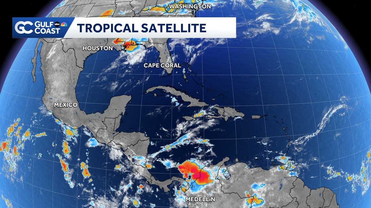
5.95 AT THE AVE MARIA WELCOME CENTER. ALL RIGHT, TRACKING THE TROPICS, GIVING YOU A LIVE AND VERY WET. LOOK AT NEW ORLEANS RIGHT NOW. YOU CAN SEE THE FLASHES OF LIGHTNING HAPPENING AND THE CAMERAS BLURRY BECAUSE OF ALL THE RAIN THAT IS ON THE LENS. SO. WHAT WAS ONCE TROPICAL STORM ARTHUR? THEY ARE STILL FEELING VERY SOGGY THIS MORNING BECAUSE OF THE AFTER EFFECT. ABSOLUTELY. THERE ARE TORNADO WARNINGS JUST SOUTH AND WEST OF NEW ORLEANS EARLIER ON THIS MORNING. THEY’RE GOING TO BE DEALING WITH SOME FLOODING RAINFALL. THEY’RE ALL FROM. >> WHAT’S LEFT OF OUR 3? IT MIGHT BE WONDERING, YOU KNOW, WHERE’S ARTHUR? RIGHT NOW? IT’S GONE BLINK AND YOU MISSED IT. IT WAS ONLY AROUND FOR ABOUT 12 HOURS FORMED YESTERDAY IN THE NORTHWEST SCHOOL FELL APART YESTERDAY EVENING OVER TEXAS. BUT THE REMNANT MOISTURE FROM THIS STILL PACKING A PUNCH. LOOK AT ALL OF THIS RAIN WORKING ITS WAY THROUGH NEW ORLEANS INTO PARTS OF MISSISSIPPI AND ALABAMA AND THE FLORIDA PANHANDLE THINGS ARE JUST BEGINNING HERE. THE GREEN POLYGON IS THOSE ARE VARIOUS TYPES OF FLOOD WARNINGS. FLASH FLOOD WARNINGS THAT WILL CONTINUE GOING THROUGH THE DAY TODAY GOING THROUGH MUCH OF THE DAY TOMORROW AS THIS BLOB OF HEAVY RAIN MOVES OFF TO THE NORTH AND EAST. LET THIS SERVE AS A REMINDER, EVEN A WEAK AND DISORGANIZED DISSIPATED. TROPICAL SYSTEM, CAN STILL PACK A PUNCH, ESPECIALLY WHEN IT COMES TO FLOODING RAINFALL WITH ALL THAT TROPICAL MOISTURE. THIS IS WORKING WITH THIS IS THE HIGHEST FLOOD RISK. THE NATIONAL WEATHER SERVICE PUTS OUT ON THIS PARTICULAR PRODUCT SAYING THAT FLOODING IS EXPECTED. MISSISSIPPI, ALABAMA NOSING INTO FLORIDA PANHANDLE. FEW FRIENDS IN THE PANHANDLE. IT’S GOING TO BE A DANGEROUS. 24 48 HOURS FLOODING ONGOING THERE. NOW, OF COURSE, YOU SEE ANYTHING LIKE THAT HERE LOCALLY, BUT WE COULD USE WE SOME RAIN TODAY TO HELP COOL THINGS DOWN. I JUST DON’T THINK WE’RE GOING TO SEE IT. YOU LOOK AT OUR RAIN TOTALS HERE LOCALLY THROUGH THE NEXT 24 HOURS. NOTHING GOING. 75 BACK TO THE
Former Tropical Storm Arthur brings flooding rain to northern Gulf Coast
Arthur is no longer a tropical storm, but it will continue to bring heavy rain and flooding the northern Gulf Coast Thursday.

Updated: 7:13 AM EDT Jun 18, 2026
The Gulf Coast News Hurricane Tracking team continues to monitor former Tropical Storm Arthur, which is now a Post-tropical cyclone, meaning it has lost its tropical characteristics. The National Hurricane Center issued its final advisory for the storm Wednesday evening, as the storm’s low-level circulation broke down over Texas. However, the remnant low-pressure area will continue to produce heavy rain and flooding along the northern Gulf Coast through the end of the week.Florida Weather ImpactsWhile this system poses no direct threat to South Florida, heavy rain from the storm will continue to soak the northern Gulf Coast, including the Florida Panhandle, on Thursday and Friday.The western Panhandle could see 5-7 inches of rain and a flooding threat over the next 48 hours. The system will also bring a tornado risk for parts of the Panhandle on Thursday.Use extreme caution if you’re planning to travel north Thursday and Friday, as heavy rain will target many communities across the southeastern U.S. This system poses no threat to the Florida peninsula. First Named Storm Arthur became our first named storm of the 2026 hurricane season when it formed on Wednesday. This falls closely in line with an average hurricane season, as the average date for the first named storm to form in the Atlantic is June 20. NOAA is forecasting a below-average season in the Atlantic this year, with 8 to 14 named storms forming by the end of the season in November. An average year sees 14 named storms form. The next name on this year’s list is Bertha.However you watch or scroll, we’re committed to delivering your Gulf Coast Weather Most Accurate Forecast, one you can rely on every day, wherever you are.Live Interactive Radar: Track conditions in real time with the Gulf Coast Live Radar.Watch Gulf Coast Weather: Find the latest weather forecast videos, streaming live or on demand, on TV and online.Stream on the Go: Download the free Gulf Coast News app to watch on your phone or tablet.Your Gulf Coast Weather TeamChief Meteorologist Allyson RaeMeteorologist Caroline CastoraMeteorologist Jim DickeyMeteorologist Lauren HopeMeteorologist Raphael TavernierMeteorologist Rob DunsMeteorologist Sara BlueFollow on Social: Follow, like, and subscribe to Gulf Coast News on social media to share your tips and be part of the conversation with Southwest Florida’s most experienced, trusted weather team: Facebook | Instagram | YouTube | TikTok | Threads | Bluesky | Nextdoor | XDOWNLOAD the free Gulf Coast News app for your latest breaking news and weather alerts. And check out the Very Local Gulf Coast app to stream news, entertainment, and original programming on your TV.
FORT MYERS, Fla. —
The Gulf Coast News Hurricane Tracking team continues to monitor former Tropical Storm Arthur, which is now a Post-tropical cyclone, meaning it has lost its tropical characteristics.
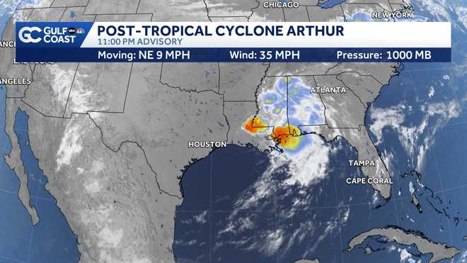
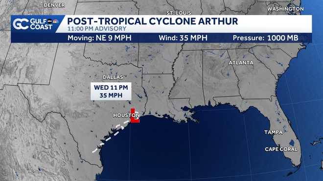
The National Hurricane Center issued its final advisory for the storm Wednesday evening, as the storm’s low-level circulation broke down over Texas. However, the remnant low-pressure area will continue to produce heavy rain and flooding along the northern Gulf Coast through the end of the week.
Florida Weather Impacts
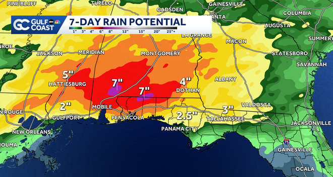
While this system poses no direct threat to South Florida, heavy rain from the storm will continue to soak the northern Gulf Coast, including the Florida Panhandle, on Thursday and Friday.
The western Panhandle could see 5-7 inches of rain and a flooding threat over the next 48 hours. The system will also bring a tornado risk for parts of the Panhandle on Thursday.
Use extreme caution if you’re planning to travel north Thursday and Friday, as heavy rain will target many communities across the southeastern U.S. This system poses no threat to the Florida peninsula.
First Named Storm
Arthur became our first named storm of the 2026 hurricane season when it formed on Wednesday. This falls closely in line with an average hurricane season, as the average date for the first named storm to form in the Atlantic is June 20. NOAA is forecasting a below-average season in the Atlantic this year, with 8 to 14 named storms forming by the end of the season in November. An average year sees 14 named storms form.
The next name on this year’s list is Bertha.
However you watch or scroll, we’re committed to delivering your Gulf Coast Weather Most Accurate Forecast, one you can rely on every day, wherever you are.
Live Interactive Radar: Track conditions in real time with the Gulf Coast Live Radar.
Watch Gulf Coast Weather: Find the latest weather forecast videos, streaming live or on demand, on TV and online.
Stream on the Go: Download the free Gulf Coast News app to watch on your phone or tablet.
Your Gulf Coast Weather Team
Follow on Social: Follow, like, and subscribe to Gulf Coast News on social media to share your tips and be part of the conversation with Southwest Florida’s most experienced, trusted weather team: Facebook | Instagram | YouTube | TikTok | Threads | Bluesky | Nextdoor | X
DOWNLOAD the free Gulf Coast News app for your latest breaking news and weather alerts. And check out the Very Local Gulf Coast app to stream news, entertainment, and original programming on your TV.