
Very humid Tuesday with inland storms
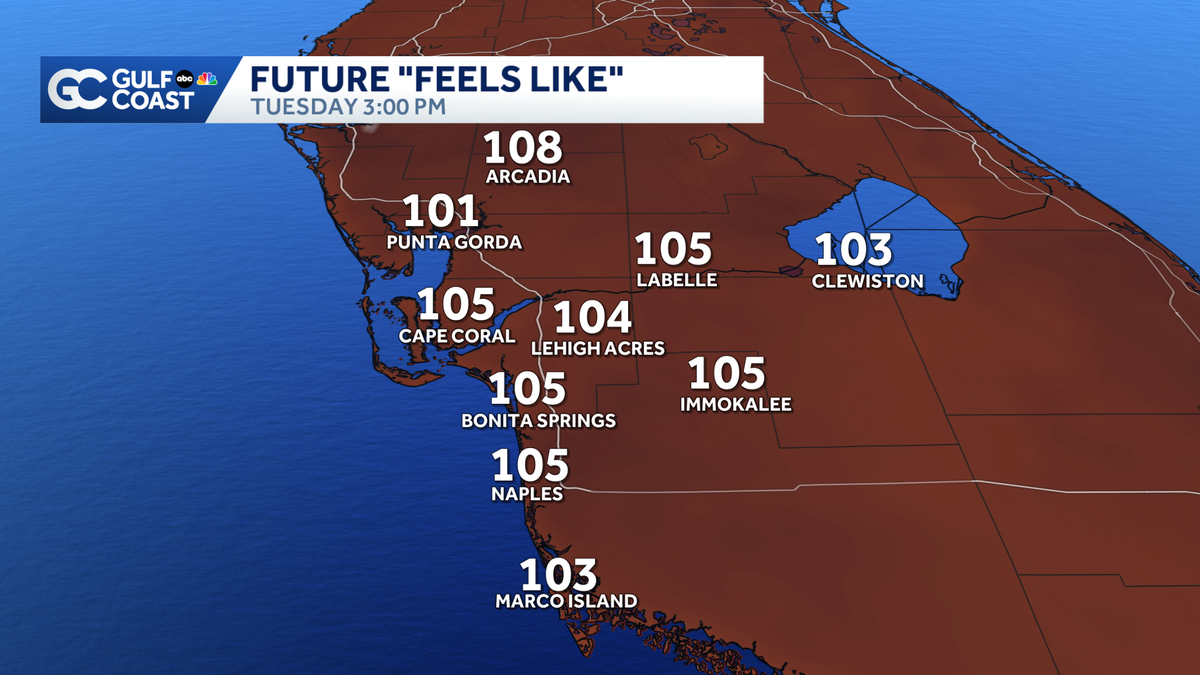
Get ready for a steamy afternoon with feels like temperatures in the triple digits.
OF SAY, YOU KNOW WHAT, THIS IS JUST PART OF THE MIAMI AS NEXT HOUR. >> CERTIFIED MOST ACCURATE NOT USED TO THE WEATHER THAT WE HAVE HERE. THOSE ARE SOME TRUE FANS I GOTTA AND IT HAS BEEN SO SO HOT. WE KNOW IT’S JUNE, BUT IT HAS BEEN ABOVE AVERAGE. AND YOU FACTOR IN THE HIGH HUMIDITY AND THAT IS WHAT’S MAKING ALL THE DIFFERENCE. WE’VE GOT AN ONSHORE WIND TODAY. >> THAT IS DRIVING IN HIGHER HUMIDITY LATER THIS AFTERNOON. SO FEELS LIKE TEMPERATURES LOOK AT THIS 108, ARCADIA WHILE 5 CAPE CORAL. IT IS GONNA BE A DAY WHERE YOU NEED TO TAKE THE HEAT SERIOUSLY ALL OVER AGAIN. NOW WE DON’T TECHNICALLY BEAT THAT AND A CRITERIA FOR A HEAT ADVISORY, BUT WE’RE JUST SHY OF THE CRITERIA. SO THERE’S NOT SIGNIFICANT RELIEF ON THE WAY EITHER. EVEN LOOKING AHEAD TO THE FIRST WEEK OF JULY ACROSS THE ENTIRE GULF COAST, WE’RE STICKING WITH ABOVE AVERAGE TEMPERATURES FEELING AS HOT AS THE TRIPLE DIGITS. NOT JUST TODAY, EVERY SINGLE DAY THROUGH THE REST OF THE WORKWEEK HEADING INTO THE WEEKEND. NOT SEEING A WHOLE LOT OF RELIEF. SO WE COULD SEE HEAT ADVISORIES ISSUED AT TIMES. THE BEST BET FOR THAT IS EITHER GOING TO BE LATER THIS AFTERNOON OR EVEN FOR THE 1ST HALF OF THIS WEEKEND. SO AT LEAST SOME COMMUNITIES GETTING IN ON THE STORMS, THOUGH, NOT EVERYONE WILL BE DEALING WITH THE HEAT ALL DAY. STARTING TO SEE A COUPLE OF SHOWERS DEVELOPING AROUND 1, 2 O’CLOCK MAINLY INITIALLY NEAR. I-75 ONCE THAT ONSHORE WIND REALLY STARTS TO KICK IN. THIS IS GOING TO BE DRIVING A LOT OF THUNDERSTORM ACTIVITY, MAINLY EAST OF I-75 SO HEADING INTO HENDRY AND GLADES COUNTIES, DOWNPOURS, LIGHTNING WILL BE THE 2 BIGGEST THREATS HEADING INTO TONIGHT. OTHERWISE JUST ISOLATED STORM COVERAGE. AND IF YOU ARE GOING TO BE CLOSER COASTAL SPOTS, YOU’RE JUST STUCK WITH THE HEAT. AND WE’VE GOT ANOTHER HOT DAY ON TAP WITH HIGHS AROUND. 94 WERE DOWN INTO THE UPPER 70’S OVERNIGHT. AND THEN BACK TO THE 90’S. EVERY SINGLE AFTERNOON. AND THEN NOT NECESSARILY RECORD HEAT, BUT ABOVE AVERAGE. 95 FRIDAY, SATURDAY, SUNDAY LOOKING A VERY TOASTY AS WELL. LOOKING AHEAD TO THE WEEKEND AND MORNING, STILL A SLIGHTLY ABOVE AVERAGE IN THE UPPER 70’S. HERE’S THE GOOD NEWS AS YOU GET YOUR MORNING. STARTED TRACKING THE TROPICS. BUT NOTHING OUT THERE. THERE’S NO DEVELOPMENT EXPECTED OVER THE NEXT WEEK. OF COURSE, THERE WAS TROPICAL STORM ARTHUR AND NOW THE NEXT NAME ON THE LIST IS BERTHA, BUT NOT SEEING ANY AREAS OF INTEREST. ONE OF THE MAIN REASONS THE TROPICS ARE SO QUIET IS A VERY COMMON COLD FOR THIS TIME OF YEAR AT THE SAHARAN DUST AND WE’RE SEEING A HUGE DENSE PLUME TRACKING ACROSS THE ATLANTIC BASIN THIS WEEK HELPING TO SUPPRESS THAT MOISTURE THAT YOU NEED FOR TROPICAL DEVELOPMENT COULD SEE SOME MEDIUM CONCENTRATIONS WORKING INTO THE GULF COAST. THAT WOULDN’T BE UNTIL THIS WEEKEND. THAT COULD HELD TO SLIGHTLY DECREASE OR LOCAL RAIN CHANCES. BUT IT WOULDN’T BE UNTIL SATURDAY AND SUNDAY. MOST IMPORTANTLY, THIS IS KNOWN TO SUPPRESS TROPICAL ACTIVITY WILL CONTINUE TO TRACK THIS PLUME BECAUSE THOSE OF YOU THAT DO SUFFER FROM RESPIRATORY ISSUES MIGHT SEE THAT IRRITATED SATURDAY AND SUNDAY AS THAT MOVES IN. BUT OTHERWISE, IT IS STILL ALL ABOUT THE HEAT THIS WEEKEND. WE ARE STILL GOING TO BE STUCK IN
Very humid Tuesday with inland storms
Get ready for a steamy afternoon with feels like temperatures in the triple digits.

Updated: 5:07 AM EDT Jun 23, 2026
We’re in store for a steamy Tuesday as humidity remains elevated with afternoon highs in the low 90s. Your Gulf Coast Weather Most Accurate Forecast has isolated showers and storms developing by the late afternoon. An onshore wind will drive the storm activity inland, mainly favoring areas east of I-75. The biggest threats will be heavy rain and lightning. After sunset, storms will wind down with lows staying above average in the upper 70s. Highs will remain in the 90s through the rest of the week with daily afternoon storm chances. In the tropics, no development is expected over the next seven days. Dense plumes of Saharan dust is helping to suppress activity across the Atlantic basin. The next name on the list is Bertha. However you watch or scroll, we’re committed to delivering your Gulf Coast Weather Most Accurate Forecast, one you can rely on every day, wherever you are.Live Interactive Radar: Track conditions in real time with the Gulf Coast Live Radar.Watch Gulf Coast Weather: Find the latest weather forecast videos, streaming live or on demand, on TV and online.Stream on the Go: Download the free Gulf Coast News app to watch on your phone or tablet.Your Gulf Coast Weather TeamChief Meteorologist Allyson RaeMeteorologist Caroline CastoraMeteorologist Jim DickeyMeteorologist Lauren HopeMeteorologist Raphael TavernierMeteorologist Rob DunsMeteorologist Sara BlueFollow on Social: Follow, like and subscribe to Gulf Coast News on social media to share your tips and be part of the conversation with Southwest Florida’s most experienced, trusted weather team: Facebook | Instagram | YouTube | TikTok | Threads | Bluesky | Nextdoor | XDOWNLOAD the free Gulf Coast News app for your latest breaking news and weather alerts. And check out the Very Local Gulf Coast app to stream news, entertainment and original programming on your TV.
FORT MYERS, Fla. —
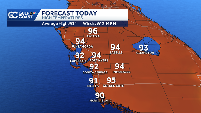
We’re in store for a steamy Tuesday as humidity remains elevated with afternoon highs in the low 90s.
Gulf Coast News
Today’s Highs
Your Gulf Coast Weather Most Accurate Forecast has isolated showers and storms developing by the late afternoon. An onshore wind will drive the storm activity inland, mainly favoring areas east of I-75. The biggest threats will be heavy rain and lightning. After sunset, storms will wind down with lows staying above average in the upper 70s.
Highs will remain in the 90s through the rest of the week with daily afternoon storm chances.
In the tropics, no development is expected over the next seven days. Dense plumes of Saharan dust is helping to suppress activity across the Atlantic basin. The next name on the list is Bertha.
However you watch or scroll, we’re committed to delivering your Gulf Coast Weather Most Accurate Forecast, one you can rely on every day, wherever you are.
Live Interactive Radar: Track conditions in real time with the Gulf Coast Live Radar.
Watch Gulf Coast Weather: Find the latest weather forecast videos, streaming live or on demand, on TV and online.
Stream on the Go: Download the free Gulf Coast News app to watch on your phone or tablet.
Your Gulf Coast Weather Team
Follow on Social: Follow, like and subscribe to Gulf Coast News on social media to share your tips and be part of the conversation with Southwest Florida’s most experienced, trusted weather team: Facebook | Instagram | YouTube | TikTok | Threads | Bluesky | Nextdoor | X
DOWNLOAD the free Gulf Coast News app for your latest breaking news and weather alerts. And check out the Very Local Gulf Coast app to stream news, entertainment and original programming on your TV.