

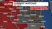
A few showers and cloud cover will keep temperatures still tolerable on Sunday but starting Monday, dangerous heat moves on in. How hot we’ll be and when heat may start to leave southern Wisconsin here.
COPYRIGHT 2026 BY CHANNEL 3000. ALL RIGHTS RESERVED. THIS MATERIAL MAY NOT BE PUBLISHED, BROADCAST, REWRITTEN OR REDISTRIBUTED.
Download the First Warn Weather app here
WHAT WE’RE TRACKING:
Quiet conditions Saturday nightA bit cloudier on Sunday with an isolated rain/storm chanceDangerous heat arrives Monday

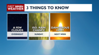
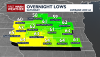
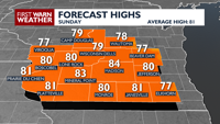
NEXT 24 HOURS: Quiet conditions are expected overnight Saturday into Sunday as lows dip into the low to mid 60s. Winds are going to remain light out of the east then turn southeast and pick up in speed throughout Sunday. Clouds are going to increase throughout Sunday morning as left over showers and thunderstorms move through Minnesota into mainly northern parts of Wisconsin. The cloud cover will keep temperatures in the low to mid 80s despite the breezy conditions. A few showers/storms may be possible otherwise, most will stay quiet.
COPYRIGHT 2026 BY CHANNEL 3000. ALL RIGHTS RESERVED. THIS MATERIAL MAY NOT BE PUBLISHED, BROADCAST, REWRITTEN OR REDISTRIBUTED.
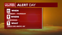
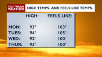
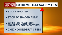
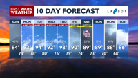
EXTENDED FORECAST: Starting Monday through Thursday of next week, ALERT DAY conditions are expected; temperatures will climb into the low to mid 90s with heat index values expected to range between 100-110°F. Next week, make sure that you’re drinking plenty of water to stay hydrated and stay cool if you’re outside during the day and while you’re sleeping. There will be chances for showers and thunderstorms next week, but due to the heat, most of the rain activity will likely take place during the evening and night time hours. There will be some relief by the time of the 4th however, temperatures will still remain in the mid 80s.
COPYRIGHT 2026 BY CHANNEL 3000. ALL RIGHTS RESERVED. THIS MATERIAL MAY NOT BE PUBLISHED, BROADCAST, REWRITTEN OR REDISTRIBUTED.
Humidity: 78%
Feels Like: 65°
Heat Index: 65°
Wind: 4 mph
Wind Chill: 65°
UV Index: 0 Low
Sunrise: 05:20:36 AM
Sunset: 08:41:47 PM
Dew Point: 58°
Visibility: 10 mi
Today
Partly cloudy with a slight chance of showers.
Wind: E 5 MPH
Tonight
Partly cloudy with a slight chance of showers.
Wind: E 5 MPH
Tomorrow
Variable cloudiness and breezy with a chance for showers and thunderstorms. Wind: SE 10-15 MPH.
Sat
Saturday
78°/61°
Mostly clear. Lows overnight in the low 60s.
Saturday Night
Partly cloudy with a slight chance of showers.
Wind: E 5 MPH
Sun
Sunday
84°/74°
Partly cloudy, chance of a thunderstorm. Highs in the low 80s and lows in the mid 70s.
Sunday Night
Breezy with a chance for showers and thunderstorms. Wind: SE 10-15 MPH.
Mon
Monday
93°/78°
Times of sun and clouds. Highs in the low 90s and lows in the upper 70s.
Monday Night
Mostly clear, hot and breezy.
Tue
Tuesday
94°/80°
Times of sun and clouds. Highs in the low 90s and lows in the mid 70s.
Tuesday Night
Mostly clear and hot with a slight chance for showers and thunderstorms.
Wed
Wednesday
92°/76°
Sunshine. Highs in the low 90s and lows in the low 70s.
Wednesday Night
Mostly clear.
Thu
Thursday
93°/75°
Afternoon showers and thunderstorms. Highs in the upper 80s and lows in the low 70s.
Thursday Night
Partly cloudy with a chance of showers and thunderstorms.
Fri
Friday
90°/74°
Scattered thunderstorms possible. Highs in the mid 80s and lows in the upper 60s.
Friday Night
Partly cloudy with a slight chance of showers and thunderstorms.
Sat
Saturday
89°/73°
Scattered thunderstorms. Highs in the mid 80s and lows in the upper 60s.
Saturday Night
Partly cloudy.
Sun
Sunday
89°/70°
Partly cloudy. Highs in the mid 80s and lows in the upper 60s.
Sunday Night
Partly to mostly cloudy.
Mon
Monday
88°/68°
Partly cloudy. Highs in the mid 80s and lows in the mid 60s.
Monday Night
Mostly cloudy with a chance for showers and thunderstorms.