

COPYRIGHT 2026 BY CHANNEL 3000. ALL RIGHTS RESERVED. THIS MATERIAL MAY NOT BE PUBLISHED, BROADCAST, REWRITTEN OR REDISTRIBUTED.
Download the First Warn Weather app here
WHAT WE’RE TRACKING:

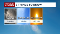
Storms Ending OvernightA Few Storms ThursdayTurning Hot & Humid Next Week
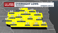
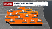
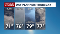
NEXT 24 HOURS: Storms continue to weaken with the risks transitioning to heavy rainfall from any isolated shower or storm that remains Wednesday night. Lows tonight will be muggy in the upper 60s. There is a chance of showers and thunderstorms throughout the day Thursday, especially in the afternoon, and we’ll see high temperatures around 80.
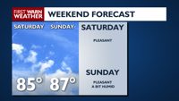
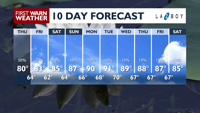
EXTENDED FORECAST: Friday and Saturday will be beautiful summer days with plenty of sun and highs in the low-mid 80s. Heat and humidity will start to build in Sunday and peak into next week. Highs are expected to be near or above 90 much of next week!
COPYRIGHT 2026 BY CHANNEL 3000. ALL RIGHTS RESERVED. THIS MATERIAL MAY NOT BE PUBLISHED, BROADCAST, REWRITTEN OR REDISTRIBUTED.
Humidity: 70%
Feels Like: 77°
Heat Index: 77°
Wind: 8 mph
Wind Chill: 77°
UV Index: 0 Low
Sunrise: 05:26:46 AM
Sunset: 08:39:19 PM
Dew Point: 67°
Visibility: 9 mi
Today
Mostly cloudy with scattered showers and thunderstorms. A few storms may be strong to severe.
Wind: S 5-10 MPH
Tonight
Mostly cloudy with scattered showers and thunderstorms. A few storms may be strong to severe.
Wind: S 5-10 MPH
Tomorrow
Mostly cloudy with a chance of showers and thunderstorms.
Wind: W 5-10 MPH
Wed
Wednesday
87°/69°
Periods of light rain. Lows overnight in the upper 60s.
Wednesday Night
Mostly cloudy with scattered showers and thunderstorms. A few storms may be strong to severe.
Wind: S 5-10 MPH
Thu
Thursday
80°/63°
Cloudy. Highs in the low 80s and lows in the mid 60s.
Thursday Night
A chance of showers and thunderstorms, mainly early. Wind: CALM
Fri
Friday
83°/62°
Partly cloudy. Highs in the low 80s and lows in the low 60s.
Friday Night
Partly cloudy with a slight chance of a shower late, mainly near the Wisconsin-Illinois state line. Some patchy fog is possible.
Wind: CALM
Sat
Saturday
85°/64°
Abundant sunshine. Highs in the upper 80s and lows in the mid 60s.
Saturday Night
Partly cloudy and seasonable.
Sun
Sunday
86°/66°
Sunshine. Highs in the low 90s and lows in the upper 60s.
Sunday Night
Partly cloudy and muggy.
Mon
Monday
88°/69°
Plenty of sun. Highs in the low 90s and lows in the upper 60s.
Monday Night
Partly cloudy and muggy.
Tue
Tuesday
90°/70°
More sun than clouds. Highs in the low 90s and lows in the upper 60s.
Tuesday Night
Partly cloudy and muggy.
Wed
Wednesday
88°/67°
Times of sun and clouds. Highs in the low 90s and lows in the upper 60s.
Wednesday Night
Partly cloudy and muggy.
Thu
Thursday
87°/67°
Mix of sun and clouds. Highs in the upper 80s and lows in the upper 60s.
Thursday Night
Partly cloudy and muggy.
Fri
Friday
87°/67°
Partly cloudy. Highs in the upper 80s and lows in the upper 60s.
Friday Night
Partly cloudy and muggy.