
Impact Day: Rain Returns this Afternoon, Flood Watch
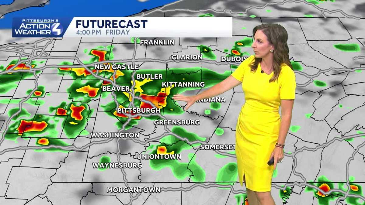
Uh, right now you can see that into Beaver. Even western portions of Allegheny County, southern Butler, very light. The good thing is it is weakening as it continues to move into our direction. But yes, we’re going to need those umbrellas to see *** little bit of *** batch just moving into Wexford and Pine Township, taking over most of Beaver again in northern Washington County this morning. Now as we continue through the day, the storms are going to start to ramp up, and there is *** marginal risk, *** level 1 out of 5, for some of those storms to turn severe. So what that means is we Could have some stronger wind gusts trying to develop with any storm pushing through, but like we’ve seen over the past couple of weeks, unfortunately is the heavy downpours associated with any storm edging through the area. So looking at our future cast, picking up still around 6 o’clock, that rain that’s in Ohio still lingering into Beaver, Butler, parts of Allegheny that will clip into Armstrong and Indiana as we get around 12, 1 o’clock. This is when we’re going to start to see some of those pockets of heavy rain. We’ve got the heat, we’ve got the humidity, and that front edging *** little bit. Closer, widely scattered here as we get closer to 34 o’clock, it’s going to intensify *** bit into Allegheny, Beaver, Lawrence up into the Butler and Armstrong extending down into Fayette County, continuing to move east southeastward, still around 67 o’clock. Can’t rule out some heavy rainfall, something we’ll really be watching into Washington County where we’ve had *** lot of flash flooding even into Greene and Fayette County. After sunset, it starts to weaken and calm down. Now as we get into Saturday. Waking up to some areas of patchy fog, and we will have clouds and some sunshine. Small chance for *** shower or storm to try to pop up. Looks to be non-severe. This is around 7 o’clock Saturday evening. Could be on the fringe there on the border of Armstrong, Indiana, even into Westmoreland. So very, very isolated. I don’t think it’s *** weekend you need to change your outdoor plans, but you definitely need to be aware. It’s *** good time to get our WTA up. So we’ll notify you if anything is in your, in your area. Flood watch now in place until 10 o’clock tonight. This is for the entire region. That’s because if we have some of those storm cells sitting over your area with that heavy downpour, there is that potential as the ground is already so saturated to have some localized flooding. We’re going to stay in the low to mid 80s heading into the weekend. The best part is the humidity is going to drop. As we get into Sunday, right now we’re in the upper 60s and low 70s. You will feel it. It is very muggy out there already. Impact day with rain and storms. Again, *** chance for *** few showers, possibly ***, *** non-severe thunderstorm Saturday afternoon. Can’t stress this enough. I really think most of the region will stay dry. It’s really going to heat back up and stay dry into next week as we get back into the 90s.
Rain and storms return today. We also stay on the muggy side with humidity gradually dropping over the weekend.Impact Day – Scattered Storms, Flood WatchRain and storms returning today.A few showers passing this morning, but the bulk of the scattered rain and storms returns this afternoon and evening. Storms will produce heavy rainfall and some gusty winds. Rain should come to an end as we get close to sunset. By the time rain is done late on Friday, some localized locations could pick up over an inch of rain, leading to localized flooding concerns which is why the entire region is under a Flood Watch until 10 pm. Weekend Dries Out, Warming Up Next WeekShower chances may be possible this weekend, but any rain will be battling a ridge of high pressure setting up again across the area. Saturday is our chance to see some rain, but it looks to remain very isolated in the afternoon. Our dry stretch with sunshine will begin on Sunday and last through the week. It will get warmer. We will see 90° during the middle and later part of next week.TODAY – Impact Day: Sct’d rain & storms, flood watch until 10pm. High: 83°.TONIGHT: Evening storms ending. Patchy fog late. Low 68°.SATURDAY: Sun & clouds, with a few showers. High: 83°, low: 64°.SUNDAY: Mostly sunny, less humid. High: 85°, low: 65°.
Rain and storms return today. We also stay on the muggy side with humidity gradually dropping over the weekend.
Impact Day – Scattered Storms, Flood Watch
Rain and storms returning today.
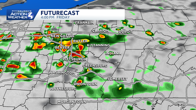
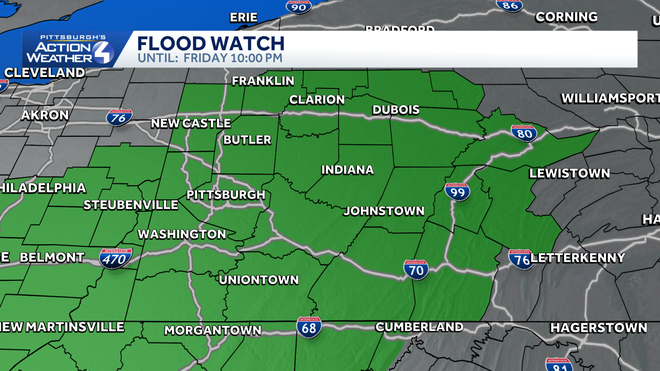
A few showers passing this morning, but the bulk of the scattered rain and storms returns this afternoon and evening. Storms will produce heavy rainfall and some gusty winds. Rain should come to an end as we get close to sunset. By the time rain is done late on Friday, some localized locations could pick up over an inch of rain, leading to localized flooding concerns which is why the entire region is under a Flood Watch until 10 pm.
Weekend Dries Out, Warming Up Next Week
Shower chances may be possible this weekend, but any rain will be battling a ridge of high pressure setting up again across the area. Saturday is our chance to see some rain, but it looks to remain very isolated in the afternoon. Our dry stretch with sunshine will begin on Sunday and last through the week. It will get warmer. We will see 90° during the middle and later part of next week.
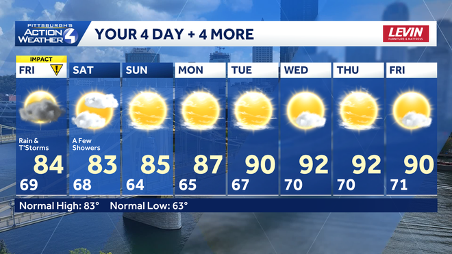
TODAY – Impact Day: Sct’d rain & storms, flood watch until 10pm. High: 83°.
TONIGHT: Evening storms ending. Patchy fog late. Low 68°.
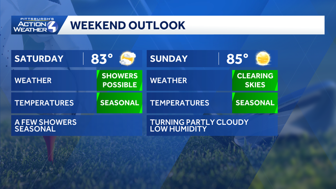
SATURDAY: Sun & clouds, with a few showers. High: 83°, low: 64°.
SUNDAY: Mostly sunny, less humid. High: 85°, low: 65°.