Tropical Storm Erin has formed in the eastern tropical Atlantic.As of the 5pm advisory, the system is currently moving west at 21 mph with maximum sustained winds of 45 mph. The initial track forecast from the NHC indicates that the storm will continue on a westerly track this week, gradually intensifying as it does. The storm is forecast to become the first hurricane of 2025 by Wednesday. It is forecast to become the first major hurricane, reaching category 3 strength, as it tracks north of the Caribbean by the weekend. Models are in decent agreement that the storm will stay north of the Caribbean and then turn north prior to reaching the Bahamas. This would keep the storm away from the United States and Florida.However, it is still too early to determine the exact path and track of this storm, so stay with the Gulf Coast Storm Team as we continue to monitor Erin for you throughout the week.Area in the Gulf and elsewhereOther areas to watch in the tropics are less likely to amount to anything. There are three other spots to watch including a new area in the Gulf that brought us rain yesterday.That area in the Gulf has a 0% chance of formation over the next two and seven days. A weak surface trough is responsible for this, and while formation isn’t expected, heavy rain could lead to flooding in the panhandle from this setup. Invest 96LAnother area, designated Invest 96L, is a weak and disorganized area of low pressure that is drifting north in the central Atlantic. It has a low chance to develop into a tropical depression as it continues to move northward this week. Regardless, it is not a threat to land.Non-tropical lowA non-tropical low to the south of Nova Scotia will be monitored for tropical development in the coming days as well. The NHC gives this system a low chance of taking on tropical characteristics as it swirls over the warm waters of the Gulf Stream this week. Regardless, it too is no threat to land. The Atlantic hurricane season runs from June 1 through Nov. 30. Follow Gulf Coast News online and on air for Southwest Florida’s Most Accurate weather forecast.Be prepared with the Gulf Coast News 2025 Hurricane GuideLive Interactive RadarCheck out the interactive Gulf Coast Live RadarWatch your Gulf Coast Weather forecasts on TV or onlineHere’s where to find our latest weather forecast videoYou can also watch newscasts live or on demand hereOr download the Gulf Coast News app to stream on your phone or tabletFollow the Gulf Coast Storm Team on social mediaChief Meteorologist Allyson Rae on Facebook and XMeteorologist Caroline Castora on Facebook and XMeteorologist Jim Dickey on Facebook and XMeteorologist Jason Dunning on Facebook and XMeteorologist Rob Duns on Facebook and XMeteorologist Lauren Hope on Facebook and XMeteorologist Raphael Tavernier on Facebook and XDOWNLOAD the free Gulf Coast News app for your latest breaking news and weather alerts. And check out the Very Local Gulf Coast app to stream news, entertainment and original programming on your TV.
FORT MYERS, Fla. —
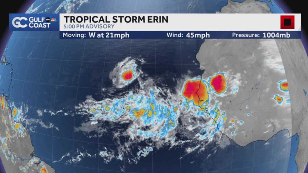
Tropical Storm Erin has formed in the eastern tropical Atlantic.
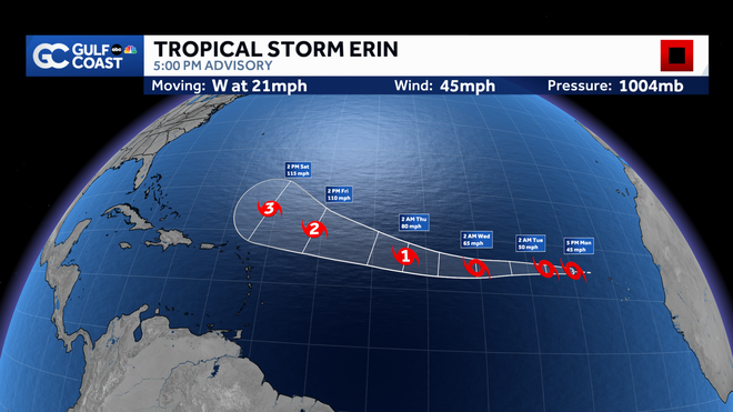
As of the 5pm advisory, the system is currently moving west at 21 mph with maximum sustained winds of 45 mph.
Gulf Coast News
5 pm advisory
The initial track forecast from the NHC indicates that the storm will continue on a westerly track this week, gradually intensifying as it does. The storm is forecast to become the first hurricane of 2025 by Wednesday. It is forecast to become the first major hurricane, reaching category 3 strength, as it tracks north of the Caribbean by the weekend.
Models are in decent agreement that the storm will stay north of the Caribbean and then turn north prior to reaching the Bahamas. This would keep the storm away from the United States and Florida.
However, it is still too early to determine the exact path and track of this storm, so stay with the Gulf Coast Storm Team as we continue to monitor Erin for you throughout the week.
Area in the Gulf and elsewhere
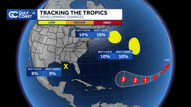
Other areas to watch in the tropics are less likely to amount to anything. There are three other spots to watch including a new area in the Gulf that brought us rain yesterday.
Gulf Coast News
Tracking the tropics
That area in the Gulf has a 0% chance of formation over the next two and seven days. A weak surface trough is responsible for this, and while formation isn’t expected, heavy rain could lead to flooding in the panhandle from this setup.
Invest 96L
Another area, designated Invest 96L, is a weak and disorganized area of low pressure that is drifting north in the central Atlantic. It has a low chance to develop into a tropical depression as it continues to move northward this week. Regardless, it is not a threat to land.
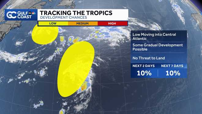
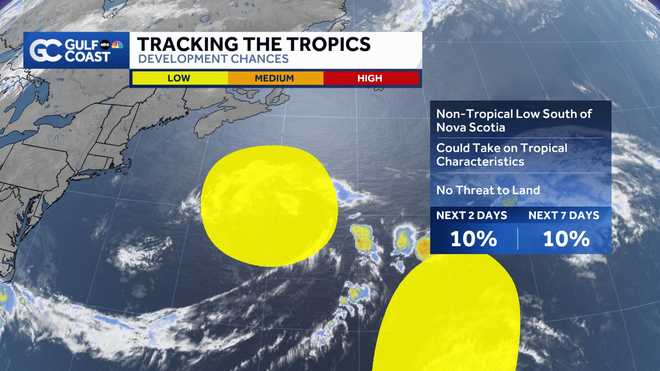
Non-tropical low
A non-tropical low to the south of Nova Scotia will be monitored for tropical development in the coming days as well. The NHC gives this system a low chance of taking on tropical characteristics as it swirls over the warm waters of the Gulf Stream this week. Regardless, it too is no threat to land.
The Atlantic hurricane season runs from June 1 through Nov. 30. Follow Gulf Coast News online and on air for Southwest Florida’s Most Accurate weather forecast.
Live Interactive Radar
Watch your Gulf Coast Weather forecasts on TV or online
Follow the Gulf Coast Storm Team on social media
Chief Meteorologist Allyson Rae on Facebook and XMeteorologist Caroline Castora on Facebook and XMeteorologist Jim Dickey on Facebook and XMeteorologist Jason Dunning on Facebook and XMeteorologist Rob Duns on Facebook and XMeteorologist Lauren Hope on Facebook and XMeteorologist Raphael Tavernier on Facebook and X
DOWNLOAD the free Gulf Coast News app for your latest breaking news and weather alerts. And check out the Very Local Gulf Coast app to stream news, entertainment and original programming on your TV.

