
Today is a Severe Weather Alert Day in western Pennsylvania.A cold front will bring the potential for strong-to-severe storms Saturday afternoon and evening. Parts of the area are included in a Flood Watch through midnight. WATCH PREVIOUS WEATHERCAST IN PLAYFINDER ABOVE Severe Thunderstorm WatchAll of Western Pennsylvania remains under a Severe Thunderstorm Watch Saturday. The National Weather Service says the watch will remain in place until 9 p.m. More: Get severe weather alerts for your countyInteractive radar: Track storms as they move through your areaLearn how to enable automatic weather alerts on the WTAE appFlash Flood Warning A Flash Flood Warning has been issued for parts of Western Pennsylvania on Saturday. Allegheny County is under the warning until 7 p.m., as Westmoreland County remains under the warning until 8:15 p.m. Some locations that will experience flash flooding include… Monroeville, Murrysville, North Versailles, Wilkins Township, Turtle Creek, Pitcairn, Trafford, Delmont, Wilmerding, East Pittsburgh, Export, Wall and SlickvilleOfficials urge drivers to turn around if a road appears to be flooded. Flood Watch Parts of Western Pennsylvania also remain under a Flood Watch due to expected severe thunderstorms in the area. Portions of Pennsylvania, including the following areas: Armstrong, Clarion, Fayette, Higher Elevations of Fayette, Higher Elevations of Indiana, Higher Elevations of Westmoreland, Indiana, Jefferson PA, and Westmoreland and northern West Virginia, including the following areas: Eastern Preston and Preston, are under the watch until late Saturday evening. Severe Weather Alert Day: Late-day strong stormsSpotty showers will be off and on throughout the day. Rain may be heavy at times, especially in any thunderstorms, with some locations potentially picking up close to inch of rain. We will watch for a severe threat after 4 p.m. through sunset as a line of storms move south. Areas north of Pittsburgh are at a greater risk for severe weather.A Flood Watch is now in effect until midnight for Armstrong, Clarion, Fayette, Indiana and Westmoreland counties along with Preston and Garrett. Runoff following the late-day heavy rain could lead to flash flooding and rises of creeks and streams.Damaging wind and flooding are the primary concerns. Hail and tornadoes are a lower, but non-zero threat with this line.
Today is a Severe Weather Alert Day in western Pennsylvania.
A cold front will bring the potential for strong-to-severe storms Saturday afternoon and evening. Parts of the area are included in a Flood Watch through midnight.
WATCH PREVIOUS WEATHERCAST IN PLAYFINDER ABOVE
Severe Thunderstorm Watch
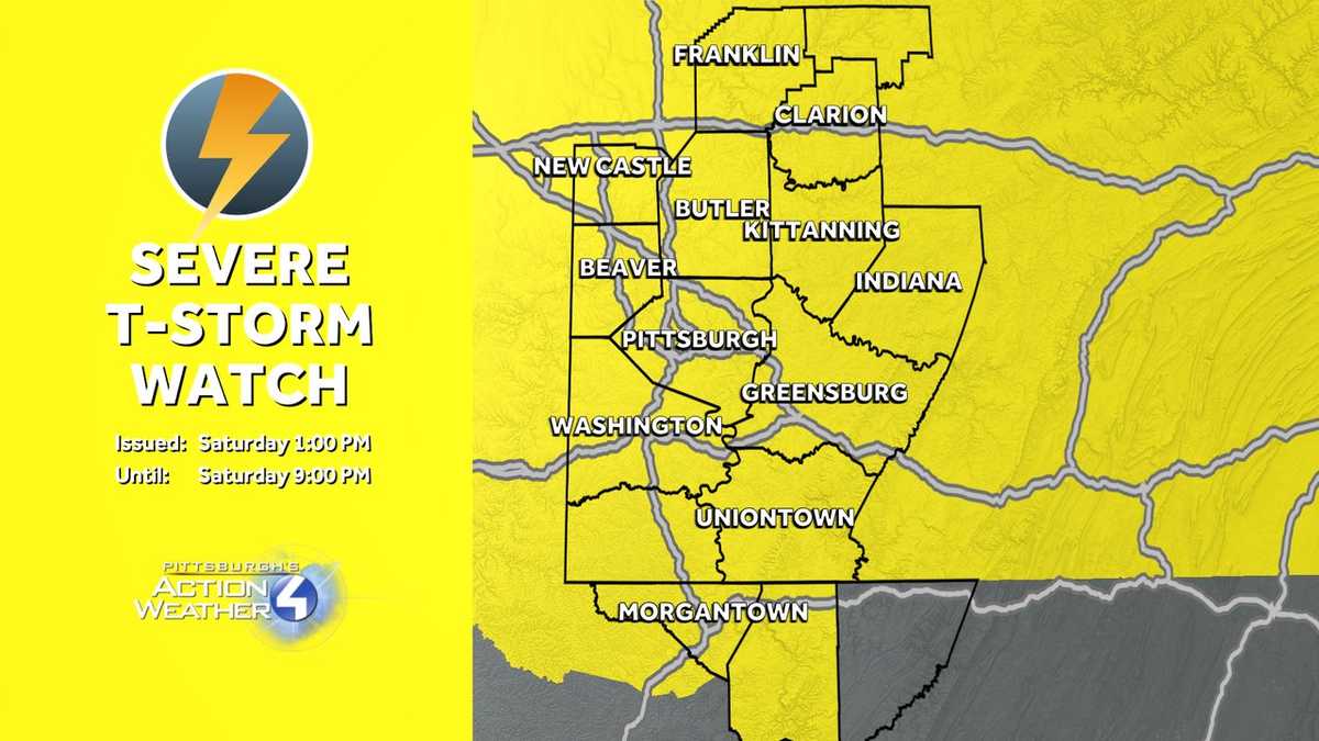
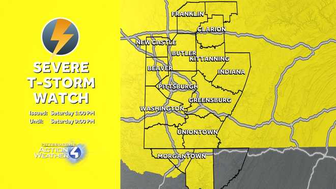
All of Western Pennsylvania remains under a Severe Thunderstorm Watch Saturday.
The National Weather Service says the watch will remain in place until 9 p.m.
More: Get severe weather alerts for your countyInteractive radar: Track storms as they move through your areaLearn how to enable automatic weather alerts on the WTAE appFlash Flood Warning
A Flash Flood Warning has been issued for parts of Western Pennsylvania on Saturday.
Allegheny County is under the warning until 7 p.m., as Westmoreland County remains under the warning until 8:15 p.m.
Some locations that will experience flash flooding include… Monroeville, Murrysville, North Versailles, Wilkins Township, Turtle Creek, Pitcairn, Trafford, Delmont, Wilmerding, East Pittsburgh, Export, Wall and Slickville
Officials urge drivers to turn around if a road appears to be flooded.
Flood Watch
Parts of Western Pennsylvania also remain under a Flood Watch due to expected severe thunderstorms in the area.
Portions of Pennsylvania, including the following areas: Armstrong, Clarion, Fayette, Higher Elevations of Fayette, Higher Elevations of Indiana, Higher Elevations of Westmoreland, Indiana, Jefferson PA, and Westmoreland and northern West Virginia, including the following areas: Eastern Preston and Preston, are under the watch until late Saturday evening.
Severe Weather Alert Day: Late-day strong storms
Hearst OwnedHearst
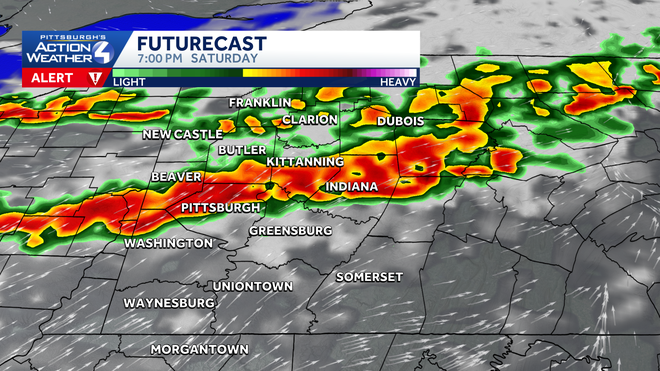
A line of thunderstorms drops south between 4 p.m. and 10 p.m. Some storms could be strong to severe. Downpours are also expected.
Spotty showers will be off and on throughout the day. Rain may be heavy at times, especially in any thunderstorms, with some locations potentially picking up close to inch of rain. We will watch for a severe threat after 4 p.m. through sunset as a line of storms move south. Areas north of Pittsburgh are at a greater risk for severe weather.
Hearst OwnedHearst
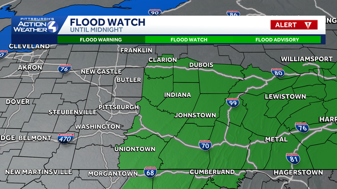
Heavy rain could spark flooding for eastern counties.
A Flood Watch is now in effect until midnight for Armstrong, Clarion, Fayette, Indiana and Westmoreland counties along with Preston and Garrett. Runoff following the late-day heavy rain could lead to flash flooding and rises of creeks and streams.
Hearst OwnedHearst
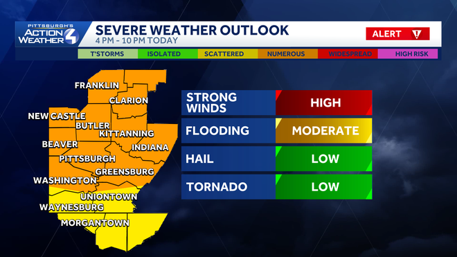
If severe weather develops, damaging winds are the leading threat.
Damaging wind and flooding are the primary concerns. Hail and tornadoes are a lower, but non-zero threat with this line.
Hearst OwnedHearst
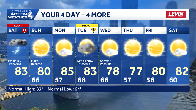
Tuesday is the next day to watch for thunderstorms.