
Iowa weather: Cooler air moves into central Iowa
Intense heat this afternoon will turn to scattered strong storms this evening, some storms could be severe in central and eastern Iowa.
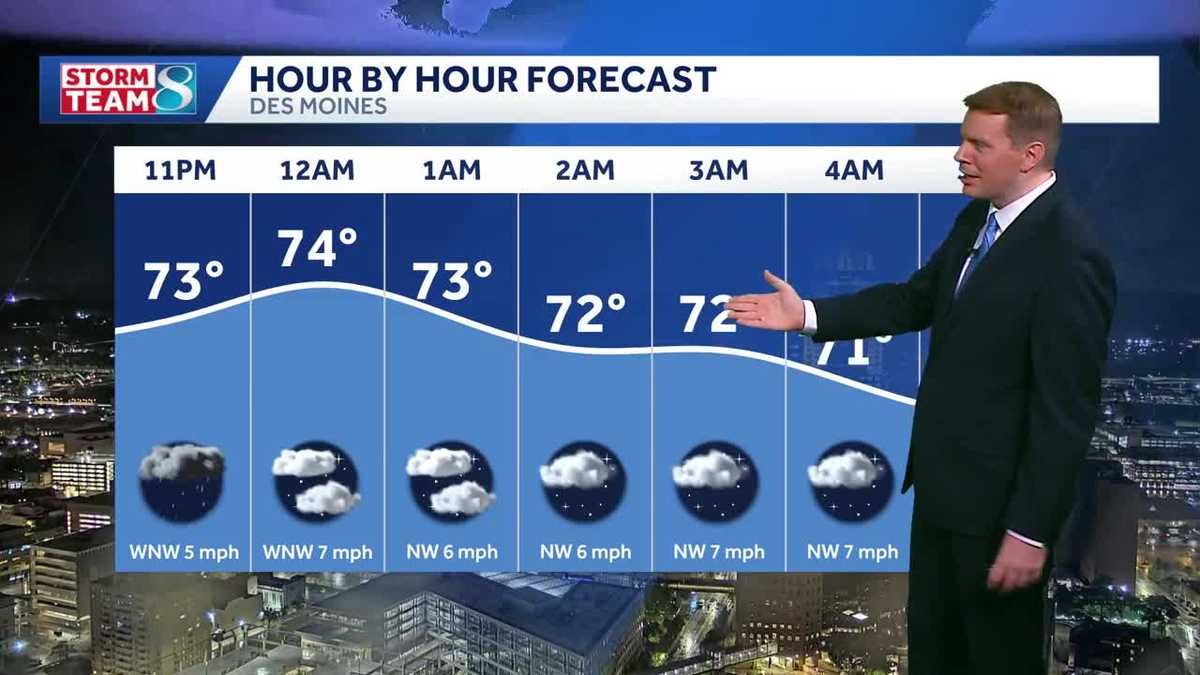
You know, you don’t have to be from Iowa to realize how special Ragry is. Really hot out there today. Yes, the good news is after we had all this, you know, what moved through, at least that will leave behind some cooler temperatures in the next couple of days, getting *** break from the heat thanks to the storms, but hopefully anybody can. Camping out right now is staying dry because there are still some pretty impressive storms out there. Look at all that lightning as we take *** live look here over downtown. Hey, the storms have done one good thing for us here this evening. It’s been, you know, pretty noisy out there. We’ve had some power outages, some hail and wind damage, but at least our temperatures down to 72 degrees. That is *** huge improvement from earlier today when we hit 98 this afternoon here in Des Moines, not *** record. That’ll be 108, but still plenty hot out there. We’ve since dropped to 26 degrees and our current temperature is our low for the day. These storms dropping tremendous rainfall over 3 inches in Ankeny. Just got *** report from Polk City of over 3.5 inches of rain. Ames just over 3.5 inches as well. These are at the airports, the automated rain gauges just shy of 2 inches out at the airport here in Des Moines. We do know there are some areas that have picked. 4.5 to nearly 5 inches of rain, so flooding, isolated flash flooding certainly not out of the question here overnight. But thankfully these storms are dropping down to the south. You can see that slow movement southward, so it is taking the rain out of the metro as we speak. Still raining on the south side of town back into parts of West Des Moines, Joaquie and over toward DeSoto, but all of this activity continues to drop southward. We do still have two severe thunderstorm warnings. One here mostly for Madison into Warren County and another one here for *** storm moving into Apen County. We’ll take *** closer look at that in just *** second. Strongest storm looks to be this just southwest of Redfield. Some heavy rain on I-80 from DeSoto westward, but you come back into town and it looks like the rain is mostly south of I-80. Still some heavy rain here on the south side of West Des Moines. This stretches down to Martinsdale back into Patterson here in eastern Madison County, Western Warren County, getting another really. Deluge of rain, but the rain has ended downtown and as you get up toward Ankeny, the rain has ended. So thankfully we are starting to dry out, especially north of I-80. But all this activity still dropping to the south and east. Here’s that strong storm near Rathman Lake moving into Apenousse County just north of Centerville. This could be producing some hail right over Rathman Lake right now, so we’ll keep an eye on that. That’s probably one of the strongest storms we have in the area currently. And again, all this activity moving south and *** little bit. The east as we head through the next couple of hours. So we’re beginning to see this wind down in the metro, but it will continue across portions of southern Iowa through about midnight. Now because of all that heavy rain we’ve had, flash flood warnings are in place here for most, most of the metro up to Ames through the early morning hours. Here’s some of the rainfall reports in Ankeny, I just got in this report of 3.9 inches of rain, just about 4 inches. You get up into Huxley, 4.7 inches of rain, and we know. Some roads here on the east side of Des Moines are closed due to flooding. So if you see water on the road, turn around. But hey, look at the temperatures 70s around the metro right now, and this cool air continues to spread out across central Iowa, and we will continue to feel those 70s overnight. These storms last for about another hour here in the metro, and then it begins to move on out, but could still have some storms ongoing across southern Iowa through about midnight, maybe 2 o’clock in the morning, but then it moves on south. And we’ll see quieter weather into tomorrow morning. Look at the 60s across the north side of the state, 70s to start off your Tuesday. Tomorrow afternoon, about 83 degrees, not bad, even better on Wednesday with *** high of 79. Really rest of the week looking pretty good out there.
Iowa weather: Cooler air moves into central Iowa
Intense heat this afternoon will turn to scattered strong storms this evening, some storms could be severe in central and eastern Iowa.

Updated: 10:53 PM CDT Jul 20, 2026
Cooler air pushes in behind the front with gusty north winds on Tuesday. Highs only top out in the low to mid-80s, with some 70s possible in northern Iowa. Interactive Radar | Weather Alerts | SkycamsMuch of the area could see highs in the upper 70s on Wednesday. The mild air continues Thursday and Friday with highs near 80.Rain chances are lower through the end of the week, with only a slight chance of showers Thursday into Friday. High pressure builds back in for the weekend with more sunshine and hotter conditions returning.Keep an eye on weather across Iowa with KCCI’s skycamsWeather watchers can keep an eye on conditions by checking our skycam page, which shows aerial views from more than 20 sites across the state.Iowa weather forecast:Today: Generally sunny despite a few afternoon clouds. Isolated pop-up storms possible in the afternoon. Any storm will be very brief. High 93F. Winds SW at 10 to 15 mph.Tonight: Clear skies. Low near 74F. Winds SW at 10 to 15 mph.Tomorrow: Generally sunny despite a few afternoon clouds. High 93F. Winds NW at 5 to 10 mph.Tomorrow Night: A few clouds. Low around 70F. Winds ENE at 5 to 10 mph.
DES MOINES, Iowa —
Cooler air pushes in behind the front with gusty north winds on Tuesday. Highs only top out in the low to mid-80s, with some 70s possible in northern Iowa.
Interactive Radar | Weather Alerts | Skycams
Much of the area could see highs in the upper 70s on Wednesday. The mild air continues Thursday and Friday with highs near 80.
Rain chances are lower through the end of the week, with only a slight chance of showers Thursday into Friday. High pressure builds back in for the weekend with more sunshine and hotter conditions returning.
Keep an eye on weather across Iowa with KCCI’s skycams
Weather watchers can keep an eye on conditions by checking our skycam page, which shows aerial views from more than 20 sites across the state.
2 of 29
Des Moines: Iowa State Fairgrounds
3 of 29
Des Moines: Northeast mixmaster
4 of 29
Des Moines: Principal Park
5 of 29
Algona: Security State Bank
6 of 29
Altoona: Prairie Meadows Casino, Racetrack & Hotel
7 of 29
Ames: Flyover ramp
8 of 29
Ankeny: The District
9 of 29
Arnolds Park Amusement Park: West Lake Okoboji
10 of 29
Downtown Atlantic
11 of 29
Bettendorf: Iowa-Illinois Memorial Bridge
12 of 29
Boone: Scenic Valley Railroad
13 of 29
Boone: Seven Oaks Recreation
15 of 29
Council Bluffs: Bayliss Park
16 of 29
Council Bluffs: Lewis and Clark Monument Park
17 of 29
Creston Greater Regional Health
18 of 29
Indianola: Simpson College
19 of 29
Iowa City: University of Iowa Stanley Hydraulics Laboratory
PHOTO: University of Iowa
20 of 29
Lamoni: Amish Country Store
21 of 29
Malcom: Interstate 80
22 of 29
Marshalltown: Westown Apartments
23 of 29
Newton: DMACC Legacy Plaza
24 of 29
Osceola: Interstate 35/Highway 34 overpass
25 of 29
Panora: Lake Panorama
26 of 29
Pella: The Amsterdam Hotel
27 of 29
Polk City: Big Creek Marina
28 of 29
West Des Moines Public Library
29 of 29
West Des Moines: West mixmaster
Iowa weather forecast:
Today: Generally sunny despite a few afternoon clouds. Isolated pop-up storms possible in the afternoon. Any storm will be very brief. High 93F. Winds SW at 10 to 15 mph.
Tonight: Clear skies. Low near 74F. Winds SW at 10 to 15 mph.
Tomorrow: Generally sunny despite a few afternoon clouds. High 93F. Winds NW at 5 to 10 mph.
Tomorrow Night: A few clouds. Low around 70F. Winds ENE at 5 to 10 mph.
1 of 11
Current Central Iowa temperatures
2 of 11
Central Iowa 8-Day forecast from KCCI 8 News
3 of 11
Live Doppler HD Metro
PHOTO: kcci
4 of 11
Live Doppler HD Statewide Radar
PHOTO: kcci
5 of 11
Live Doppler HD Polk County
PHOTO: kcci
6 of 11
Current statewide temperatures
7 of 11
Current statewide ‘feels like’ temperatures
8 of 11
Live Doppler HD Southwest
PHOTO: kcci
9 of 11
Live Doppler HD Southeast
PHOTO: kcci
10 of 11
Live Doppler HD Northeast
PHOTO: kcci
11 of 11
Live Doppler HD Northwest
PHOTO: kcci