
UPDATE: Evacuations levels increase for Hagan Fire in Umatilla County
Published 5:30 pm Wednesday, July 22, 2026
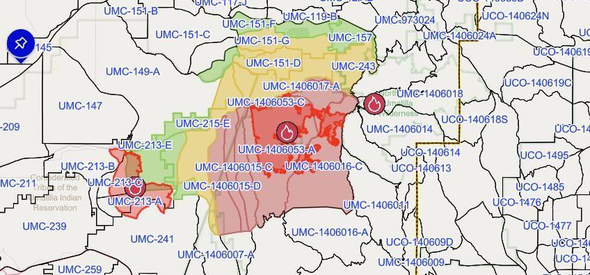
UMATILLA COUNTY — The Umatilla County Sheriff’s Office and Umatilla County Emergency Operation Center in cooperation with the Confederated Tribes of the Umatilla Indian Reservation and Northwest Incident Management Team 7 has increased evacuation levels associated with the Hagen Fire.
According to the update Wednesday afternoon, July 22, the decision to increase the evacuation levels was made after carefully considering the forecast weather conditions, the observed fire behavior, and the heavy fuels and dry timber, which together could create a high-risk environment for rapid fire spread.
“Additionally, given the remote and difficult terrain, we are committed to ensure residents have the maximum time to prepare and leave should a sudden shift in the fire cut off access routes,” according to the update. “We are instructing residents in all these areas to take extra precautions. While every effort is being made to provide timely updates on evacuation levels and fire behavior, local terrain presents significant communication and access challenges.”
Due to the remote nature of these affected areas, residents must remain extremely vigilant and proactively monitor surrounding fire activity. Fire conditions can change rapidly and unpredictably. Do not wait for an official evacuation order if you feel unsafe or see immediate danger.
The following evacuation levels are now in effect:
LEVEL 1 (BE READY)
Evacuation Zones:
UMC-151-I
UMC-151-E
UMC-123-D
UMC-1406020
UMC-215-F
UMC-215-C
UMC-213-D
UMC-213-E
UMC-147-B
LEVEL 1 includes a section west of the intersection of Abel Lane and Wildhorse Road.
An area east of the intersection of McIntyre Road and Forest Service 32, including Langdon Lake. And the area of Bingham Road, west from Iskuulpa Creek to the intersection of Cayuse Road and Kanine Road.
LEVEL 2 (BE SET)
Evacuation Zones:
UMC-151-F
UMC-151-E
UMC-155-A
UMC-157
UMC-215-F
UMC-215-C
UMC-215-B
UMC-213-E
UMC-213-D
UMC-117-I
UMC-117-H
UMC-75-C
UMC-119-B
UMC-123-C
UMC-121-B
UMC-123-B
UMC-121-A
UMC-123-E
UMC-1406056
UMC-215-E
UMC-1406007-B
UMC-149-B
UMC-149-C
UMC-151-G
UMC-151-H
UMC-151-D
UMC-153
UMC-155-B
UMC-215-A
UMC-215-D
UMC-243
LEVEL 2 Area:
The entire area north of Bingham Road from Iskuulpa Creek east to Forest Service Road 32. (although the area between the CTUIR boundary and Meacham Creek Road is LEVEL 3) LEVEL 2 also includes the entire area between Bingham Road and Highway 204 from Blue Mountain Outpost to McIntyre Road. Then the area 4 miles north above Highway 204, paralleling Highway 204 from Lincton Mountain Road, west across Basket Mountain Road over to Ragborn road.
This includes all residential areas north of Bingham Road including north of Highway 204 to include some:
Hodgson Road
Pea Ridge Road
Basket Mountain Road
Lincton Mountain Road 4 miles north of Highway 204
Ragborn Lane
Willow Road
Black Pine Lane
Strawberry Lane
Snowshoe Lane
Willowood Loop
Chalet Lane
Huckleberry Lane
Lower Basket Mountain Road
Giger Lane
Lupine Lane
Brutscher Road
Pine Creek Road
Narkus Lane
The Level 2 evacuation was also expanded today west on Bingham Road between Meacham Creek and Iskuulpa Creek to include Gibbon.
LEVEL 3 – GO NOW!
Evacuation Zones:
UMC-1406015-A
UMC-1406016-B
UMC-1406016-C
UMC-1406017-A
UMC-1406017-B
UMC-1406053-A
UMC-1406053-B
UMC-1406053-C
UMC-1406015-C
UMC-1406015-D
LEVEL 3 evacuation area has expanded west on Bingham Road to Meacham Creek Road. LEVEL 3 includes Bingham Road from Meacham Creek Road to the 32 road, including the Umatilla River Corridor and Hagen Creek.
Residents in LEVEL 3 areas should leave immediately. Imminent danger in the area. Leave without delay. It is unsafe to stay.
Continue to follow official fire updates at Paradise, Hagen and Horse Ridge Fire Information.
The most current Evacuation Levels and information for Umatilla County can be found on our webpage Emergency Advisories.