The Gulf Coast News Hurricane Tracking team continues to monitor the movement of Tropical Storm Erin in the eastern Atlantic Ocean. As of 11 p.m. Tuesday, the system is currently moving west at 20 mph with maximum sustained winds of 45 mph. At last check, the storm was located 1,000 miles west-northwest of the Cabo Verde Islands and 1,520 miles east of the Northern Leeward Islands. Erin will continue on a westerly track across the eastern tropical Atlantic, nearing the Caribbean by the later part of the week. Erin is expected to have slow strengthening in the immediate days ahead with greater strengthening as it approaches a more conducive environment late week. It is expected to intensify as it moves over warmer waters, becoming the first Atlantic hurricane of 2025 by sometime Friday, and then becoming the first major hurricane of 2025 as it tracks north of the Caribbean late this weekend. The term major hurricane includes all storms that are at least category 3 intensity and stronger, whether they impact any areas of land or not. Forecast models remain in decent agreement that the storm will stay north of the Caribbean and turn north prior to reaching the Bahamas. Following a path like this would keep the storm away from the United States. Still, we will continue to track Erin closely and alert you of any changes in that forecast. Stay with the Gulf Coast Storm Team as we continue to monitor Erin for you throughout the week.The NHC is now monitoring a new area in the tropics, closer to home in the Caribbean that would move across the Yucatan and into the Bay of Campeche. Development chances remain low, and any system that does form would track west into Mexico, posing no threat to Florida.The Atlantic hurricane season runs from June 1 through Nov. 30. Follow Gulf Coast News online and on air for Southwest Florida’s Most Accurate weather forecast.Be prepared with the Gulf Coast News 2025 Hurricane GuideLive Interactive RadarCheck out the interactive Gulf Coast Live RadarWatch your Gulf Coast Weather forecasts on TV or onlineHere’s where to find our latest weather forecast videoYou can also watch newscasts live or on demand hereOr download the Gulf Coast News app to stream on your phone or tabletFollow the Gulf Coast Storm Team on social mediaChief Meteorologist Allyson Rae on Facebook and XMeteorologist Caroline Castora on Facebook and XMeteorologist Jim Dickey on Facebook and XMeteorologist Jason Dunning on Facebook and XMeteorologist Rob Duns on Facebook and XMeteorologist Lauren Hope on Facebook and XMeteorologist Raphael Tavernier on Facebook and XDOWNLOAD the free Gulf Coast News app for your latest breaking news and weather alerts. And check out the Very Local Gulf Coast app to stream news, entertainment and original programming on your TV.
FORT MYERS, Fla. —
The Gulf Coast News Hurricane Tracking team continues to monitor the movement of Tropical Storm Erin in the eastern Atlantic Ocean.
As of 11 p.m. Tuesday, the system is currently moving west at 20 mph with maximum sustained winds of 45 mph.
At last check, the storm was located 1,000 miles west-northwest of the Cabo Verde Islands and 1,520 miles east of the Northern Leeward Islands.
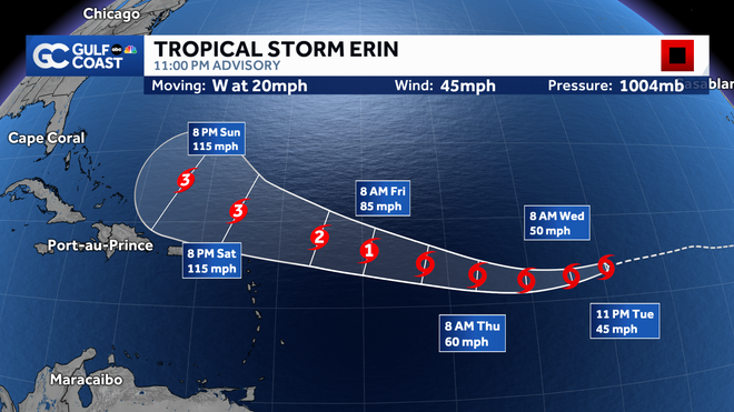
Erin will continue on a westerly track across the eastern tropical Atlantic, nearing the Caribbean by the later part of the week. Erin is expected to have slow strengthening in the immediate days ahead with greater strengthening as it approaches a more conducive environment late week.

Gulf Coast News
Erin Forecast Cone
It is expected to intensify as it moves over warmer waters, becoming the first Atlantic hurricane of 2025 by sometime Friday, and then becoming the first major hurricane of 2025 as it tracks north of the Caribbean late this weekend.
The term major hurricane includes all storms that are at least category 3 intensity and stronger, whether they impact any areas of land or not.
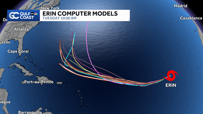
Forecast models remain in decent agreement that the storm will stay north of the Caribbean and turn north prior to reaching the Bahamas. Following a path like this would keep the storm away from the United States.

Gulf Coast News
Erin Computer Models
Still, we will continue to track Erin closely and alert you of any changes in that forecast. Stay with the Gulf Coast Storm Team as we continue to monitor Erin for you throughout the week.
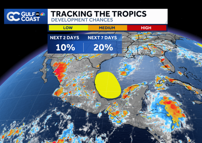
The NHC is now monitoring a new area in the tropics, closer to home in the Caribbean that would move across the Yucatan and into the Bay of Campeche. Development chances remain low, and any system that does form would track west into Mexico, posing no threat to Florida.

Gulf Coast News
Tracking the Tropics
The Atlantic hurricane season runs from June 1 through Nov. 30. Follow Gulf Coast News online and on air for Southwest Florida’s Most Accurate weather forecast.
Live Interactive Radar
Watch your Gulf Coast Weather forecasts on TV or online
Follow the Gulf Coast Storm Team on social media
Chief Meteorologist Allyson Rae on Facebook and XMeteorologist Caroline Castora on Facebook and XMeteorologist Jim Dickey on Facebook and XMeteorologist Jason Dunning on Facebook and XMeteorologist Rob Duns on Facebook and XMeteorologist Lauren Hope on Facebook and XMeteorologist Raphael Tavernier on Facebook and X
DOWNLOAD the free Gulf Coast News app for your latest breaking news and weather alerts. And check out the Very Local Gulf Coast app to stream news, entertainment and original programming on your TV.

