
We have yet another beautiful start to the day in Wytheville and mild temperatures to go along with it! We are still a bit muggy outside, so even the 60s feel a bit warmer. The moisture will fuel showers and storms later on this afternoon.
Temperatures Current as of 6:30A (WSLS 2026)
Here is another look at our setup today: a ridge of high pressure is taking control and bringing all the heat and humidity to the Southeast and Midwest. Here in Southwest and Southside Virginia, we will get in on the above-average temps to close out the workweek as well.
Thursday Setup (WSLS 2026)
Our setup a little closer to home shows a boundary a little further north of us that will oscillate around our area and keep us in the active weather pattern through the weekend. You’ll want to keep the umbrella handy just in case!
Futurecast (WSLS 2026)
All eyes are shifting towards the tropics as well, as sea surface temperatures have increased as the summer has worn on. Our first area of interest highlighted in red will possibly become Tropical Storm Dolly in the coming days, but we will keep a close eye on it!
Tropical Outlook (WSLS 2026)
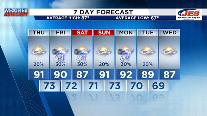
Here, a little closer to home, we have what at first glance looks like a washout ahead, but is really a daily chance of isolated to scattered showers and storms through early next week. Have a great Thursday!
7-Day (WSLS 2026)
Copyright 2026 by WSLS 10 – All rights reserved.