

Patchy fog may be possible waking up on Monday however, the rest of the day is expected to be sunny. Scattered showers and thunderstorms return later Tuesday as well as an isolated chance for severe weather.
COPYRIGHT 2026 BY CHANNEL 3000. ALL RIGHTS RESERVED. THIS MATERIAL MAY NOT BE PUBLISHED, BROADCAST, REWRITTEN OR REDISTRIBUTED.
Download the First Warn Weather app here
WHAT WE’RE TRACKING:
Nice day ahead MondayScattered showers and thunderstorms possible Tuesday, with a low isolated severe chanceTemperatures stay seasonal over the next 10 days

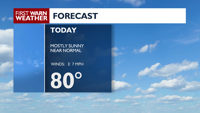
NEXT 24 HOURS: A high-pressure system sticks around overhead Monday, which will keep the humidity low and sky conditions mostly sunny Monday. Temperatures will climb into the lower 80s Monday afternoon. Monday night temperatures stay in the mid 60s with clouds increasing. There is a slight chance of isolated showers and thunderstorms.
COPYRIGHT 2026 BY CHANNEL 3000. ALL RIGHTS RESERVED. THIS MATERIAL MAY NOT BE PUBLISHED, BROADCAST, REWRITTEN OR REDISTRIBUTED.
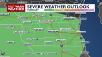
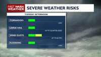
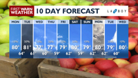
EXTENDED FORECAST: The better chances for showers and thunderstorms will be possible on Tuesday. Across southwestern Wisconsin, there’s an isolated chance for a severe thunderstorm or two with strong wind gusts and large hail as the main threats. Following that system, temperatures will settle into the upper 70s for the rest of the week.
COPYRIGHT 2026 BY CHANNEL 3000. ALL RIGHTS RESERVED. THIS MATERIAL MAY NOT BE PUBLISHED, BROADCAST, REWRITTEN OR REDISTRIBUTED.
Right Now
63°
Partly Cloudy
Humidity: 89%
Feels Like: 63°
Heat Index: 63°
Wind: 1 mph
Wind Chill: 63°
UV Index: 8 Very High
Sunrise: 06:06:14 AM
Sunset: 07:57:09 PM
Dew Point: 60°
Visibility: 10 mi
Today
Mostly sunny and pleasant. Wind: NW 5 MPH.
Tonight
Partly cloudy with a slight chance for showers and thunderstorms. Wind: SW 5-10 MPH.
Tomorrow
Partly sunny with scattered showers and thunderstorms. Wind: SW 10 MPH.
Mon
Monday
80°/64°
More sun than clouds. Highs in the low 80s and lows in the mid 60s.
Monday Night
Partly cloudy with a slight chance for showers and thunderstorms. Wind: SW 5-10 MPH.
Tue
Tuesday
81°/61°
Showers and thunderstorms late. Highs in the upper 70s and lows in the low 60s.
Tuesday Night
Partly cloudy.
Wed
Wednesday
77°/60°
Partly cloudy. Highs in the low 80s and lows in the upper 50s.
Wednesday Night
Partly cloudy.
Thu
Thursday
77°/59°
Mix of sun and clouds. Highs in the low 80s and lows in the low 60s.
Thursday Night
Partly cloudy.
Fri
Friday
79°/62°
Showers and thunderstorms late. Highs in the low 80s and lows in the upper 50s.
Friday Night
Mostly cloudy with a slight chance for showers and thunderstorms.
Sat
Saturday
80°/59°
Mix of sun and clouds. Highs in the mid 70s and lows in the mid 50s.
Saturday Night
Mostly clear.
Sun
Sunday
79°/62°
Mix of sun and clouds. Highs in the mid 70s and lows in the low 50s.
Sunday Night
Partly cloudy.
Mon
Monday
80°/62°
Mostly sunny. Highs in the mid 70s and lows in the mid 50s.
Monday Night
Partly cloudy with a slight chance for showers and thunderstorms.
Tue
Tuesday
79°/60°
Times of sun and clouds. Highs in the upper 70s and lows in the low 60s.
Tuesday Night
Mostly clear.
Wed
Wednesday
80°/63°
Mix of sun and clouds. Highs in the low 80s and lows in the low 60s.
Wednesday Night
Partly cloudy. Low 63F. Winds ENE at 5 to 10 mph.