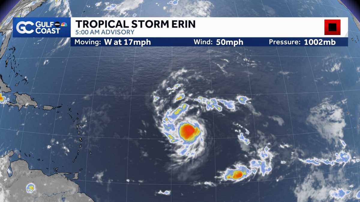
BELIEVE IT WAS MORE THAN 8,000 PEOPLE. >> WHEN YOU TALK ABOUT OUT THERE ACROSS THE TROPICS HERE THIS MORNING, INCLUDING YES, TROPICAL STORM ERIN AT 50 MILE PER HOUR. TROPICAL STORM MOVING TO THE WEST AT 17 MILES PER HOUR RIGHT NOW IS JUST GOT THAT 5 O’CLOCK ADVISORY IN SO HAS NOT REALLY STARTED TO STRENGTHEN JUST YET. BUT THIS IS EXPECTED TO CONTINUE TO INTENSIFY AND A DECENT CLIP AS YOU GO THROUGH THE NEXT COUPLE OF DAYS NOW IT’S HELD SERVE INTENSITY WISE, GOING BACK TO THE LAST COUPLE OF DAYS FOR A NUMBER OF REASONS. ONE BEING ON THE SAHARAN DUST AROUND IT. NOW YOU SEE FOR YOURSELF ON OUR SAHARAN DUST TRACKER, THE HIGHER DENSITY DRY DUSTY AIR IS OFF TO THE EAST OF THIS SORT OF SURROUND ITSELF IN A POCKET OF MOISTURE SORT OF STEP ONE FOR THE STORM TO TRY TO CONTINUE TO INTENSIFY ALONG WITH THAT. IT’S MOVING OVER WARMER WATERS. YOU SEE THE TRACK. IT HAS TAKEN WATER. TEMPERATURES ARE IN THE UPPER 70’S LOW 80’S GOING BACK CLOSE TO THE CABO VERDE ISLANDS. THAT’S BARELY WARM ENOUGH TO SUPPORT A TROPICAL SYSTEM LITTLE AND ALLOW HIM TO STRENGTHEN NOW ITS IN WATER TEMPERATURES. 82 83, 84 AND YOU SEE WHERE IT’S HEADED TOWARDS WHERE THE WATER TEMPERATURES ARE IN THE MID AND UPPER 80’S. SO ALL EXPECTATIONS ARE THIS STORM WILL INTENSIFY AS WE GO FORWARD IN TE. EACH LINE HERE, DIFFERENT MODEL FORECAST. NOW ALL OF THEM SHOW THIS AT LEAST BECOMING A HURRICANE BY EARLY NEXT WEEK. THERE WERE A FEW YESTERDAY THAT HELD ON TO KEEPING THIS A TROPICAL STORM AND MOST OF THOSE PLOTS GO UP TOWARDS CATEGORY 2 CATEGORY 3, EVEN TOWARDS CATEGORY 4 INTENSITY. WHICH IS WHAT THE HURRICANE CENTER IS CALLING FOR 2 YEARS. THE BRD-NEW 5 O’CLOCK UPDATE SHOWING THIS REMAINING A TROPICAL STORM NOW THROUGH EARLY FRIDAY MORNING. BUT BY EARLY SATURDAY MORNING, THIS IS A CATEGORY 2 HURRICANE. SO BECOMING THE FIRST HURRICANE OF 2025. IN THE ATLANTIC AND THEN UP TO CATEGORY 3 STRENGTH PUSHING TOWARDS CATEGORY 4 STRENGTH AS IT BEGINS TO MAKE THAT TURN. NOW THAT WE’RE GETTING CLOSER IN TIME, YOU CAN SEE THAT WELL PRONOUNCED TURN IN THE NHC FORECAST PATH TO STAYS WELL TO THE EAST OF FLORIDA AT THIS TIME, DIRECT IMPACTS NOT EXPECTED IN THE STATE OF FLORIDA FROM AARON. YOU CAN SEE WHY THE STRING IS GOING TO SET UP THE WAY IT IS. HIGH PRESSURE BACKING ALL THE WAY OFF TOWARDS NORTHERN AFRICA THAT ALLOWS THIS TO FIND A WEAKNESS IN THAT STEERING RAGE. AND AGAIN, TURN TO THE NORTH RIGHT THE FRINGES OF THAT HIGH PRESSURE AREA. KEEPING THIS WELL TO THE EAST OF FLORIDA. BUT WHEN YOU LOOK AT THE DIFFERENT MODELS, JUST BUT EACH AND EVERY MODEL YOU LOOK AT SHOWS THAT WELL PRONOUNCED TURN, THIS IS FAIRLY GOOD AGREEMENT IN THE MODELS HERE. NOTHING COMING ANYWHERE CLOSE TO FLORIDA OR THE BAHAMAS AS THAT DOES YES, TURN OFF TO THE NORTH. STILL SOME FRINGE IMPACTS FROM THIS, INCLUDING SOME SERIOUS WAVE HEIGHTS BUILDING WITH THAT MAJOR HURRICANE OFF TO THE EAST OF FLORIDA. WATCH ALL THESE WAVE HEIGHTS BUILDING OUR MODEL HERE. WE’RE TALKING 15, 20 FOOT WAVES NORTH OF THE CARIBBEAN THIS WEEKEND BUILDING ALL THE WAY TO ABOUT 35 FEET OFF TO THE EAST OF FLORIDA, GEORGIA AND SOUTH CAROLINA AND BY THE COAST, DANGEROUS SEAS. 2, WE’RE TALKING ABOUT 10 FOOT WAVES FOR THE NORTHEAST COAST OF FLOR
Tracking Tropical Storm Erin: Storm expected to strengthen Thursday

Updated: 5:20 AM EDT Aug 14, 2025
The Gulf Coast News Hurricane Tracking team continues to monitor the movement of Tropical Storm Erin in the Atlantic Ocean. As of 5 a.m. Thursday, the system is currently moving west at 17 mph with maximum sustained winds of 50 mph. At last check, the storm was located 990 miles east of the Northern Leeward Islands. Hurricane Week: Stories of survival, science, and recovery on the Gulf CoastErin will continue on a westerly track across the eastern tropical Atlantic, nearing the Caribbean by the latter part of the week. Erin is expected to gradually intensify today, reaching hurricane strength by early Friday. The storm is expected to continue to intensify through the weekend, likely becoming the first major hurricane of 2025 as it tracks north of the CaribbeanThe term major hurricane includes all storms that are at least category 3 intensity and stronger, whether they impact any areas of land or not. What The Models SayForecast models remain in decent agreement that the storm will stay north of the Caribbean and turn north prior to reaching the Bahamas. This would allow Florida to avoid any direct impacts from the storm.Erin will produce dangerous seas in the Atlantic however as it parallels the east coast. Our models show wave heights up to 35 feet near the center of the storm, with 10 foot wave heights possible near the east coast of Florida next week.We will continue to track Erin closely and alert you of any changes in the forecast. Other Areas We’re WatchingAlong with Erin, the NHC is monitoring an area of disturbed weather in the southwest Gulf that’s been given the designation of Invest 98L.At the moment, the area of disturbed weather is over Mexico’s Yucatan Peninsula, but given it’s west-northwest movement, it will track over the waters of the southwest Gulf later today. As of 2 a.m. Thursday, NHC development odds are being pegged at 20% in both the two and seven-day outlook.Because the area has now been designated as an invest area, we’ll soon be able to see tropical weather forecast model depictions of the system’s movement in the coming 24 hours. While impacts to Florida are not expected, the storm will spread some heavy rain into Mexico and parts of south Texas this weekendWe’ll keep you updated on Gulf Coast News. Hurricane WeekIsland Park neighbors concerned about flooding, Lee County working on solutionsMatlacha pushes forward as last storm-damaged buildings set for demolitionFort Myers resident installs flood barriers to protect home and car’Each tree and each site is going to be different’: Ways to prepare trees for hurricane seasonIs your home really hurricane-resistant? Inspector shares what to checkManasota Key bounces back from Hurricane Milton, prepares for future stormsParadise shaken, not broken: Manasota Key residents look back on Hurricane Milton’s tollThe Atlantic hurricane season runs from June 1 through Nov. 30. Follow Gulf Coast News online and on air for Southwest Florida’s Most Accurate weather forecast.Be prepared with the Gulf Coast News 2025 Hurricane GuideLive Interactive RadarCheck out the interactive Gulf Coast Live RadarWatch your Gulf Coast Weather forecasts on TV or onlineHere’s where to find our latest weather forecast videoYou can also watch newscasts live or on demand hereOr download the Gulf Coast News app to stream on your phone or tabletFollow the Gulf Coast Storm Team on social mediaChief Meteorologist Allyson Rae on Facebook and XMeteorologist Caroline Castora on Facebook and XMeteorologist Jim Dickey on Facebook and XMeteorologist Jason Dunning on Facebook and XMeteorologist Rob Duns on Facebook and XMeteorologist Lauren Hope on Facebook and XMeteorologist Raphael Tavernier on Facebook and XDOWNLOAD the free Gulf Coast News app for your latest breaking news and weather alerts. And check out the Very Local Gulf Coast app to stream news, entertainment and original programming on your TV.
FORT MYERS, Fla. —
The Gulf Coast News Hurricane Tracking team continues to monitor the movement of Tropical Storm Erin in the Atlantic Ocean.
As of 5 a.m. Thursday, the system is currently moving west at 17 mph with maximum sustained winds of 50 mph.
At last check, the storm was located 990 miles east of the Northern Leeward Islands.
Hurricane Week: Stories of survival, science, and recovery on the Gulf Coast
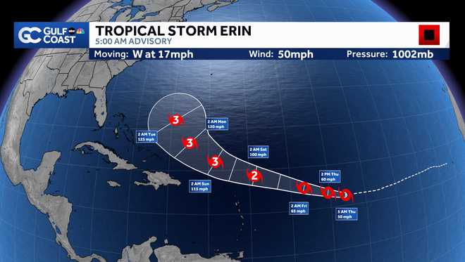
Erin will continue on a westerly track across the eastern tropical Atlantic, nearing the Caribbean by the latter part of the week. Erin is expected to gradually intensify today, reaching hurricane strength by early Friday. The storm is expected to continue to intensify through the weekend, likely becoming the first major hurricane of 2025 as it tracks north of the Caribbean
Gulf Coast News
Tropical Storm Erin 5AM Advisory
The term major hurricane includes all storms that are at least category 3 intensity and stronger, whether they impact any areas of land or not.
What The Models Say
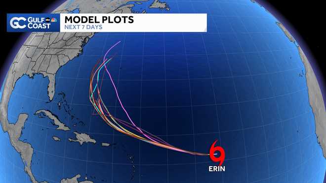
Forecast models remain in decent agreement that the storm will stay north of the Caribbean and turn north prior to reaching the Bahamas. This would allow Florida to avoid any direct impacts from the storm.
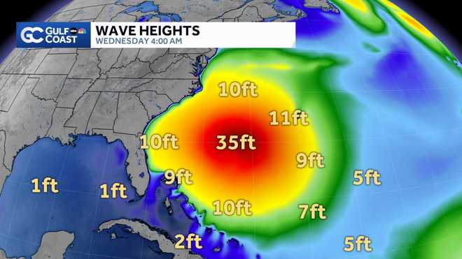
Erin will produce dangerous seas in the Atlantic however as it parallels the east coast. Our models show wave heights up to 35 feet near the center of the storm, with 10 foot wave heights possible near the east coast of Florida next week.
Gulf Coast News
Erin model wave heights
We will continue to track Erin closely and alert you of any changes in the forecast.
Other Areas We’re Watching
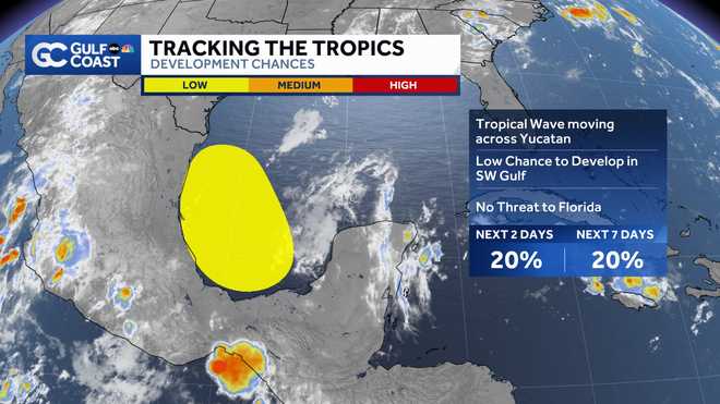
Along with Erin, the NHC is monitoring an area of disturbed weather in the southwest Gulf that’s been given the designation of Invest 98L.
At the moment, the area of disturbed weather is over Mexico’s Yucatan Peninsula, but given it’s west-northwest movement, it will track over the waters of the southwest Gulf later today.
Gulf Coast News
Invest 98L
As of 2 a.m. Thursday, NHC development odds are being pegged at 20% in both the two and seven-day outlook.
Because the area has now been designated as an invest area, we’ll soon be able to see tropical weather forecast model depictions of the system’s movement in the coming 24 hours.
While impacts to Florida are not expected, the storm will spread some heavy rain into Mexico and parts of south Texas this weekend
We’ll keep you updated on Gulf Coast News.
Hurricane Week
The Atlantic hurricane season runs from June 1 through Nov. 30. Follow Gulf Coast News online and on air for Southwest Florida’s Most Accurate weather forecast.
Live Interactive Radar
Watch your Gulf Coast Weather forecasts on TV or online
Follow the Gulf Coast Storm Team on social media
Chief Meteorologist Allyson Rae on Facebook and XMeteorologist Caroline Castora on Facebook and XMeteorologist Jim Dickey on Facebook and XMeteorologist Jason Dunning on Facebook and XMeteorologist Rob Duns on Facebook and XMeteorologist Lauren Hope on Facebook and XMeteorologist Raphael Tavernier on Facebook and X
DOWNLOAD the free Gulf Coast News app for your latest breaking news and weather alerts. And check out the Very Local Gulf Coast app to stream news, entertainment and original programming on your TV.

