BACK INTO THE ROBB WITH THE LATEST ON THE FORECAST WHAT WE TOUCH BASE ON THE ACTUAL HURRICANE THAT’S OUT IN THE ATLANTIC OCEAN. THANKFULLY A LONG DISTANCE AWAY FROM WHERE WE HAPPEN TO BE. >> LATEST ANALYSIS HAS THE CENTER OF HURRICANE ERIN AT 1600 MILES TO THE EAST AND SOUTHEAST OF THE CITY OF CAPE CORAL. BUT AS YOU ARE WELL AWARE, AARON IS NOT COMING TO CAPE CORAL FORECAST CONE AND THANKFULLY THE STEERING CURRENTS, EVANS VERY CONSISTENT OVER THE PAST SEVERAL DAYS. SO THE MOST IMPORTANT STRETCH OF TIME FOR US TO BE FOCUSED ON AIR AND IS BETWEEN LATE SUNDAY AND EARLY MONDAY. THAT’S WHEN THIS GREATLY ANTICIPATED TURN TOWARD THE NORTH. WILL EVENTUALLY HAPPENED. AND I KNOW WE’LL ALL BREEZE A LITTLE EASIER ONES. WE SEE THAT HURRICANE EVENTUALLY MAKE THE TURN. BUT AS I MENTIONED BEFORE, THE STEERING CURRENTS THAT THE THINGS IN THE ATMOSPHERE THAT TELL HURRICANES BASICALLY WHERE TO GO. THOSE HAVE BEEN PRETTY CONSISTENTLY FORECAST AND THAT’S WHY THE FORECAST CONE REALLY HASN’T CHANGED ALL TOO MUCH. AND WHEN YOU LOOK AT SOME OF THE INDIVIDUAL FORECAST MODELS IN TERMS OF THE FOOTPRINT OF HURRICANE ERIN, EVEN THOUGH IT’S GOING TO BE A VERY LARGE STORM. THANKFULLY, WE ARE JUST TOO FAR TO THE WEST TO FEEL ANY DIRECT IMPACTS. THANKFULLY NOW THE EAST COAST, THEY MAY HAVE AN ISSUE WITH RIP CURRENTS BECAUSE OF THIS FEATURE, BUT WE ARE TOO FAR TO THE WEST, WHICH MEANS THERE IS 0 CHANCE OF ANY KIND OF HURRICANE FORCE WINDS NOT ONLY IN OUR AREA, BUT ANY PART OF FLORIDA RIGHT NOW. NOW EVENTUALLY DOWN THE ROAD. PARTS OF THE EAST COAST OF THE UNITED STATES MAY HAVE TO WATCH IT. BUT FROM OUR LOCAL PERSPECTIV
The Gulf Coast Hurricane Tracking team continues to monitor the movement of Hurricane Erin over the Atlantic Ocean. As of 8 p.m. Friday, Erin’s wind strength has increased to 85 mph. The latest pressure was noted at 982 mb and the storm’s forward motion is the same as early on Friday, toward the west-northwest at 17 mph. Hurricane Erin’s center is currently located 310 miles east-northeast of the Northern Leeward Islands. Hurricane Week: Stories of survival, science, and recovery on the Gulf CoastErin will continue on a west-northwest track through the first half of the weekend. As it moves, Erin is expected to continue to gain strength as it tracks north of the Caribbean this weekend. The latest forecast cone from the National Hurricane Center shows Erin reaching major hurricane status north of Puerto Rico on Sunday morning. The term major hurricane includes all storms that are at least category 3 intensity and stronger, whether they impact any areas of land or not. By Monday, the current forecast calls for Erin to become a category 4 hurricane and remain there through Tuesday as it turns northward. What The Models Say Forecast models remain in agreement that the storm will stay north of the Caribbean and turn north prior to reaching the Bahamas. This would allow Florida to avoid any direct impacts from the storm.Erin will produce dangerous seas in the Atlantic, however, as it parallels the east coast of Florida. Our models show wave heights up to 35 feet near the center of the storm, with 10-foot wave heights possible near the east coast of Florida next week.We will continue to track Erin closely and alert you of any changes in the forecast. Other Areas We’re WatchingAlong with Hurricane Erin, we are also monitoring an area of lower pressure off the coast of North Carolina. The National Hurricane Center says this area of disturbed weather has a small window of time this weekend to potentially show some signs of organization, but by early next week, the environment looks hostile for development. Regardless of development, the area of weather will have no impact on Southwest Florida. Hurricane WeekIsland Park neighbors concerned about flooding, Lee County working on solutionsMatlacha pushes forward as last storm-damaged buildings set for demolitionFort Myers resident installs flood barriers to protect home and car’Each tree and each site is going to be different’: Ways to prepare trees for hurricane seasonIs your home really hurricane-resistant? Inspector shares what to checkManasota Key bounces back from Hurricane Milton, prepares for future stormsParadise shaken, not broken: Manasota Key residents look back on Hurricane Milton’s tollThe Atlantic hurricane season runs from June 1 through Nov. 30. Follow Gulf Coast News online and on air for Southwest Florida’s Most Accurate weather forecast.Be prepared with the Gulf Coast News 2025 Hurricane GuideLive Interactive RadarCheck out the interactive Gulf Coast Live RadarWatch your Gulf Coast Weather forecasts on TV or onlineHere’s where to find our latest weather forecast videoYou can also watch newscasts live or on demand hereOr download the Gulf Coast News app to stream on your phone or tabletFollow the Gulf Coast Storm Team on social mediaChief Meteorologist Allyson Rae on Facebook and XMeteorologist Caroline Castora on Facebook and XMeteorologist Jim Dickey on Facebook and XMeteorologist Jason Dunning on Facebook and XMeteorologist Rob Duns on Facebook and XMeteorologist Lauren Hope on Facebook and XMeteorologist Raphael Tavernier on Facebook and XDOWNLOAD the free Gulf Coast News app for your latest breaking news and weather alerts. And check out the Very Local Gulf Coast app to stream news, entertainment and original programming on your TV.
FORT MYERS, Fla. —
The Gulf Coast Hurricane Tracking team continues to monitor the movement of Hurricane Erin over the Atlantic Ocean.
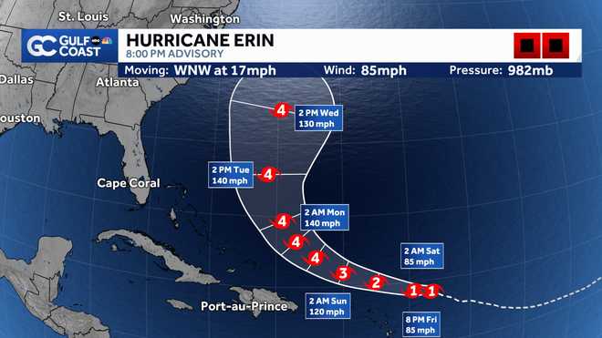
As of 8 p.m. Friday, Erin’s wind strength has increased to 85 mph. The latest pressure was noted at 982 mb and the storm’s forward motion is the same as early on Friday, toward the west-northwest at 17 mph.
Hurricane Erin’s center is currently located 310 miles east-northeast of the Northern Leeward Islands.

Gulf Coast News
Hurricane Erin forecast cone
Hurricane Week: Stories of survival, science, and recovery on the Gulf Coast
Erin will continue on a west-northwest track through the first half of the weekend.
As it moves, Erin is expected to continue to gain strength as it tracks north of the Caribbean this weekend. The latest forecast cone from the National Hurricane Center shows Erin reaching major hurricane status north of Puerto Rico on Sunday morning.
The term major hurricane includes all storms that are at least category 3 intensity and stronger, whether they impact any areas of land or not.
By Monday, the current forecast calls for Erin to become a category 4 hurricane and remain there through Tuesday as it turns northward.
What The Models Say
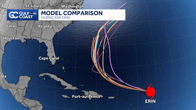
Forecast models remain in agreement that the storm will stay north of the Caribbean and turn north prior to reaching the Bahamas. This would allow Florida to avoid any direct impacts from the storm.

Gulf Coast New
Forecast model comparison
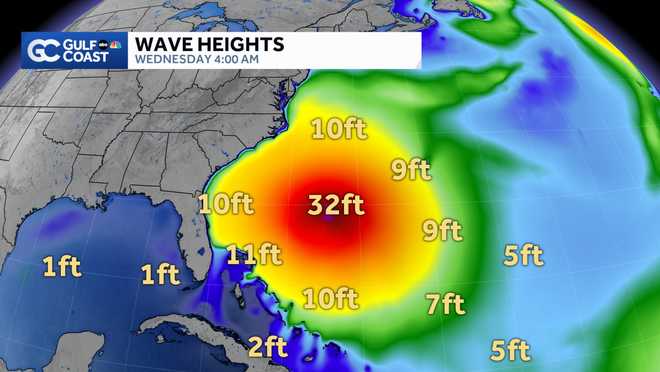
Erin will produce dangerous seas in the Atlantic, however, as it parallels the east coast of Florida. Our models show wave heights up to 35 feet near the center of the storm, with 10-foot wave heights possible near the east coast of Florida next week.

Gulf Coast News
Model Wave Heighs
We will continue to track Erin closely and alert you of any changes in the forecast.
Other Areas We’re Watching
Along with Hurricane Erin, we are also monitoring an area of lower pressure off the coast of North Carolina.
The National Hurricane Center says this area of disturbed weather has a small window of time this weekend to potentially show some signs of organization, but by early next week, the environment looks hostile for development.
Regardless of development, the area of weather will have no impact on Southwest Florida.
Hurricane Week
The Atlantic hurricane season runs from June 1 through Nov. 30. Follow Gulf Coast News online and on air for Southwest Florida’s Most Accurate weather forecast.
Live Interactive Radar
Watch your Gulf Coast Weather forecasts on TV or online
Follow the Gulf Coast Storm Team on social media
Chief Meteorologist Allyson Rae on Facebook and XMeteorologist Caroline Castora on Facebook and XMeteorologist Jim Dickey on Facebook and XMeteorologist Jason Dunning on Facebook and XMeteorologist Rob Duns on Facebook and XMeteorologist Lauren Hope on Facebook and XMeteorologist Raphael Tavernier on Facebook and X
DOWNLOAD the free Gulf Coast News app for your latest breaking news and weather alerts. And check out the Very Local Gulf Coast app to stream news, entertainment and original programming on your TV.

