
NYLCV priority – Citywide Greenway Plan: Implement Local Law 115 of 2022, requiring the Department of Transportation and Parks and Recreation to create a citywide greenway master plan.
“Greenways in New York City date back more than a century, to the nation’s first separated bicycle and pedestrian path constructed in 1894 along Ocean Parkway,” according to the NYCDOT website.
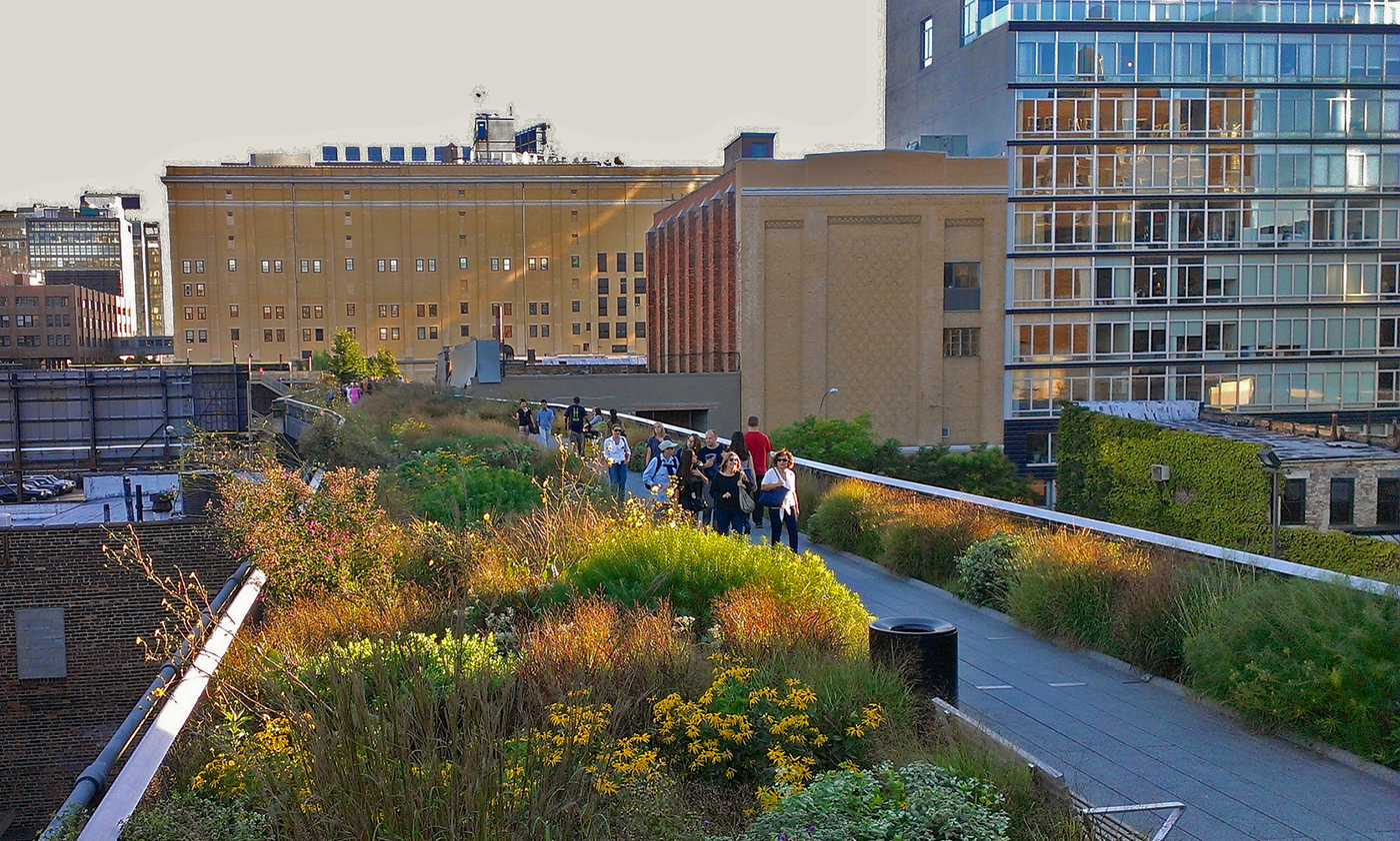
On August 13, New York City announced the release of Greater Greenways: The New York City Greenway Plan, a milestone achievement and a top New York League of Conservation Voters priority. Required under Local Law 115 of 2022, which NYLCV strongly supported, the plan is the city’s first comprehensive greenway vision in more than 30 years.
The plan lays out a detailed roadmap to transform New York’s patchwork of disconnected bikeways and pedestrian paths into a unified, citywide network—bringing safer, healthier, and more sustainable transportation and open space to communities across the five boroughs.
“We are thrilled to see New York City take this major step forward with the release of the Greenway Master Plan,” Said Aila Soomro, Deputy Director for NYC Policy for the New York League of Conservation Voters. “Transforming our city’s patchwork of greenways into a unified, citywide network will make New York more equitable, sustainable, and connected – especially for historically underserved communities that need and deserve better access to open space and clean transportation.”
In 1993, the Greenway Plan for New York City laid out a vision for landscaped paths connecting neighborhoods to open space and waterfronts. As NYCDOT notes, “Greenways offer New Yorkers a peaceful break from their busy lives and an opportunity to enjoy landscaped, continuous paths within City limits. These linear parks expand open spaces into neighborhoods. DOT works to build greenways on City streets and collaborates with other City agencies to elevate the quality of greenways in New York City.”
Today, New York City boasts over 500 miles of greenways with a patchwork of bikeways, pedestrian paths, and trails, which are detailed in the new master plan developed by the NYC Department of Transportation (DOT) and the Department of Parks and Recreation (NYC Parks).
But each greenway segment has been individually operated and maintained by separate organizations or jurisdictions. They rarely connect. Older segments require upgrades, and new network parts are too few and far between.
The master plan aims to connect these disparate, isolated greenways into a citywide open space and transportation network that will be essential infrastructure for an equitable and sustainable future.
With the passage of Local Law 115 in 2022, the City initiated a master plan development process to create a unified city-wide greenway network prioritizing neighborhoods historically underserved by connected open space. New York City also received a $7.25 million federal RAISE grant to plan a significant expansion of the city’s greenway network, focusing on managing and improving cyclist and pedestrian safety.
The RAISE grant was intended to plug gaps in some existing paths, including 16 miles in the Queens Waterfront route, 12 miles from Coney Island to Highland Park along the Historic Brooklyn Greenway, 10 miles from Goethals Bridge to the Verrazano-Narrows Bridge in Staten Island, 15 miles in the South Bronx to SUNY Maritime College from Randall’s Island and seven miles from Spring Creek Park to Brookville Park in South Queens. New York City has committed more than $1.3B to quality open space that integrates the Greenway into Inwood, North Harlem, East Harlem, East Midtown, and Lower East Side.
The new plan also maps more than 100 planned and ongoing greenway capital projects and identifies specific gaps in the network – particularly in the Bronx and Queens – where new corridors will extend greenway access to historically underserved neighborhoods.
Some of the projects that are underway include:
The completion of the Washington Bridge Roadway Redesign means that pedestrians, drivers, bus riders, and cyclists can now cross the Washington Bridge between Manhattan and the Bronx more safely and efficiently.
In the Bronx, New York City is currently undertaking a community-based process to develop a plan for closing the gaps in the Harlem River Waterfront Greenway. The Harlem River Greenway will be a continuous 7-mile transportation corridor connecting Van Cortlandt Park to Randall’s Island. Governor Hochul recently announced $43 million in funding for Harlem River Greenway and climate resiliency.
In Queens, New York City is initiating a community-based process to develop a plan for closing the gaps in current bike and pedestrian infrastructure to make it easier for residents to access parkland and waterways. This new portion of the Queens Waterfront Greenway will constitute a continuous 16-mile corridor connecting Gantry Plaza State Park to Astoria Park along the East River and to Fort Totten following the Long Island Sound.
The Brooklyn Waterfront Greenway is a planned 14-mile pedestrian and bicycle route connecting communities along Brooklyn’s waterfront. Separate paths for bicycles and pedestrians will allow cyclists and walkers to commute, exercise, explore, and relax from Newtown Creek in north Brooklyn to the beginning of the Shore Parkway Greenway in Bay Ridge, creating a 27-mile greenway along Brooklyn’s waterfront.
The Jamaica Bay Greenway is a planned 28-mile network of pedestrian and bicycle paths connecting communities along the Jamaica Bay waterfront to more than 10,000 acres of city, state, and federal parkland, including Rockaway Beach, Marine Park, Canarsie Pier, Floyd Bennett Field, and the Jamaica Bay Wildlife Refuge.
The Manhattan Waterfront Greenway is a vital open space resource for the city, integrating larger parks within a connected network, and providing a bike path for recreation and commuting. The greenway offers residents in some of Manhattan’s most densely populated neighborhoods improved access to the city’s waterfront. When complete, the 32.5-mile Greenway loop will connect a network of green spaces totaling more than 1,000 acres—a space larger than Central Park—running continuously around the island. Joggers, walkers, cyclists, and people of varying ages and abilities from every neighborhood should have access to the Greenway, which is designed within the context of each unique neighborhood.
In addition to developing physical connections, a unified citywide Greenway will be beneficial for New Yorkers in several ways, including by:
Creating more livable and desirable communities by offering residents a place to relax, exercise, and connect with nature.
Providing a space for people to gather, socialize, and connect, fostering a sense of community.
Connecting residents to parks and other open spaces, providing opportunities for recreation and enjoyment of nature.
Mitigating the impacts of climate change by absorbing stormwater to reduce localized flooding and increasing tree cover to lessen the urban heat island effect.
Combating climate change by encouraging people to transition from car travel to walking and cycling, thereby reducing carbon emissions.
Greenways can have a tremendous impact on our health and – not unrelated – our wallets. Studies have found that building bike/pedestrian trails reduces health care costs associated with physical inactivity. Nearly $3 in medical cost savings may be achieved for every dollar invested in building these trails. And an analysis of 10 studies found significant long-term and short-term improvements in self-esteem and mood after individuals exercised in the presence of nature.
Historically, New York City has been a leader in urban greenways. The release of the Greenway Master Plan is a critical step toward realizing the vision of a connected, equitable, and resilient network. It is not just a blueprint for infrastructure, it is an investment in public health, environmental justice, and quality of life for all New Yorkers.
—————————
The New York League of Conservation Voters’ policy objectives address protecting our environment, tackling the climate crisis, and safeguarding public health. NYLCV develops policy agendas that lay out specific legislative and budgetary remedies tailored to different levels of government and regions of the state. They serve as practical blueprints to help guide elected officials, policymakers, political candidates, voters, and the general public toward a more sustainable future. Although policy agendas are developed and promoted to improve people’s well-being and health, the ins and outs of the policy advocacy process can obscure this ultimate objective.
In this series, Policy Means People, the New York League of Conservation Voters’ policy agenda will be described in terms of/ the human outcomes that will follow the successful implementation of policy recommendations. We aim to trace the links between policy objectives and the lived experiences of people affected by that policy. Policies have in common that the proposed action will result in a beneficial outcome, but the mechanism(s) whereby this can occur are often left unspecified.