
UPDATE: 5:15 p.m.
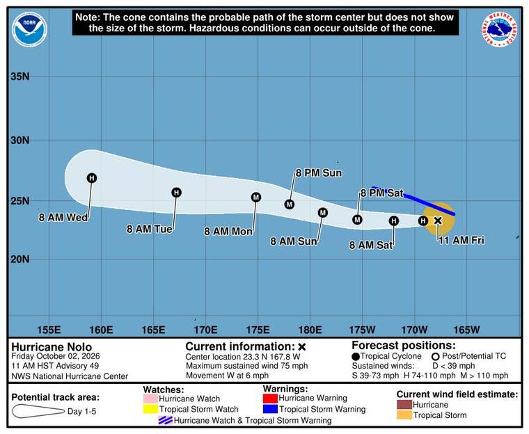
Hurricane Nolo was strengthening over the waters of Papahanaumokuakea Marine National Monument today as it continues to move farther west of the main Hawaiian islands.
As of 5 p.m., Nolo had 85 mph maximum sustained winds and was centered 145 miles west-southwest of French Frigate Shoals, moving west at 7 mph, according to the Central Pacific Hurricane Center. Hurricane-force winds extend up to 25 miles from the center while tropical storm-force winds extend up to 115 miles.
A tropical storm warning is in effect for the national monument from French Frigate Shoals to Lisianski Island, including Maro Reef. The warning means that tropical storm conditions are expected in the area within the next 36 hours.
“A mainly westward motion with an increase in forward speed is expected during the next few days,” forecasters said. “On the forecast track, the center of Nolo will continue to move through the Papahanaumokuakea Marine National Monument but remain just south of the Northwestern Hawaiian Islands west of French Frigate Shoals.”
Nolo, which threatened the state last week, is expected to strengthen back into a major hurricane, peaking with 130 mph sustained winds Sunday, as it moves over the open ocean toward the West Pacific, according to CPHC.
Don’t miss out on what’s happening!
Stay in touch with breaking news, as it happens, conveniently in your email inbox. It’s FREE!
11 a.m.
Nolo has regained hurricane strength as it tracks westward through the Papahanaumokuakea Marine National Monument, and forecasters warn rapid intensification over the next day could turn it into a major hurricane by Saturday.
As of 11 a.m., Hurricane Nolo was centered about 105 miles west-southwest of French Frigate Shoals and 220 miles southeast of Maro Reef, with maximum sustained winds of 75 mph, according to the Central Pacific Hurricane Center. The storm was moving west at 6 mph, but a high-pressure ridge building to its north is expected to accelerate its forward speed threefold by late Saturday.
With wind shear decreasing and ocean temperatures remaining warm, forecasters report a greater than 50% probability of rapid intensification over the next 24 hours. On its forecast track, Nolo will remain south of the Northwestern Hawaiian Islands before crossing the International Date Line this weekend.
A tropical storm warning remains in effect from French Frigate Shoals to Lisianski Island, including Maro Reef, while warnings east of French Frigate Shoals have been discontinued. Tropical storm conditions and large waves will continue to affect the monument through Saturday, with surf expected to inundate low-lying atolls.
No weather watches or warnings are in effect for the main Hawaiian Islands. Trailing moisture continues to bring passing showers to Kauai County today, but drier, tradewind conditions will take hold across the state over the weekend as Nolo moves farther west.
EARLIER COVERAGE
Tropical Storm Nolo strengthened overnight and was nearing hurricane strength again today as it continued moving through the Papahanaumokuakea Marine National Monument, prompting an expanded tropical storm warning covering the entire chain of islands and atolls from Nihoa to Lisianski Island.
As of 5 a.m., Nolo was centered about 75 miles southwest of French Frigate Shoals and 255 miles southeast of Maro Reef, packing maximum sustained winds of 70 mph, up from 60 mph Thursday evening, according to the Central Pacific Hurricane Center. The storm was moving west-northwest at 6 mph. Tropical storm-force winds extend outward up to 115 miles from Nolo’s center.
Forecasters said Nolo is expected to become a hurricane later today and a major hurricane by early Sunday, with additional strengthening likely as the storm’s structure continues to organize.
Nolo is forecast to turn west or west-northwest with an increase in forward speed over the next few days, keeping its center just south of the Northwestern Hawaiian Islands as it tracks through the monument before crossing the International Date Line this weekend.
A tropical storm warning is now in effect for the entire Papahanaumokuakea Marine National Monument from Nihoa to Lisianski Island, including French Frigate Shoals and Maro Reef, the CPHC said. A tropical storm warning means tropical storm conditions are expected somewhere within the warning area within the next 36 hours.
Forecasters said additional watches and warnings may be required for portions of the monument during the weekend as Nolo continues to intensify.
Tropical storm conditions are expected within the warning area from Nihoa to Maro Reef through early Saturday, then farther west from Maro Reef to Lisianski Island by Saturday.
Large surf associated with Nolo will continue to affect the monument over the next several days, forecasters said, warning that the waves will likely inundate some of the low-lying atolls, first from French Frigate Shoals to Maro Reef into the weekend, then from Maro Reef to Lisianski Island during the weekend.
No weather watches or warnings are in effect for the main Hawaiian Islands or their surrounding waters, according to the National Weather Service in Honolulu. Nolo remained too far away to have a direct impact, but forecasters said the storm’s position would keep pulling up moisture from the south, maintaining a wetter pattern through the weekend before a subtropical ridge builds back over the islands and drier conditions return.
Southerly winds across Kauai County and Oahu brought bands of moderate to heavy showers overnight, and brief passing showers are expected to favor windward and mauka areas this morning. Showers and cloud cover are expected to decrease through the weekend as high pressure strengthens and easterly tradewinds fill back in, forecasters said, though increasing clouds and shower activity could return Monday night into Thursday as another disturbance approaches.
Winds across Hawaii’s ocean waters are expected to remain light as Nolo accelerates away from the islands today, diminishing its influence. Gentle east to northeast tradewinds are forecast to return this weekend into early next week, and forecasters said a small craft advisory may be needed for the state’s typically windy channels late in the weekend as those trades strengthen. By midweek, forecasters said, a developing weather pattern northwest of the islands could weaken the trades again and shift them back out of the southeast.
Surf conditions will vary by shore. A moderate swell linked to Nolo will continue to affect Kauai County today before fading tonight, while a small background south swell is expected to hold surf mostly steady elsewhere through the weekend.
A new, longer-period south swell generated by gale-force winds near New Zealand earlier this week is forecast to arrive Sunday and peak Monday through Wednesday. North-facing shores will see a small bump today from a short-period swell, with additional small surf expected early next week. East-facing shores will become slightly choppier as tradewinds build back in over the weekend.
For Kauai, Oahu, Maui, Molokai and Lanai, today will be mostly sunny with scattered showers on Kauai and Oahu and isolated showers across Maui County. Highs will range from 84 to 89 degrees, with east winds around 15 mph.
The Big Island can expect a mostly sunny day with isolated showers. Highs will range from 83 to 88 degrees, with east winds around 15 mph.