
Update: Flood Advisories and Warnings due to today’s rain have expired. A Flood Warning continues along the St. Marys River through Sunday morning as minor flooding continues.
A Coastal Flood Advisory will continue through Thursday morning due to flooding at times of high tide along area waterways.
Rounds of rain soaked southeast Georgia this weekend and there is more to come this week. Scattered showers with thunderstorms, some locally heavy, will linger through early evening. Areas of rain and with isolated thunderstorms will be possible overnight.
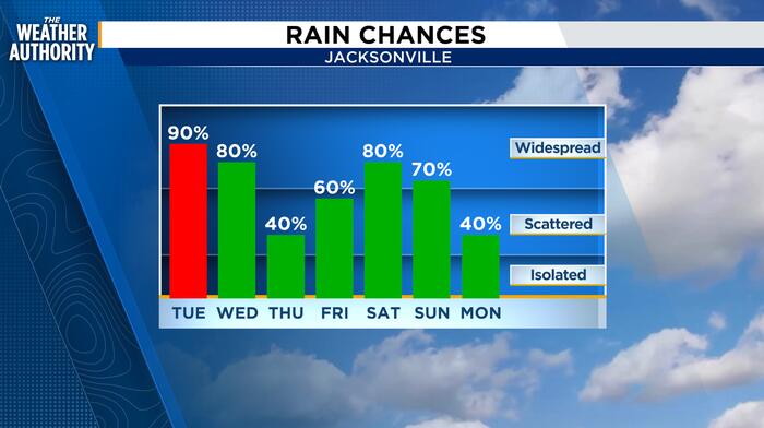
The northeast wind will increase to 15-20 mph with rounds of rain and thunderstorms expected through the day on Tuesday. Locally heavy rain and training of storms will be possible along our coastal counties, including Clay and Putnam counties.
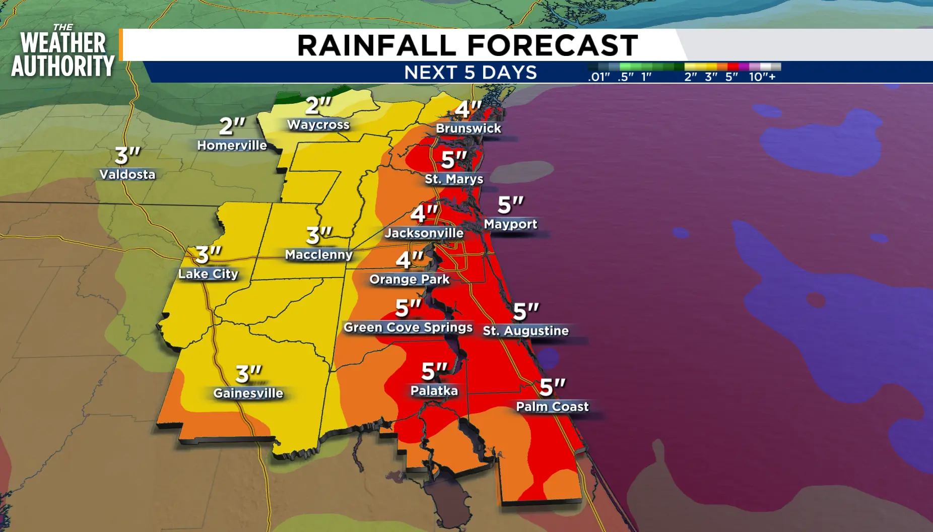
Rainfall averages over the next five days ranges between 2.0 to 5.0 inches with higher amounts possible. The increasing rounds of rain could lead to Flood Advisories while the increasing onshore winds prompt Tidal Flooding along the beaches, Intracoastal and the area rivers.
 . (.)
. (.)
The nor’easter and high astronomical tides will result in minor and potentially moderate coastal flooding during times of high tide along the Atlantic coast, beginning with the late evening high tide on Tuesday and likely continuing through Thursday during each high tide. Minor to moderate
flooding may also become possible within the St. Johns River basin from Wednesday morning through the weekend around times of high tide.
Additionally, coastal impacts including Rip Currents, rough surf and beach erosion, will be likely.
Tonight: Rounds of rain, some locally heavy with isolated thunderstorms. Cloudy skies with showers possible overnight.
Tuesday: Rounds of rain continue as the northeast wind increases through the day. Widespread rain and thunderstorms chances, 80-100 percent. Wind: NE 10 – 15 mph, increasing to 15 – 20 mph. Lows in the 60s and 70s. Highs in the 70s to low 80s. Rain with thunderstorms will be possible overnight.
Wednesday – Friday: Cloudy skies with scattered showers and thunderstorms. Windy and wet on Wednesday with a slight lull in the rain on Thursday. Scattered showers with storms will develop on Friday.
Looking ahead: The unsettled pattern continues this weekend as the northeast winds will turn southerly on Sunday.
Tropics: We are watching a developing spot in the western Gulf. Potential development later this week.
Sunrise: 7:23 a.m.
Sunset: 7:06 p.m.
Copyright 2026 by WJXT News4JAX – All rights reserved.