
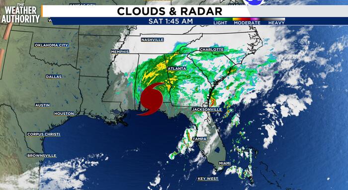
Hurricane Isaias made landfall last night along the Florida Panhandle as a strong Category 2 hurricane, bringing damaging winds, storm surge, flooding rain and tornado concerns to parts of the Gulf Coast.
While the center of the storm moved well west of Northeast Florida and Southeast Georgia, the local impacts are still being felt through tropical moisture, gusty winds, coastal flooding, river flooding, dangerous surf and pockets of heavy rain.
As of early this morning, Isaias had weakened to a post-tropical cyclone after moving inland, but the circulation continues to pull deep tropical moisture across the Southeast.
For Northeast Florida and Southeast Georgia, that means the main threats are not from the core of the hurricane, but from the outer rain bands and the pressure gradient around the storm.
The NWS says persistent showers and scattered thunderstorms will continue through today for some areas. Some storms may become strong to severe, with the potential for damaging wind gusts and a brief tornado.
The highest tornado risk will be across the Suwannee Valley and inland Southeast Georgia THIS AFTERNOON, but the entire area should stay weather-aware.
A Flood Watch remains in effect for much of Northeast Florida and portions of Southeast Georgia. Rainfall totals of 1 to 3 inches are possible, with locally higher amounts where storms train over the same locations.
Because the ground is already saturated from recent rainfall, it will not take much additional rain to create flooding in poor drainage areas, low-lying roads, neighborhoods and near small creeks and streams.
Flooding has already been an issue in parts of the area. The NWS issued flood-related warnings and advisories overnight for portions of Duval, Clay, Nassau, St. Johns and Camden counties, where radar estimated several inches of rain had already fallen in spots.
Additional rainfall could worsen ongoing flooding or lead to new areas of standing water.
Coastal and tidal flooding also remain concerns. Onshore winds, high astronomical tides and elevated water levels will continue to create minor coastal flooding along the beaches, Intracoastal Waterway and parts of the St. Johns River basin.
Coastal Flood Advisories remain in effect for some areas through the weekend, including portions of Jacksonville’s tidal waterways. Around times of high tide, water may cover normally dry roads, lots, parks and other low-lying areas.
The beaches will stay hazardous as well. Rough surf, strong rip currents and elevated water levels will make entering the ocean dangerous.
A High Surf Advisory and Rip Current Statement remain in place for parts of the coast. Even though the hurricane’s center is well inland and west of the region, the Atlantic side is still dealing with the indirect effects of the storm-enhanced onshore flow.
Wind will be another factor today. Wind Advisories are in effect where gusts may be strong enough to bring down small limbs or make driving difficult, especially on bridges and elevated roads. Gusts will be strongest in heavier showers and thunderstorms.
The setup is being driven by several ingredients coming together at once: deep tropical moisture, a lifting warm front, saturated soils, persistent onshore flow and the outer influence of Isaias as it tracks inland. That combination supports periods of heavy rain, isolated severe storms, elevated tides and dangerous marine conditions.
Conditions should gradually improve late tonight into Sunday as Isaias continues to pull farther away and the local pressure gradient relaxes. Rain chances will not disappear immediately, but the coverage should become more scattered by Sunday. Early next week looks quieter, with lower rain chances, more sunshine and a less humid feel.
Copyright 2026 by WJXT News4JAX – All rights reserved.