Hurricane Erin now a Category 5 storm, likely bringing impacts to East Coast next week
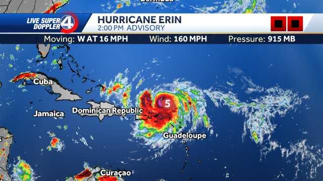
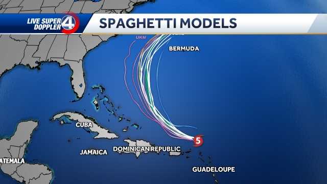
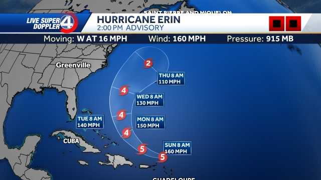
HAPPY SATURDAY! METEOROLOGIST VICTORIA KOKINOS HERE, BRINGING YOU THE LATEST UPDATE ON HURRICANE ERIN. WE JUST HAD THE 8 A.M. UPDATE COME OUT. IT IS STILL A CATEGORY FOUR STORM. THIS IS A STRONG MAJOR HURRICANE. THE FIRST ONE OF THE ENTIRE SEASON. WE TYPICALLY DON’T SEE MAJOR HURRICANES UNTIL SEPTEMBER, SO THIS IS PRETTY EARLY WINDS DURING THE 550 UPDATE, WHICH WAS A SPECIAL UPDATE FROM THE NATIONAL HURRICANE CENTER, WAS THAT 130MPH WINDS ARE NOW UP T 145MPH. IT CAME UP 15 IN JUST AN HOUR OR SO, SO THIS WILL CONTINUE TO MOVE OFF TOWARDS THE WEST NORTHWEST AT 20MPH. THIS IS A VERY STRONG HURRICANE AS IT MOVES OVER THESE WARM ATLANTIC WATERS. IT WILL CONTINUE TO STRENGTHEN OVER THE NEXT COUPLE OF DAYS. NOW IT IS EXPECTED TO HAVE WINDS UP TO 150MPH BEFORE IT STARTS TO RECURVE TOWARDS THE NORTH. HOWEVER, IF THIS CONTINUES TO INCREASE AT THE PACE THAT IT IS, I WOULDN’T BE SURPRISED IF WE DO SEE A CATEGORY FIVE NOW. ONCE IT DOES BEGIN TO RECURVE, IT IS GOING OVER COOLER WATERS OFF THE EAST COAST AND IT WILL BEGIN TO CURVE. AND THAT KIND OF WEAKENS HURRICANES. SO IT IS EXPECTED TO DOWNGRADE NEAR BERMUDA TOWARDS A CATEGORY TWO STORM WITH WINDS DOWN TO ABOUT 110 MILES AN HOUR. NOW NOTICE HOW FAR OFF OF THE EAST COAST THAT IT IS. WE ARE NOT EXPECTING ANY DIRECT IMPACTS FOR NOW, WHICH IS GOOD NEWS. MODELS ARE NOW IN AGREEMENT THAT THIS WILL RECURVE OUT TO SEA. HOWEVER, ANY SHIFT TO THE WEST, THIS WILL DEFINITELY BRING GREATER IMPACT TO PORTIONS OF NORTH CAROLINA AND COASTAL SOUTH CAROLINA RIGHT NOW. IMPACTS THE COASTAL AREAS. IF YOU HAPPEN MAYBE TO GO INTO FOLLY BEACH, TYBEE ISLAND, HILTON HEAD IN THE NEXT COUPLE DAYS, WE WILL DEFINITELY HAVE A HIGH RISK FOR STRONG RIP CURRENTS OVER THE NEXT ABOUT WEEK UNTIL THIS MOVES OUT OF THE AREA. ALSO, THIS WILL BRING WAVE HEIGHTS OF 40FT OR HIGHER TOWARDS THE COAST. THIS IS A PRETTY WIDE STORM THAT IS MOVING NOW. AGAIN, THIS IS BY THURSDAY AT 2 A.M. IT WILL EVENTUALLY MOVE OUT TO SEA. AND OF COURSE WE ARE CONTINUING TO TRACK IT. BUT AGAIN, MODELS ARE NOW, ESPECIALLY WITH OUR SPAGHETTI MODELS ARE IN A BETTER AGREEMENT THAT THIS WILL STAY A GOOD WAYS AWAY FROM THE US COAST, WHICH IS WHAT WE WANT TO SEE. WE’RE NOT EXPECTING ANY DIRECT IMPACTS HERE IN THE UPSTATE OR WESTERN NORTH CAROLINA. LOCALLY HERE, WEATHER WILL CONTINUE TO WARM UP THIS AFTERNOON, HEADING NEAR ABOUT 90 DEGREES FEEL-LIKE. TEMPERATURES NEAR 98. ANY OUTDOOR PLANS FOR YOUR SATURDAY? STAY HYDRATED, WEAR SUNSCREEN. POP UP SHOWERS AND STORMS ARE BACK. IT’S JUST SUMMERTIME STORMS, AND THAT’S SIMILAR FOR THE MOUNTAINS. IF YOU ARE HEADING OUT TO HIKE, MAYBE THIS AFTERNOON. 40% CHANCE OF STORMS BY ABOUT 2:00 FEEL-LIKE. TEMPERATURES IN THE MOUNTAINS WILL BE IN THE UPPER 80S, AND THEN BY EIGHT WERE CLOUDY AND AT 77. OVER THE NEXT COUPLE OF DAYS, WE’LL CONTINUE TO SEE TEMPERATURES WARM UP. WE ARE ACTUALLY SEEING WELL ABOVE AVERAGE FOR THIS TIME OF THE YEAR. SUNDAY, MONDAY AND TUESDAY LOOK NICE AND DRY, WHICH IS GOOD NEWS. BUT THEN BY WEDNESDAY WE’LL SEE POP UP SHOWERS AND STORMS RETURN ALONG OUR NEXT COLD FRONT THAT WILL SWEEP THROUGH THE AREA AND BRINGS US BACK NEAR THE LOW 80S. SIMILAR FOR THE MOUNTAINS AS WELL. NICE AND DRY. IF YOU’RE HEADING OUT TO CHURCH TOMORROW AND THEN POP UP, SHOWERS AND STORMS ARE BACK FOR THE MAJORITY OF THE WEEK. RAIN CHANCES INCREASE THURSDAY
Hurricane Erin now a Category 5 storm, likely bringing impacts to East Coast next week

Updated: 11:44 AM EDT Aug 16, 2025
Hurricane Erin became a Category 5 storm in the Caribbean on Saturday.The first Atlantic hurricane of 2025, Erin ramped up from a tropical storm to a Category 5 hurricane in a mere 24 hours. By late Saturday morning, its maximum sustained winds more than doubled to 160 mph. Tropical storm watches were issued for St. Martin, St. Barts and St. Maarten. The Hurricane Center warned that heavy rain in some areas could trigger flash flooding, landslides and mudslides. Though compact in size, with hurricane-force winds extending 30 milesfrom its center, the Hurricane Center said Erin was expected to double or even triple in size in the coming days. That means the hurricane could create powerful rip currents off parts of the U.S. East Coast later in the week, even with its eye forecast to remain far offshore.Protruding U.S. coastal areas — such as North Carolina’s Outer Banks, Long Island, New York, and Cape Cod, Massachusetts — face a higher risk of direct and potentially severe tropical storm or hurricane conditions than much of the southern Atlantic, mid-Atlantic and northern New England coasts. We will continue to monitor each new update and bring you the latest track, timing, and potential impacts as the week unfolds.
GREENVILLE, S.C. —
Hurricane Erin became a Category 5 storm in the Caribbean on Saturday.
The first Atlantic hurricane of 2025, Erin ramped up from a tropical storm to a Category 5 hurricane in a mere 24 hours. By late Saturday morning, its maximum sustained winds more than doubled to 160 mph.

Tropical storm watches were issued for St. Martin, St. Barts and St. Maarten. The Hurricane Center warned that heavy rain in some areas could trigger flash flooding, landslides and mudslides.

Though compact in size, with hurricane-force winds extending 30 milesfrom its center, the Hurricane Center said Erin was expected to double or even triple in size in the coming days. That means the hurricane could create powerful rip currents off parts of the U.S. East Coast later in the week, even with its eye forecast to remain far offshore.
Protruding U.S. coastal areas — such as North Carolina’s Outer Banks, Long Island, New York, and Cape Cod, Massachusetts — face a higher risk of direct and potentially severe tropical storm or hurricane conditions than much of the southern Atlantic, mid-Atlantic and northern New England coasts.

We will continue to monitor each new update and bring you the latest track, timing, and potential impacts as the week unfolds.

