
Climatologists, oceanographers and meteorologists gathered at Scripps Institution of Oceanography in La Jolla this month, just steps from the Pacific Ocean, to discuss what the region can expect from possibly the worst El Niño ever recorded.
The University of California San Diego hosted the event to sound the alarm, yet again, about the weather pattern that warms ocean waters, increases sea levels and brings punishing rains that worsen coastal erosion.
El Niño is a naturally occurring phenomenon that repeats every few years. Powerful trade winds push warmer than normal Pacific Ocean currents toward the California coast. This year’s event is shaping up to be one of the strongest ever documented.
While in many ways the outlook is dire, the scientists said, there still could be weeks of sunshine in the months ahead. There is no way to know for certain whether the season’s rainfall will be beneficial or tragic.
“El Niño only sets that stage and tilts the odds toward more extreme weather,” said Julie Kalansky, a climate scientist at Scripps.
The atmospheric jet stream generally becomes stronger during an El Niño. That increases the chances for what’s called an “atmospheric river” that can feed storms and last for days, carrying as much as five times the amount of water in the Mississippi River, she said.
Moderate precipitation could be beneficial if it suppresses wildfire risks, fills reservoirs and builds the state’s mountain snowpack. However, excessive rain brings erosion, flooding and disasters along creeks, rivers and the fragile California coast.
“We don’t know yet how this El Niño will affect precipitation,” Kalansky said.
A long-term forecast from the National Weather Service predicts at most 10 days into the future, with a low probability for events that far out, said Sebastian Westerink, a meteorologist with the Weather Service office in San Diego.
The chances of a more accurate forecast improve when looking five to seven days ahead and are best within three or four days of an expected weather event, he said.
Factors such as whether the ground is saturated from previous rainfall also are considered before the Weather Service issues flood warnings and other notifications, Westerink said. A downpour onto wet ground increases the chances of flooding and erosion.
Warming Waters
Scientists have several ways of measuring ocean temperatures, and almost all the data discussed shows temperatures well above normal.
One of the longest-running records is from the Shore Stations Program that has measured temperatures by hand since 1916 using a thermometer lowered from the end of the Scripps Pier in La Jolla.
“Over the last 10 years we’ve seen the highest temperatures on record for any 10 years (within the 110-year run of the program),” said Melissa Carter, an oceanographer at Scripps.
On Oct. 8, the surface water temperature at the pier was 73.6 degrees, which tied a previous record high for that date. The average temperature for Oct. 8 is 66.3 degrees, based on 107 samples collected since 1917, according to the Scripps website. The low for the date was 60.6 degrees in 1980.
By Tuesday, Oct. 13, the surface temperature had cooled to 70.9 degrees, still in the top 10% on record for that date. The all-time high for Oct. 15 was 75.7 degrees in 2015. Average for the date is 64.7 degrees.
Scripps Pier has recorded 51 days this year with record high surface water temperatures as of Oct. 13, the website states.
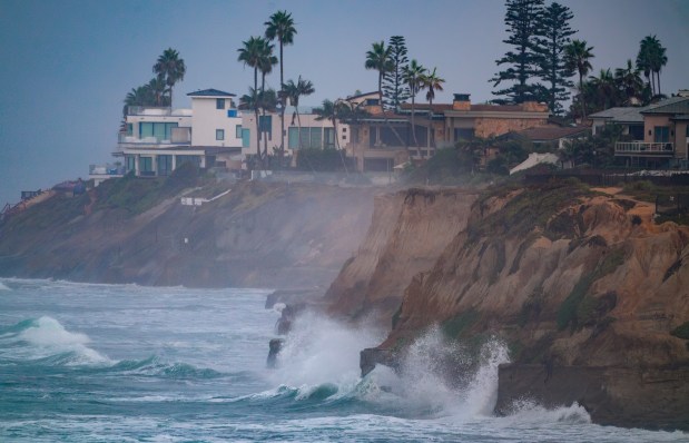 Coastal homes in Carlsbad overlook the high surf on Friday. (Nelvin C. Cepeda / The San Diego Union-Tribune)
Warmer water reduces chlorophyll and phytoplankton in the ocean, creating a food scarcity for birds and marine life, Carter said. The higher temperatures also slow the growth of giant kelp, which evolved to thrive in a colder, nutrient-rich environment and provides a home for many marine species.
Also, fish, birds and sea mammals, such as the olive ridley sea turtle, that normally live in more tropical southern waters are turning up in greater numbers along the California coast.
Scientists also, for about two decades now, have used a global system of solo floats called Argo to collect data on ocean temperatures. The floats show increasing temperatures in recent months on top of what already was considered “a marine heat wave,” said Daniel Rudnick, a physical oceanographer at Scripps.
“Warmer water takes up more volume, so you have a higher sea level,” Rudnick said.
Climate scientists say the warmer water could add 6 to 12 inches to background sea levels. That can become a major concern when combined with highest tides of the year, known as the king tides, that occur a few days a month every winter.
This year’s king tides will peak on or about Oct. 27, Nov. 24, Dec. 24 and Jan. 22.
Erosion
Coastal flooding usually occurs during king tides. Should a powerful local storm or a strong swell from a distant storm arrive at the same time, erosion and flooding is almost certain.
“These (tides) really increase the chance for damage along our coastline,” said Adam Young, a coastal geomorphologist with the Scripps Coastal Processes Group. “This really impacts the region as a whole.”
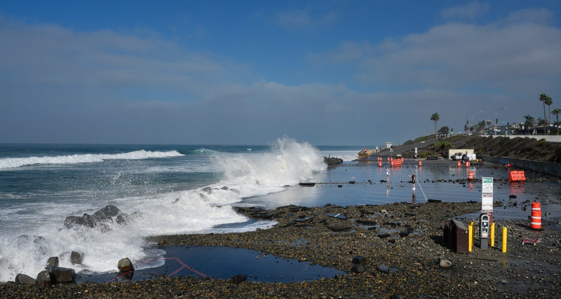
San Diego County’s coastline has a number of vulnerable areas. Waves often crash onto beachfront streets such as The Strand in Oceanside, sending cobblestones onto the pavement and seawater into garages.
In Carlsbad, the high tides sometimes force the closure of the low-lying southbound lanes of Carlsbad Boulevard, also known as Highway 101, at the outlet of Encinas Creek. Last month, the city declared a local emergency to expedite repairs after fresh erosion threatened to undermine the highway at a spot just north of the creek and south of Palomar Airport Road.
In recent weeks, the northern section of Carlsbad State Beach between Tamarack and Pine avenues has seen some of the worst erosion in memory for most residents. The Tamarack Avenue parking lot has been closed to vehicles since Labor Day weekend because of damage to the asphalt there.
A state official said last week that plans are underway for parking lot repairs that should be finished by the end of the year.
Most San Diego County beaches lost sand to the prevailing ocean currents over the summer, though it’s usually a season of natural rebuilding in the cyclical life of the coastline.
Bluff-top homes in Encinitas and Solana Beach have been fighting erosion for years by adding, expanding or rebuilding seawalls. This winter’s storms, if true to the forecast, could bring new hazards for those properties.
King tides flooded buildings along and near Mission Beach’s Bayside Walk in July this year, an inconvenience usually more likely to occur in December and January.
Coastal cities from Oceanside to San Diego have created teams of municipal employees to review their flood-response procedures and begin clearing storm drains and creeks in preparation for the expected El Niño.
A section of San Diego’s only railroad connection to Los Angeles and the rest of the United States also is threatened by the prospect of a rising sea.
About 1.7 miles of the track runs along a high, seaside bluff in Del Mar. Transit agencies and regional planners have been installing seawalls, retaining walls, pilings and other measures for decades to stabilize the steep slopes at the edge of the ocean.
However, a single landslide there could stop all passenger and freight trains in and out of San Diego until emergency repairs are completed.
The segment is part of what’s known as the Los Angeles-San Diego-San Luis Obispo (LOSSAN) Rail Corridor that covers 351 miles between San Diego and San Luis Obispo. One of the busiest routes in the nation, it carries daily Amtrack passenger trains and Coaster commuter trains, as well as nightly BNSF freight trains that carry thousands of new cars and other valuable products between the Port of San Diego and Los Angeles.
Another trouble spot on the rail corridor is at San Clemente, in Orange County just north of Camp Pendleton. About seven miles of the railroad tracks in southern Orange County runs along the beach, low enough for waves to wash over the tracks at high tide in some places.
Several times this year high surf shorted out railroad communications systems and eroded some of the gravel ballast beneath the tracks near the San Clemente Pier, delaying or stopping some trains.
Long-term plans call for relocating both railroad trouble spots inland, probably to a new route near Interstate 5. However, that unfunded solution would cost billions of dollars with dim prospects for that much state or federal grant money.
Planners have said a new route through a tunnel in Del Mar could be completed by 2035, but that target could be optimistic, and a solution for San Clemente is much further in the future.