Evacuations underway in NC due to Hurricane Erin; life-threatening rip currents expected in SC
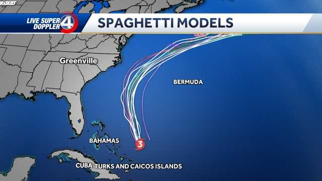
All eyes on air and *** powerful CAT 4 that’s going to brush up against the Outer Banks and cause high impacts. Let me show you this storm system is getting wider and more organized and intense. This is going to continue to be *** CAT 4 for at least another 24 hours. Then this week, as wind shear starts to get it, it’ll be down to *** CAT 3 or CAT 2. However, the wind field’s going to expand and the size of this system. Let me show it to you. Spaghetti models are in great agreement with this brushing right up again. The Outer Banks. Now remember, these spaghetti models show you where the center goes, not where the storm. Those winds extend out almost 400 miles on either side. Let me show you that wind field. Look how wide this is and how just enormous Erin is going to be as it passes by the Carolinas. This brings in high rip currents for the South Carolina coast, but right now, South Carolina looks fine. It’s North Carolina due to the geography here, that some of those more intense winds start to get into. The Outer Banks. Let me get in closer here and show you that push of water, that push of wind into there is going to cause some coastal flooding all up and down the Outer Banks. Why we have some evacuations. There could be 20 to 25 ft waves over land in those areas, which is going to cause some significant issues all along the Cape Hatteras up through Nags Head. We’ll be watching that closely. That pulls away. Then our eyes turned to *** secondary system which is right behind Aaron following in *** very similar path, *** 60% chance now we’ll have *** system number 2 here which will be named for no. Let me show you the agreement and the models. They’re in great agreement here with the wind field, the size of the wind field with Aaron that moves away. Then we have *** system cropping up here. They both agree with something cropping up near Puerto Rico late this week. They disagree from there. The European. I wants to curve this out almost identically to where Aaron went while the GFS gets stronger, bigger and brings it close to South Florida right there where we could have *** strong hurricane early next week. Right now, the models need *** little more time. The GFS has been more aggressive at sending it toward the United States. We’re also early. What we know, there’s going to be *** system. It’s going to be heading toward the west. We just don’t know the track yet, which we’ll keep, keep you posted on.
Evacuations underway in NC due to Hurricane Erin; life-threatening rip currents expected in SC

Updated: 9:51 PM EDT Aug 18, 2025
Latest information on Hurricane Erin, including track and spaghetti models. This story will also highlight the impacts expected along the East Coast. 2 p.m. Monday:Hurricane Erin is a Category 4 storm with winds of 140 mph.Evacuations are underway at Hatteras Island and Ocracoke Island in North Carolina due to possible 25 foot waves.Myrtle Beach could see 7–10-foot seas, breaking waves of 5+ feet, and life-threatening rip currents.Tropical Storm Alerts are in effect for the Turks & Caicos and the southeastern Bahamas.Tropical Storm Watch is in effect for Central Bahamas. Hurricane Stats:Hurricane Track:Spaghetti Models:Impacts Expected to the SC and NC CoastHurricane Erin’s track remains steady, bringing it offshore of the Outer Banks by late Wednesday.A closer brush would bring winds of 60 to 70 mph into Thursday morning. Waves along the Outer Banks could reach 25 feet, creating dangerous coastal flooding and overwash. Mandatory evacuations are already underway.For the South Carolina coast, rip currents will be the main concern, along with wave heights of 5 to 7 feet.
Latest information on Hurricane Erin, including track and spaghetti models. This story will also highlight the impacts expected along the East Coast.
2 p.m. Monday:
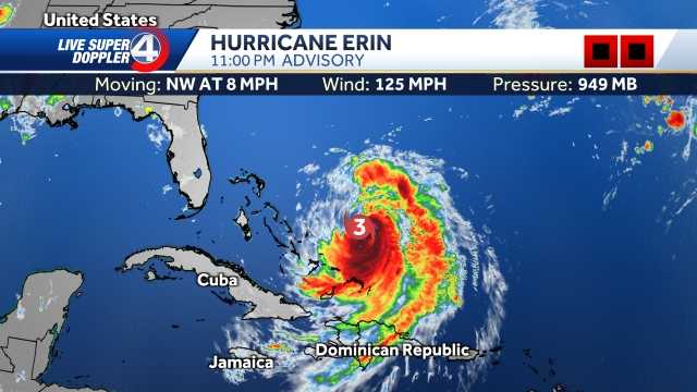
Hurricane Erin is a Category 4 storm with winds of 140 mph.Evacuations are underway at Hatteras Island and Ocracoke Island in North Carolina due to possible 25 foot waves.Myrtle Beach could see 7–10-foot seas, breaking waves of 5+ feet, and life-threatening rip currents.Tropical Storm Alerts are in effect for the Turks & Caicos and the southeastern Bahamas.Tropical Storm Watch is in effect for Central Bahamas.
Hurricane Stats:

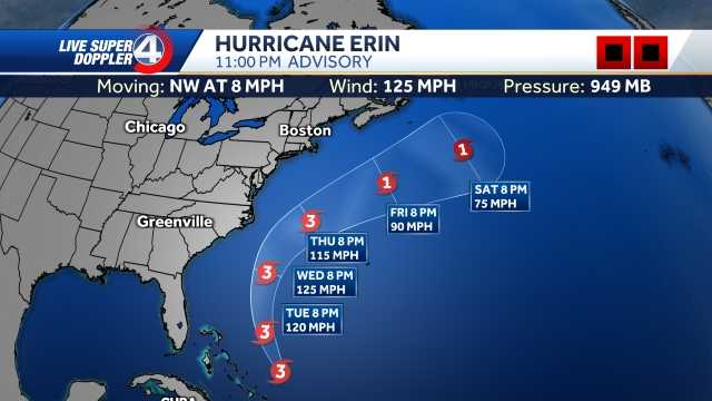
Hurricane Track:

Spaghetti Models:

Impacts Expected to the SC and NC Coast
Hurricane Erin’s track remains steady, bringing it offshore of the Outer Banks by late Wednesday.
A closer brush would bring winds of 60 to 70 mph into Thursday morning. Waves along the Outer Banks could reach 25 feet, creating dangerous coastal flooding and overwash. Mandatory evacuations are already underway.
For the South Carolina coast, rip currents will be the main concern, along with wave heights of 5 to 7 feet.

