
UNIVERSITY OF HAWAII
UH researchers attempt to find fresh water hidden deep beneath the seafloor.
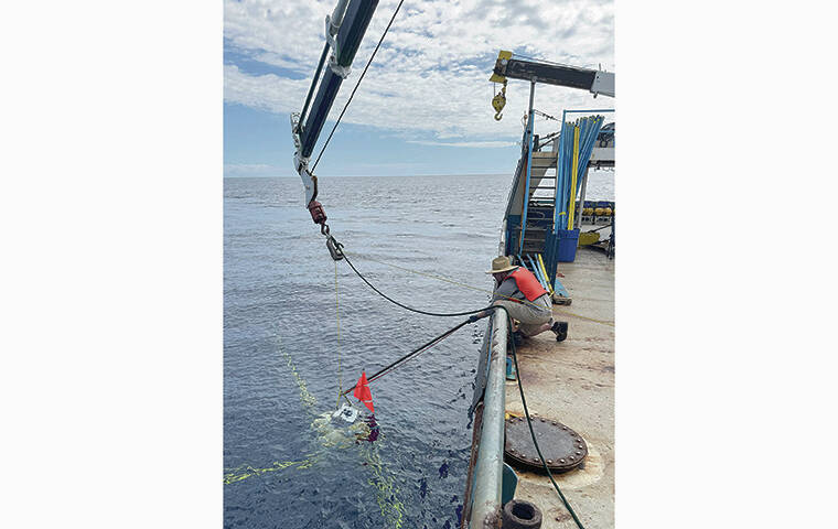
A scientific expedition off the west coast of Hawaii island recently concluded a two-week offshore imaging survey aimed at confirming the existence of a vast underground reservoir of fresh or brackish water beneath the seafloor.
The survey, conducted last month, involved researchers from the University of Hawaii at Manoa and Scripps Institution of Oceanography, working under
contract with the Natural Energy Laboratory of Hawaii Authority and funded by the state Legislature.
The study seeks to verify a theory that challenges current understanding of island hydrology: that a deep, confined aquifer of fresh water or brackish water lies trapped beneath layers of volcanic basalt and ash, extending miles offshore.
“If proven, this deep water could explain long- standing mysteries about Hawaii Island’s water cycle — namely, why observed coastal discharge doesn’t match estimated groundwater recharge,” said Peter Kannberg, associate researcher at the Hawaii Institute of Geophysics and Planetology in UH Manoa’s School of Ocean and Earth Science and Technology, who led the survey. “In simple terms, a lot of water is missing from current models.”
The investigation originated in 2018 when scientists first detected irregularities suggesting the presence of this deep aquifer where none was expected. The theory states that rainwater may be funneled underground and trapped beneath the basal freshwater lens, which lies closer to the surface, extending far beneath the seafloor and offshore.
The 2025 expedition utilized advanced electromagnetic imaging technology. Instruments deployed on the seafloor detected electromagnetic echoes, while a 150-foot-long towed sensor emitted a low-power signal recorded by a 3,300-foot-long receiver array. The survey covered two coastal areas of West Hawaii: north of Kiholo Bay to Honokohau Harbor and from south of Kailua Bay to Kealakekua.
Don’t miss out on what’s happening!
Stay in touch with breaking news, as it happens, conveniently in your email inbox. It’s FREE!
“What we are learning is that the extent of these offshore aquifers is greater than we originally thought, both in breadth and depth,” Kannberg said. “So we have had to leverage different scientific methods to see deep enough into the earth to adequately capture these complex hydrologic systems. Typically for these offshore aquifer surveys, being able to image 1,000 feet below the seafloor is sufficient. Here in Hawaii, we have found that we need to be able to see up to 10 times that to adequately resolve these aquifers.”
Researchers are now processing the collected data to confirm the reservoir’s existence and to estimate the volume of water stored
offshore.
“The next steps will be to turn the data we collected into a model of the earth offshore Kona,” Kannberg said. “This model will verify the existence and extent of these offshore aquifers. Once we know how and where these features are, we will be able to make informed policies about the management of these resources.
“Our current conceptual model of how fresh water should work on islands does not allow for offshore aquifers to exist,” he said. “If we are able to show they do
exist, then we need to reevaluate those conceptual models, and update them to reflect the reality that we are seeing.”
Kannberg also addressed the environmental trade-offs of potentially accessing this offshore reservoir.
“These deep aquifers are unlikely to be pure fresh water. If they were to be used as a drinking water source, desalination would likely be necessary. But rather than looking at these features
as a potential new water source, we need to look
at how the existence of these deeper aquifers affects our understanding of freshwater resources across the islands.”
The implications of the
research extend beyond
Hawaii island.
“We have done a similar study offshore southern Oahu, where we found significant volumes of freshened water offshore,” Kannberg said. “There have been a number of studies of offshore fresh water, but almost all of them have been in nonvolcanic environments. The volcanic geology of the islands increases the hydrologic complexity significantly.
“Water flowing through sand is much simpler to understand and model than water flowing through fractures and lava tubes. To understand it, we need to gather as much information as we can, both onshore and offshore, using all available technologies. While our survey is focused on the Kona coast, it will provide a foundation for understanding freshwater resources on volcanic islands both here and abroad.”