The Gulf Coast Hurricane Tracking Team continues to monitor Hurricane Erin in the Atlantic Ocean.As of 8 a.m. Wednesday, Erin is a Category 2 hurricane moving to the north-northwest at 13 mph with sustained winds at 100 mph. The storm is 400 miles south-southeast of Cape Hatteras, North Carolina.Hurricane Week: Stories of survival, science, and recovery on the Gulf Coast Erin will continue to stay well offshore from Florida’s Atlantic coast and poses no threat to southwest Florida. The Main Threats Dangerous Surf: The swells from Erin will lead to dangerous seas and an increased rip current risk. Wave heights will build to over 40 feet offshore near the center of the storm, while 10-15 foot waves will be seen from the east coast of Florida northward to coastal New England. Swimming at most U.S. east coast beaches will remain dangerous over the next few days due to life-threatening rip currents.Wind: According to the NHC, hurricane-force winds now extend up to 90 miles from the center and tropical-storm force winds extend up to 265 miles from the center. A tropical storm warning remains in effect for the North Carolina coast from Beaufort Inlet to Duck. A tropical storm watch is in effect for areas north of Duck, North Carolina, to Chincoteague, Virginia. Storm Surge: A storm surge warning is in effect for the North Carolina coast from Cape Lookout to Duck where 2-4 feet of surge is possible. Rain: The outer bands from the hurricane will bring 1-2 inches of rain to coastal North Carolina.We will continue to track Erin closely and alert you of any changes in the forecast. Other areas we’re watching Beyond Erin, the Gulf Coast Storm Team is monitoring two areas of interest in the Atlantic. A tropical wave in the central tropical Atlantic has a medium chance of development as it moves to the west-northwest at about 20 mph. A tropical depression is possible as the disturbance tracks north of the Leeward Islands toward the end of the week. A second tropical wave, located southwest of the Cabo Verde Islands, is tracking to the west at 15 mph. This disturbance could become a short-lived tropical depression but conditions will become unfavorable for development by the end of the week. The next storm name is Fernand. Hurricane WeekIsland Park neighbors concerned about flooding, Lee County working on solutionsMatlacha pushes forward as last storm-damaged buildings set for demolitionFort Myers resident installs flood barriers to protect home and car’Each tree and each site is going to be different’: Ways to prepare trees for hurricane seasonIs your home really hurricane-resistant? Inspector shares what to checkManasota Key bounces back from Hurricane Milton, prepares for future stormsParadise shaken, not broken: Manasota Key residents look back on Hurricane Milton’s tollThe Atlantic hurricane season runs from June 1 through Nov. 30. Follow Gulf Coast News online and on air for Southwest Florida’s Most Accurate weather forecast.Be prepared with the Gulf Coast News 2025 Hurricane GuideLive Interactive RadarCheck out the interactive Gulf Coast Live RadarWatch your Gulf Coast Weather forecasts on TV or onlineHere’s where to find our latest weather forecast videoYou can also watch newscasts live or on demand hereOr download the Gulf Coast News app to stream on your phone or tabletFollow the Gulf Coast Storm Team on social mediaChief Meteorologist Allyson Rae on Facebook and XMeteorologist Caroline Castora on Facebook and XMeteorologist Jim Dickey on Facebook and XMeteorologist Jason Dunning on Facebook and XMeteorologist Rob Duns on Facebook and XMeteorologist Lauren Hope on Facebook and XMeteorologist Raphael Tavernier on Facebook and XDOWNLOAD the free Gulf Coast News app for your latest breaking news and weather alerts. And check out the Very Local Gulf Coast app to stream news, entertainment and original programming on your TV.
The Gulf Coast Hurricane Tracking Team continues to monitor Hurricane Erin in the Atlantic Ocean.
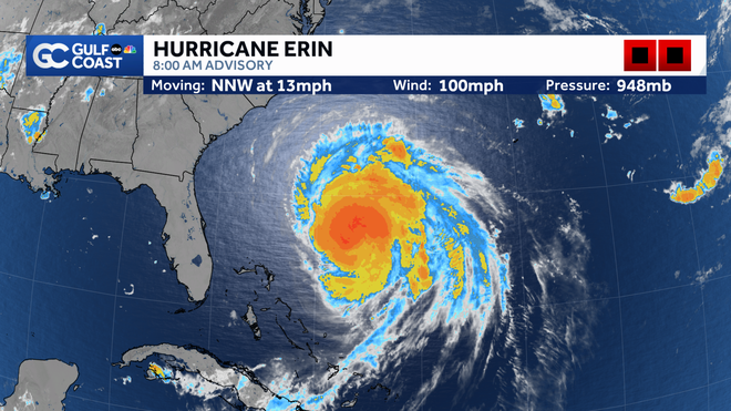
As of 8 a.m. Wednesday, Erin is a Category 2 hurricane moving to the north-northwest at 13 mph with sustained winds at 100 mph. The storm is 400 miles south-southeast of Cape Hatteras, North Carolina.
Gulf Coast News
Hurricane Erin
Hurricane Week: Stories of survival, science, and recovery on the Gulf Coast
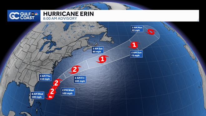
Erin will continue to stay well offshore from Florida’s Atlantic coast and poses no threat to southwest Florida.
Gulf Coast News
Hurricane Erin
The Main Threats
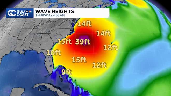
Dangerous Surf: The swells from Erin will lead to dangerous seas and an increased rip current risk. Wave heights will build to over 40 feet offshore near the center of the storm, while 10-15 foot waves will be seen from the east coast of Florida northward to coastal New England. Swimming at most U.S. east coast beaches will remain dangerous over the next few days due to life-threatening rip currents.
Gulf Coast News
Erin Model Wave Heights
Wind: According to the NHC, hurricane-force winds now extend up to 90 miles from the center and tropical-storm force winds extend up to 265 miles from the center. A tropical storm warning remains in effect for the North Carolina coast from Beaufort Inlet to Duck. A tropical storm watch is in effect for areas north of Duck, North Carolina, to Chincoteague, Virginia.
Storm Surge: A storm surge warning is in effect for the North Carolina coast from Cape Lookout to Duck where 2-4 feet of surge is possible.
Rain: The outer bands from the hurricane will bring 1-2 inches of rain to coastal North Carolina.
We will continue to track Erin closely and alert you of any changes in the forecast.
Other areas we’re watching
Beyond Erin, the Gulf Coast Storm Team is monitoring two areas of interest in the Atlantic.
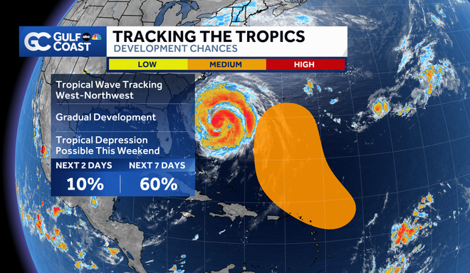
A tropical wave in the central tropical Atlantic has a medium chance of development as it moves to the west-northwest at about 20 mph. A tropical depression is possible as the disturbance tracks north of the Leeward Islands toward the end of the week.
Gulf Coast News
Area of Interest
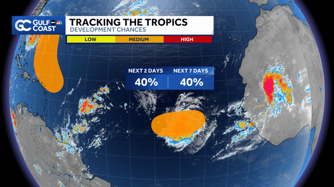
A second tropical wave, located southwest of the Cabo Verde Islands, is tracking to the west at 15 mph. This disturbance could become a short-lived tropical depression but conditions will become unfavorable for development by the end of the week.
Gulf Coast News
Area of Interest
The next storm name is Fernand.
Hurricane Week
The Atlantic hurricane season runs from June 1 through Nov. 30. Follow Gulf Coast News online and on air for Southwest Florida’s Most Accurate weather forecast.
Live Interactive Radar
Watch your Gulf Coast Weather forecasts on TV or online
Follow the Gulf Coast Storm Team on social media
Chief Meteorologist Allyson Rae on Facebook and XMeteorologist Caroline Castora on Facebook and XMeteorologist Jim Dickey on Facebook and XMeteorologist Jason Dunning on Facebook and XMeteorologist Rob Duns on Facebook and XMeteorologist Lauren Hope on Facebook and XMeteorologist Raphael Tavernier on Facebook and X
DOWNLOAD the free Gulf Coast News app for your latest breaking news and weather alerts. And check out the Very Local Gulf Coast app to stream news, entertainment and original programming on your TV.

