Hurricane Erin is moving away from the Carolina coast, rip current risk continues
THURSDAY: A 40 PERCENT CHANCE OF SHOWERS AND THUNDERSTORMS, MAINLY AFTER 3PM. MOSTLY SUNNY, WITH A HIGH NEAR 88. NORTH NORTHEAST WIND 3 TO 5 MPH. NEW RAINFALL AMOUNTS OF LESS THAN A TENTH OF AN INCH, EXCEPT HIGHER AMOUNTS POSSIBLE IN THUNDERSTORMS. THURSDAY NIGHT: A 40 PERCENT CHANCE OF SHOWERS AND THUNDERSTORMS, MAINLY AFTER 10PM. MOSTLY CLOUDY, WITH A LOW AROUND 70. CALM WIND BECOMING NORTH NORTHEAST AROUND 5 MPH AFTER MIDNIGHT. NEW RAINFALL AMOUNTS BETWEEN A TENTH AND QUARTER OF AN INCH, EXCEPT HIGHER AMOUNTS POSSIBLE IN THUNDERSTORMS. FRIDAY: A 40 PERCENT CHANCE OF SHOWERS AND THUNDERSTORMS, MAINLY AFTER 2PM. PATCHY FOG BEFORE 10AM. OTHERWISE, MOSTLY CLOUDY, WITH A HIGH NEAR 81. EAST WIND AROUND 7 MPH. NEW RAINFALL AMOUNTS BETWEEN A TENTH AND QUARTER OF AN INCH, EXCEPT HIGHER AMOUNTS POSSIBLE IN THUNDERSTORMS. FRIDAY NIGHT: A CHANCE OF SHOWERS AND THUNDERSTORMS. MOSTLY CLOUDY, WITH A LOW AROUND 68. LIGHT NORTHEAST WIND. CHANCE OF PRECIPITATION IS 40%. SATURDAY: A CHANCE OF SHOWERS, WITH THUNDERSTORMS ALSO POSSIBLE AFTER 2PM. PARTLY SUNNY, WITH A HIGH NEAR 82. CHANCE OF PRECIPITATION IS 40%. SATURDAY NIGHT: A CHANCE OF SHOWERS AND THUNDERSTORMS BEFORE 8PM, THEN A CHANCE OF SHOWERS BETWEEN 8PM AND 10PM. MOSTLY CLOUDY, WITH A LOW AROUND 67. CHANCE OF PRECIPITATION IS 30%. SUNDAY: A 40 PERCENT CHANCE OF SHOWERS AND THUNDERSTORMS AFTER 2PM. PARTLY SUNNY, WITH A HIGH NEAR 83. SUNDAY NIGHT: A 30 PERCENT CHANCE OF SHOWERS AND THUNDERSTORMS BEFORE 8PM. PARTLY CLOUDY, WITH A LOW AROUND 66. MONDAY: SUNNY, WITH A HIGH NEAR 86. MONDAY NIGHT: MOSTLY CLEAR, WITH A LOW AROUND 62. TUESDAY: MOSTLY SUNNY, WITH A HIGH NEAR 81. THURSDAY: A 40 PERCENT CHANCE OF SHOWERS AND THUNDERSTORMS, MAINLY AFTER 3PM. MOSTLY SUNNY, WITH A HIGH NEAR 88. NORTH NORTHEAST WIND 3 TO 5 MPH. NEW RAINFALL AMOUNTS OF LESS THAN A TENTH OF AN INCH, EXCEPT HIGHER AMOUNTS POSSIBLE IN THUNDERSTORMS. THURSDAY NIGHT: A 40 PERCENT CHANCE OF SHOWERS AND THUNDERSTORMS, MAINLY AFTER 10PM. MOSTLY CLOUDY, WITH A LOW AROUND 70. CALM WIND BECOMING NORTH NORTHEAST AROUND 5 MPH AFTER MIDNIGHT. NEW RAINFALL AMOUNTS BETWEEN A TENTH AND QUARTER
Hurricane Erin is moving away from the Carolina coast, rip current risk continues

Updated: 7:12 AM EDT Aug 21, 2025
Hurricane Erin battered North Carolina’s Outer Banks with strong winds and waves that flooded part of the main highway and surged under beachfront homes as the monster storm slowly began to move away from the East Coast on Thursday.Forecasters predicted the storm would peak Thursday and said it could regain strength and once again become a major hurricane, Category 3 or greater, but it was not forecast to make landfall along the East Coast before turning farther out to sea.As of 5 a.m. Thursday, Hurricane Erin is a Category 2 with winds of 105 mph. About 205 miles east-southeast of Cape Hatteras, North Carolina. Here are the continued impacts to the Carolina coasts:Outer Banks Impacts through Friday:Storm surge up to 4 feet possible.Breaking waves, also known as surf, up to 15 to 20+ feet on the oceanside.Sustained wind of 20 to 35, gusts up to around 50 mph.Extreme beach, coastal damage, and severe saltwater inundation.Myrtle Beach Impacts through Thursday:6 to 11 foot seas.Breaking waves (surf) of up to 7 feet.Life-threatening rip currents. Hurricane Stats:Hurricane Track:Spaghetti Models:A tropical wave located several hundred miles east of the Leeward Islands may gradually develop and strengthen into a tropical depression by this weekend while it moves near or to the north of the northern Leeward Islands. A medium chance of development over the next 7 days.An area of showers and storms in the far eastern Atlantic may form into a tropical depression by the end of the week. Heading into the weekend, environmental conditions are expected to become unfavorable for further development. A medium chance of development within the next two days.
GREENVILLE, S.C. —
Hurricane Erin battered North Carolina’s Outer Banks with strong winds and waves that flooded part of the main highway and surged under beachfront homes as the monster storm slowly began to move away from the East Coast on Thursday.
Forecasters predicted the storm would peak Thursday and said it could regain strength and once again become a major hurricane, Category 3 or greater, but it was not forecast to make landfall along the East Coast before turning farther out to sea.
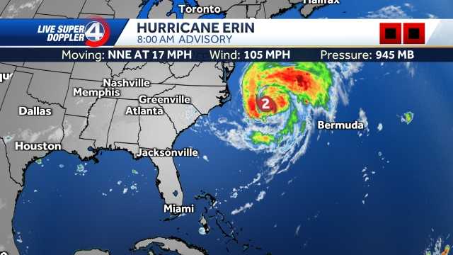
As of 5 a.m. Thursday, Hurricane Erin is a Category 2 with winds of 105 mph. About 205 miles east-southeast of Cape Hatteras, North Carolina.
Here are the continued impacts to the Carolina coasts:
Outer Banks Impacts through Friday:
Storm surge up to 4 feet possible.Breaking waves, also known as surf, up to 15 to 20+ feet on the oceanside.Sustained wind of 20 to 35, gusts up to around 50 mph.Extreme beach, coastal damage, and severe saltwater inundation.
Myrtle Beach Impacts through Thursday:
6 to 11 foot seas.Breaking waves (surf) of up to 7 feet.Life-threatening rip currents.
Hurricane Stats:

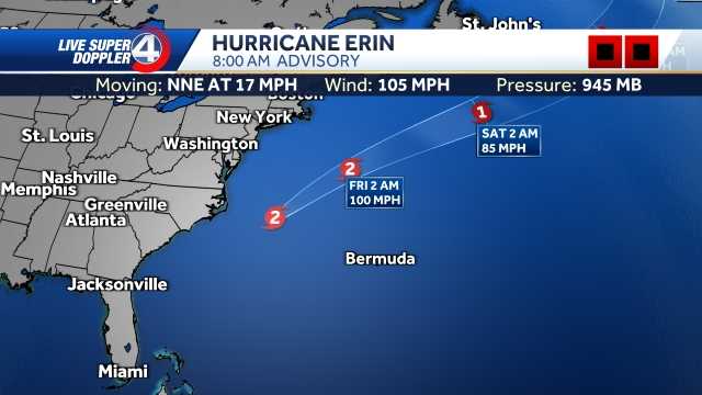
Hurricane Track:

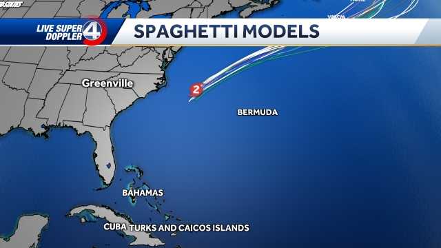
Spaghetti Models:

A tropical wave located several hundred miles east of the Leeward Islands may gradually develop and strengthen into a tropical depression by this weekend while it moves near or to the north of the northern Leeward Islands. A medium chance of development over the next 7 days.
An area of showers and storms in the far eastern Atlantic may form into a tropical depression by the end of the week. Heading into the weekend, environmental conditions are expected to become unfavorable for further development. A medium chance of development within the next two days.

