Hurricane Erin is pulling away from the North Carolina coast, but its far-reaching effects are causing flooding, rip currents and bigger waves along East Coast beaches.Get the latest updates below:Gov. Josh Stein has declared a State of Emergency as North Carolina prepares for impacts from Hurricane Erin.Expected to bring coastal flooding, beach erosion, and dangerous surf conditions.National Guard and swift water rescue teams at the ready.►Get the latest forecast here.►Check out live interactive radar, here ►Check out the latest weather alerts for your areaTHURSDAY, AUG. 2112:10 p.m.- NC Emergency Managers announce double red flags are posted at all beaches in Dare County and warn that conditions can still get worse as Erin moves offshore.12:00 p.m.- Storm surge and strong waves are expected to continue despite the storm beginning to speed up and away from the coast. The latest update from the National Hurricane Center urges everyone to take caution and heed the warnings posted at beaches along the east coast. 11:30 a.m. – Erin’s swells are hitting the Kitty Hawk Pier check out the video below. 11:15 a.m. – NC-12 through the Outer Banks has been significantly impacted over the past 12-18 hours, according to the NWS Newport/Morehead. 11 a.m. – Hurricane Erin is still a category 2 Hurricane off the coast of North Carolina.10:45 a.m. – Check out the flooding on N.C. Highway 12 as Hurricane Erin continues to flood the area. 9:48 a.m. – NCDOT camera captures Erin flooding in the Outer Banks. 9:32 a.m. – Hurricane Erin is churning the Atlantic and creating heavy waves along the coast of North Carolina. 8:25 a.m.- The high tide in Dare County is now over and Emergency Management reports many roads are still covered in sand and water. 8:00 a.m.- The National Hurricane Center releases its latest update that shows Erin is 210 miles east of Cape Hatteras and moving away.7:59 a.m.- Our Chris Petersen has the latest from Nags Head.6:53 a.m.- Dunes have failed in parts of the Outer Banks. Strong waves are expected to continue as Erin moves offshore6:19 a.m.- In Hatteras, the effects of Erin can start to be seen along the coast of North Carolina. 6:00 a.m.- Strong and frequent waves are being seen along the coast of the Outer Banks as the sun rises 5:40 a.m.- Erin appears to start a shift to the northeast, moving more offshore than earlier in the morning5:24 a.m. – Dangerous and life-threatening rip current warnings for the North Carolina coast due to Erin’s swells. 5 a.m. – Erin on radar, making its closest pass to the Outer Banks. 4 a.m. – Hurricane Erin is nearing the closest approach to North Carolina. The latest report from the National Hurricane Center positioned the storm 200 miles southeast of Hatteras.WEDNESDAY, AUG. 20 9 p.m. – Two CH-47 helicopters from neighboring states are on standby to transport food and water, if necessary, according to state emergency officials.8:30 p.m. – The State Emergency Response Team has swift water rescue teams on standby. North Carolina Gov. Josh Stein also said National Guard troops are at the ready along with boats, high-clearance vehicles, and aircraft. 8 p.m. – N.C. Highway 12 from Oregon Inlet to Hatteras Village is closed, as conditions are too unsafe for people to be driving in.7 p.m. – Large swells are bringing 8-10-foot waves. The video below was captured by Ron Fisher in Atlantic Beach Wednesday evening as beach goers took a walk on the shore looking at the high surf and rip currents.5 p.m. – Chris Petersen reports from the Outer Banks on what transportation leaders are expecting from Erin.4:30 p.m. – Lanie Pope and Dave Aiken give an update as Hurricane Erin closes in on the North Carolina coast.4:00 p.m. – A flash flood warning is in effect for Alleghany, Grayson, and Wilkes Counties until 10 p.m.12:00 p.m. – WXII’s Michelle Kennedy gives an update on Hurricane Erin’s track and the impact it could have on North Carolina.
Hurricane Erin is pulling away from the North Carolina coast, but its far-reaching effects are causing flooding, rip currents and bigger waves along East Coast beaches.
Get the latest updates below:
Gov. Josh Stein has declared a State of Emergency as North Carolina prepares for impacts from Hurricane Erin.Expected to bring coastal flooding, beach erosion, and dangerous surf conditions.National Guard and swift water rescue teams at the ready.
►Get the latest forecast here.
►Check out live interactive radar, here
►Check out the latest weather alerts for your area
THURSDAY, AUG. 21
12:10 p.m.- NC Emergency Managers announce double red flags are posted at all beaches in Dare County and warn that conditions can still get worse as Erin moves offshore.
This content is imported from Facebook.
You may be able to find the same content in another format, or you may be able to find more information, at their web site.
12:00 p.m.- Storm surge and strong waves are expected to continue despite the storm beginning to speed up and away from the coast. The latest update from the National Hurricane Center urges everyone to take caution and heed the warnings posted at beaches along the east coast.
11:30 a.m. – Erin’s swells are hitting the Kitty Hawk Pier check out the video below.
11:15 a.m. – NC-12 through the Outer Banks has been significantly impacted over the past 12-18 hours, according to the NWS Newport/Morehead.
This content is imported from Twitter.
You may be able to find the same content in another format, or you may be able to find more information, at their web site.
⚠️NC-12 through the Outer Banks has been significantly impacted over the past 12-18 hours. Here is a look at current road conditions (courtesy @NCDOT_NC12 ). Please keep in mind that this will be a long-duration event for areas along NC-12. #Erin #ncwx pic.twitter.com/qO6n98DUo6
— NWS Newport/Morehead (@NWSMoreheadCity) August 21, 2025
11 a.m. – Hurricane Erin is still a category 2 Hurricane off the coast of North Carolina.
This content is imported from Twitter.
You may be able to find the same content in another format, or you may be able to find more information, at their web site.
Hurricane #Erin is still a category 2 Hurricane off the coast of North Carolina. Early Thursday morning the storm made its closest approach to the coast, located about 200 miles offshore. Strong winds and intense waves have been seen along parts of the Outer Banks. #tropic #nc pic.twitter.com/HlRTGlDVbY
— Brian Slocum (@brianslocumwxii) August 21, 2025
10:45 a.m. – Check out the flooding on N.C. Highway 12 as Hurricane Erin continues to flood the area.
9:48 a.m. – NCDOT camera captures Erin flooding in the Outer Banks.
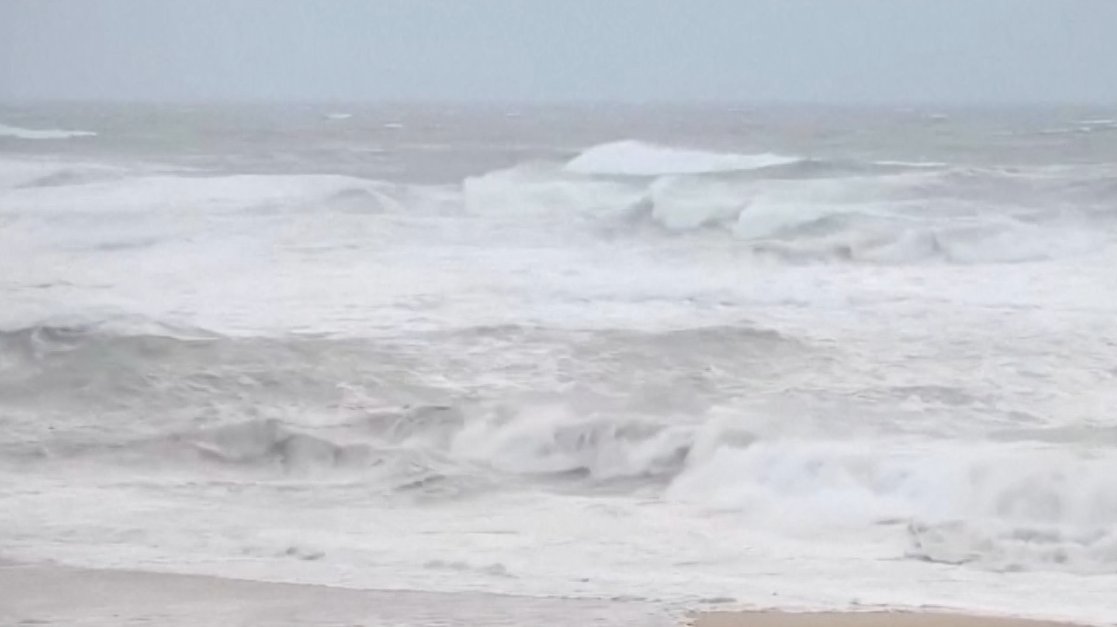
9:32 a.m. – Hurricane Erin is churning the Atlantic and creating heavy waves along the coast of North Carolina.
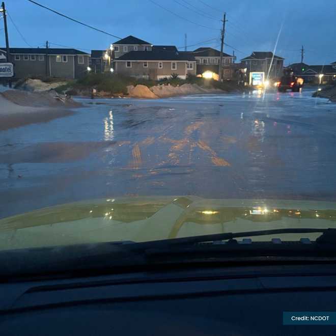
8:25 a.m.- The high tide in Dare County is now over and Emergency Management reports many roads are still covered in sand and water.

FacebookNC DOT
NC DOT photo of water and sand on roads from Hurricane Erin
8:00 a.m.- The National Hurricane Center releases its latest update that shows Erin is 210 miles east of Cape Hatteras and moving away.
This content is imported from Twitter.
You may be able to find the same content in another format, or you may be able to find more information, at their web site.
Erin is 210 miles away from Cape Hatteras and is moving NNE away from the Carolina Coast. Strong waves and winds are expected to last through today but Erin should pick up speed and get out by the time the weekend rolls around!#erin #tropics #beach pic.twitter.com/KMUMJ5dd2t
— Michael Pardee (@pardee_wx) August 21, 2025
7:59 a.m.- Our Chris Petersen has the latest from Nags Head.
This content is imported from Facebook.
You may be able to find the same content in another format, or you may be able to find more information, at their web site.
6:53 a.m.- Dunes have failed in parts of the Outer Banks. Strong waves are expected to continue as Erin moves offshore
This content is imported from Twitter.
You may be able to find the same content in another format, or you may be able to find more information, at their web site.
6:19 a.m.- In Hatteras, the effects of Erin can start to be seen along the coast of North Carolina.
This content is imported from Twitter.
You may be able to find the same content in another format, or you may be able to find more information, at their web site.
Sunrise is starting to reveal the extent of #Erin‘s overnight impacts at the Outer Banks.
Hatteras Island looks to have taken the brunt of it, but Hwy 12 seems to be intact. #NCwx pic.twitter.com/qBVsx4LMTw
— Dylan Hudler (@DylanHudlerWXII) August 21, 2025
6:00 a.m.- Strong and frequent waves are being seen along the coast of the Outer Banks as the sun rises
5:40 a.m.- Erin appears to start a shift to the northeast, moving more offshore than earlier in the morning
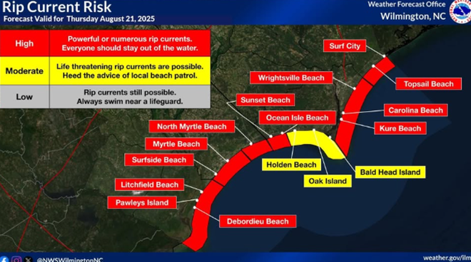
5:24 a.m. – Dangerous and life-threatening rip current warnings for the North Carolina coast due to Erin’s swells.

5 a.m. – Erin on radar, making its closest pass to the Outer Banks.
This content is imported from Twitter.
You may be able to find the same content in another format, or you may be able to find more information, at their web site.
4 a.m. – Hurricane Erin is nearing the closest approach to North Carolina. The latest report from the National Hurricane Center positioned the storm 200 miles southeast of Hatteras.
WEDNESDAY, AUG. 20
9 p.m. – Two CH-47 helicopters from neighboring states are on standby to transport food and water, if necessary, according to state emergency officials.
8:30 p.m. – The State Emergency Response Team has swift water rescue teams on standby. North Carolina Gov. Josh Stein also said National Guard troops are at the ready along with boats, high-clearance vehicles, and aircraft.
8 p.m. – N.C. Highway 12 from Oregon Inlet to Hatteras Village is closed, as conditions are too unsafe for people to be driving in.
This content is imported from Facebook.
You may be able to find the same content in another format, or you may be able to find more information, at their web site.
7 p.m. – Large swells are bringing 8-10-foot waves. The video below was captured by Ron Fisher in Atlantic Beach Wednesday evening as beach goers took a walk on the shore looking at the high surf and rip currents.
5 p.m. – Chris Petersen reports from the Outer Banks on what transportation leaders are expecting from Erin.
4:30 p.m. – Lanie Pope and Dave Aiken give an update as Hurricane Erin closes in on the North Carolina coast.
4:00 p.m. – A flash flood warning is in effect for Alleghany, Grayson, and Wilkes Counties until 10 p.m.
12:00 p.m. – WXII’s Michelle Kennedy gives an update on Hurricane Erin’s track and the impact it could have on North Carolina.

