
OVER THE SAME PLACE OVER AND OVER. SO THE NATIONAL WEATHER SERVICE HAS ALL OF NORTHWEST ARKANSAS AND A GOOD PORTION OF NORTHEASTERN OKLAHOMA IN A FLOOD WATCH UNTIL 1:00 THIS AFTERNOON. AND THESE ARE THE FOLKS THAT ARE SEEING THE HEAVIEST RAIN SHOWERS RIGHT NOW. BUT BECAUSE THERE HAS BEEN SO MUCH RAIN OVER A PARTICULAR AREA AT ONE TIME, THEY’VE KIND OF UPGRADED THE SITUATION TO A FLASH FLOOD WARNING. AND THAT IS THE AREA THAT IS RIGHT HERE IN THIS POLYGON THAT IS KIND OF THIS FLUORESCENT GREEN. THAT WOULD BE AREAS LIKE DECATUR JUST ON THE EDGE OF GRAVETTE GENTRY, SILOAM SPRINGS COLD COURT. NOW, OF COURSE, THEY’RE GOING TO BE SOME HEAVIER RAIN SHOWERS THAT ARE EVEN OUTSIDE OF THIS FLASH FLOOD WARNING AREA. BUT THIS IS THE AREA RIGHT NOW THAT WHEN I’VE BEEN LOOKING AT RAINFALL TOTALS, HAS SEEN TWO UP TO THREE INCHES OF RAIN IN THE LAST SIX HOURS. SO THIS IS THE BIG PICTURE. AND WE’VE GOT EVERYBODY ALONG THE EASTERN FRINGES OF THE VIEWING AREA. BUT MOST OF THE ACTIVITY RIGHT NOW IS NORTHEASTERN OKLAHOMA, NORTHWEST ARKANSAS STILL SPOKE TO THE LIGHTNING THAT HE WAS TALKING ABOUT SEEING IN SOME OF THE LIVE SHOTS. AND THAT’S WHAT I TELL PEOPLE TO LOOK FOR. WERE THOSE CLUSTERS OF LIGHTNING STRIKES ARE THAT’S WHERE A LOT OF THE ENERGY IS, AND THAT’S WHERE YOU HAVE YOUR THRUST AND YOUR HEAVIEST DOWNPOURS. MOST OF THE TIME IT’S BEEN RELATIVELY QUIET IN THE RIVER VALLEY, BUT MORE PEOPLE WILL BEGIN SEEING SHOWERS AND STORMS AS WE GET THROUGH THE MORNING. SO I JUST WANTED TO SHOW YOU THIS MODEL ESTIMATE FOR RAINFALL TOTALS BY LUNCHTIME TODAY. IT’S SAYING THAT AREAS AROUND SPRINGDALE COULD SEE UPWARDS OF FIVE INCHES OF RAIN. MAYBE NOT SO MUCH IN THE BELLA VISTA AREA, BUT THREE INCHES IS STILL A GOOD BIT AROUND GROVE. SIX INCHES IS JUST THAT MIDDLE SWATH OF REDS AND PINKS AND DARKER ORANGES FAYETTEVILLE MAYBE UP TO FOUR INCHES OF RAINFALL, AND HUNTSVILLE COULD BE ANOTHER ONE OF THOSE HOT SPOTS. NOW, WHAT YOU’LL NOTICE IS THESE NUMBERS AS WE MOVE INTO THE AFTERNOON, ARE NOT GOING TO CHANGE THAT MUCH. WHAT HAPPENS IS MORE AREAS ON THE EASTERN FRINGES OF OUR VIEWING AREA THROUGH THE AFTERNOON AND SOUTHERN PART OF THE VIEWING AREA START TO SEE MORE OF THE RAIN. AND THAT WILL HAPPEN JUST THROUGHOUT THE AFTERNOON AND INTO THE EVENING. BY THE TIME WE GET TO MIDNIGHT,
Flooding is possible Thursday in Northwest Arkansas and River Valley

Updated: 7:16 AM CDT Aug 28, 2025
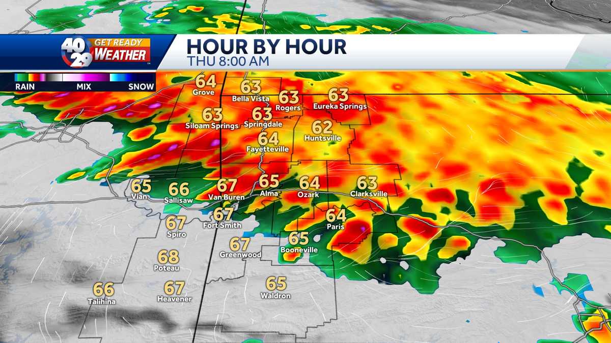
Flooding is possible in Northwest Arkansas and the River Valley on Thursday. The greatest threat is in Northwest Arkansas, but the threat in the River Valley is still present.Even if major flooding does not develop, there will be a lot of rain.The is impacting the Thursday morning drive in NWA. The River Valley is expected to receive rain in the afternoon.The weather is expected to quiet down in the late afternoon and evening.7-Day Forecast River Valley | 7-Day Forecast Northwest Arkansas | Interactive Radar | Live SkycamsOfficials in Northwest Arkansas have crews on standby in case of flash flooding.”In a certain way, we’re always prepared,” said Patrick Deakins, Washington County judge. “We always have the machinery ready. We can always dispatch and respond to anything we have. What we’ll do at the end of the business day is make sure trucks are fueled, chain saws are sharpened, and that we’re ready to respond to anything out there.””Flooding is the number one killer of weather events around the country, so it is extremely dangerous,” Kwok said. “People underestimate it a lot of the times. The water is deceptive, especially at night, which is when, unfortunately, we always seem to get this kind of weather.”Visit Us On YouTubeFollow Us For Weather & Traffic:Darby: Facebook | XDrake: Facebook | XLaura: Facebook | XShare photos of the weather in your area by joining our u local Arkansas Facebook group.
FAYETTEVILLE, Ark. —
Flooding is possible in Northwest Arkansas and the River Valley on Thursday.
The greatest threat is in Northwest Arkansas, but the threat in the River Valley is still present.
Even if major flooding does not develop, there will be a lot of rain.
The is impacting the Thursday morning drive in NWA. The River Valley is expected to receive rain in the afternoon.
The weather is expected to quiet down in the late afternoon and evening.
7-Day Forecast River Valley | 7-Day Forecast Northwest Arkansas | Interactive Radar | Live Skycams
Officials in Northwest Arkansas have crews on standby in case of flash flooding.
“In a certain way, we’re always prepared,” said Patrick Deakins, Washington County judge. “We always have the machinery ready. We can always dispatch and respond to anything we have. What we’ll do at the end of the business day is make sure trucks are fueled, chain saws are sharpened, and that we’re ready to respond to anything out there.”
“Flooding is the number one killer of weather events around the country, so it is extremely dangerous,” Kwok said. “People underestimate it a lot of the times. The water is deceptive, especially at night, which is when, unfortunately, we always seem to get this kind of weather.”
Follow Us For Weather & Traffic:
Darby: Facebook | X
Drake: Facebook | X
Laura: Facebook | X
Share photos of the weather in your area by joining our u local Arkansas Facebook group.