
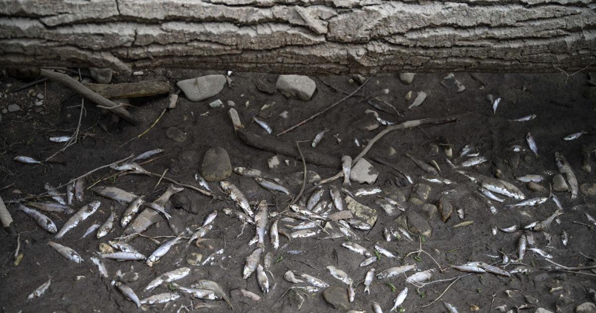
LOLO — It’s a Montana moment in late August, and the smell of decaying whitefish, suckers and crawdads dominates the last mile of a dusty creek bed in western Montana. Pools of standing water linger, but they’re drying up too fast to offer more than a dead end to the remaining fish. Vultures are circling overhead.
His boots crunching across the streambed, Jed Whiteley noted it’s certainly not the first time Lolo Creek has run dry before reaching the Bitterroot River. As of Tuesday, the creek petered out just past the Highway 93 bridge in a patchwork of shallow water, fish carcasses and exposed streambed. But it’s the worst he’s seen since at least 2017, the year of the Lolo Peak Fire.
“You get a big dry-out like this, and you’ve just wiped out an entire year’s class of fish and macroinvertebrates,” said Whiteley, the stream restoration director for the Clark Fork Coalition. “We always wonder, how long does it take for the creek to reboot?”
People are also reading…

Jed Whiteley, the stream restoration director for the Clark Fork Coalition, walks through Lolo Creek’s dried up streambed on Tuesday, Aug. 26 near Lolo.
SHANNA MADISON,Missoulian
For trout in the Bitterroot, the creek’s disappearance also cuts off an avenue of retreat to colder waters. Historically low flows and soaring water temperatures on the river have prompted “hoot owl” restrictions on fishing since mid-July in an effort to protect heat-stressed trout.
“It’s really important they can escape — they come here for their refuge,” Whiteley said. “Now that they’re disconnected, they’re stuck in the Bitterroot.”
Over time, the problems on Lolo Creek have shown up in the form of lower populations of native fish on the main stem of the Bitterroot. That’s according to Fish, Wildlife and Parks Fisheries Biologist Ladd Knotek.
“As we get these low water years, they’re more suitable for those nonnative species, like bass and pike,” Knotek said. “… It’s a stressful environment. It gets really warm, it’s a tough place to be a trout for three months out of the year.”
An unusually wet July helped somewhat. That month, 1.4 inches of rain fell at the Missoula airport, according to the National Weather Service — more than any July in almost a decade. But those showers didn’t erase a more than 2-inch precipitation deficit created over the prior three months. And that followed a poor mountain snowpack, a fast melt-off and ever-growing demands for surface and groundwater.
Jed Whiteley, the stream restoration director for the Clark Fork Coalition, walks through Lolo Creek’s dried up streambed on Tuesday, Aug. 26 near Lolo.
SHANNA MADISON,Missoulian
“We thought this would’ve happened about two weeks ago, and that’s what those rainstorms saved,” Whiteley said. And he noted it’s not just the fish that suffer. “Whether it’s insects, spiders, bats, birds, riparian vegetation. Our riparian corridors are by far our most diverse, productive areas in all of Montana.”
Lolo Creek is the third-largest source of water for the Bitterroot, after the river’s east and west forks. Those headwaters merge upstream of Darby, 70 river miles to the south. Whiteley noted Lolo is one of many struggling tributaries that drain the Bitterroot Mountains to the valley’s west.
For the most part, those creeks run fast and cold through tight canyons underlain with bedrock, and don’t lose much water. But reaching the valley floor they encounter river rocks extending dozens of feet underground, where they lose much of their water. Whiteley describes the valley floor as “a big colander” that helps recharge the Bitterroot River and aquifer.
“It really exacerbates the problem,” he said. “You need a lot of water to keep the creek going.”
It also means groundwater withdrawals add to a vacuum that’s dragging those creeks below the surface. With new developments in the area, municipal demand for groundwater around Lolo has grown, along with the number of unregulated “exempt” wells.
A crawfish crawls next to a dead fish on Lolo Creek’s streambed on Tuesday, Aug. 26 near Lolo.
SHANNA MADISON, Missoulian
Pointing fingers
But those water withdrawals are just one piece of the puzzle, according to Whiteley and Clark Fork Coalition Policy Director Andrew Gorder. Like most streams and rivers in Montana, Lolo Creek is “overallocated” — meaning the legal rights to water from the basin exceed the supply.
“Lolo Creek is not an exception — that is basically the rule in all these major tributaries,” Gorder said. “There’s more water rights than there is physical water in the stream, even in a good year.”
Both Gorder and Knotek credited local irrigators with voluntarily reducing the amount of water they’re pulling from the creek. The biggest diversion on Lolo Creek is a couple miles upstream of Lolo, where the Lolo-Maclay Ditch’s users collectively have the right to about 35 cubic feet per second from the creek — which, as of Wednesday, would have been the entire creek.
Dead fish lie on Lolo Creek’s streambed on Tuesday, Aug. 26 near Lolo.
SHANNA MADISON, Missoulian
Irrigators have become a target for people upset about the creek running dry, said Nels Larson, who manages the ditch. But he argued that ignores the multitude of other pressures the creek faces. And he added that in recent years irrigators have sunk time, money and effort into measures that improve habitat — including a fish ladder: a series of fish pools and a large screen in 2020 that local biologists credit with saving thousands of fish each year.
Larson said that he and the other irrigators that use the ditch have been ratcheting down their use to less than half of their legal right, which the Clark Fork Coalition confirmed on a recent visit to the ditch diversion. The rest of that water, voluntarily sent downstream, has a cost.
“It’s second and third cutting of hay that won’t happen, so you’re going to have to go buy that hay,” Larson said, noting he’s heard quotes on hay prices in excess of $180 per ton this year. “You can’t just point at me and say, ‘Turn off your water’ and you’ll fix Lolo Creek. That’s fine, then whatever’s left of my business is gone.”
Jed Whiteley, the stream restoration director for the Clark Fork Coalition, walks through Lolo Creek’s dried-up streambed on Tuesday, Aug. 26 near Lolo.
SHANNA MADISON, Missoulian
A “fix” for Lolo Creek won’t happen overnight, Gorder said.
Unlike some other basins around the state, Montana Fish, Wildlife & Parks doesn’t hold any water rights to preserve in-stream flows. Gorder’s organization has acquired some small water rights it can use, but it’s not nearly enough to keep the creek flowing in a year like this one. They can lease water rights from irrigators who are willing to forgo some of their water at crucial times of year, but that’s expensive. Meanwhile heat, drought, poor snowpack and a history of damage to the watershed add to the pressure.
“You’ve got this perfect storm of problems,” Gorder said, “and then this is the end result.”
Vegetation loss and the historic rerouting of Lolo Creek to build Highway 12 limit its ability to retain water. Beavers historically dammed up large portions of the creek, creating a natural storage system and maintaining fish habitat during driest parts of the summer.
Returning beaver dams to the landscape could help, and groups like Trout Unlimited and the Clark Fork Coalition are working to restore the creek channel farther upstream.
Dead fish lie on Lolo Creek’s streambed on Tuesday, Aug. 26 near Lolo.
SHANNA MADISON, Missoulian
Change, drought or ‘weirding’?
Then there’s another factor not everyone loves to talk about.
“To me, it’s an indicator of what we’re going to be seeing on a more regular basis under a changing climate,” Gorder said. “We can use the word ‘drought.’ We can use the word ‘climate change.’ It’s all the same thing when it comes to the impacts.”
In Montana those impacts are observable as higher temperatures and less precipitation — at least during the months when it goes the furthest, according to top climate experts. Record high temperatures have become the norm in Montana and across the globe, but how precipitation patterns will change is a lot harder to predict.
Still, annual data shows that in Montana, the summer months have gotten drier and will continue to do so under even the rosiest climate change projections, according to the 2017 Montana Climate Assessment — one of the most comprehensive examination of climate effects on the state.
Dead fish lie on Lolo Creek’s streambed on Tuesday, Aug. 26 near Lolo.
SHANNA MADISON, Missoulian
Kathy Whitlock, a globally renowned climate scientist who was the report’s lead author, also testified during the state’s closely watched “Held v. Montana” climate trial in 2023 that peak runoff in the state is already happening 10-20 days earlier than a century ago.
By the end of the century it could be happening more than a month earlier due to worsening snowpack levels and hotter spring temperatures, she testified.
In public statements, Montana’s leaders have pushed for mining and burning more coal while dismissing climate science as “propaganda” or attempts to limit carbon emissions as “woke.” But when the issue went to court, the office of Attorney General Austin Knudsen, representing the administration of Gov. Greg Gianforte, didn’t dispute that burning more fossil fuels will continue to warm the Earth’s atmosphere.
For local irrigators, the reality of a warming climate isn’t easy to ignore, whatever you want to call it.
“Much of this is a warm-up for whatever’s to come in the future,” Larson said. “Some would call it ‘global climate weirding.’ I enjoy that phrase. And it’s only going to get weirder.”
Pools of water hold the last of the fish in Lolo Creek on Tuesday, Aug. 26 near Lolo.
SHANNA MADISON,Missoulian
Sam Wilson is the outdoors and environment reporter at the Missoulian.
You must be logged in to react.
Click any reaction to login.
Be the first to know
Get local news delivered to your inbox!